
UNOSAT Maps Flood Extent Near Lake Urmia with Landsat 8
A Landsat 8-based map showing regions south of Iran’s Lake Urmia that have been effected by recent flooding has been created for UN decision makers.
Canada’s Forests Return Following Disturbance
Tens-of-thousands of Landsat images representing billions of pixels, were used by White and co-authors to map forest wildfire and harvesting on an annual basis and to then characterize the return of forest vegetation following the disturbance.
Landsat Images Provided to the Disaster Charter, Mar. 2017
You can think of the Charter as a one-stop-shop for impact maps—an essential resource, since in many cases satellite data are the only practical method to assess current ground conditions after a disaster.
A Farewell to EO-1: Celebrating 17 Years of NASA’s ‘Little Earth Satellite That Could’
EO-1 was a technology validation mission for testing cutting-edge advancements that have been and are being implemented on current and future satellite missions.
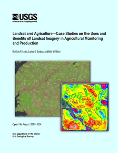
Landsat and Agriculture Case Studies
A team of economists from the USGS Fort Collins Science Center has published a new report on Landsat imagery use in agriculture.
Exhibit Fusing Art and Science Coming to Bismarck
Earth as Art, a U.S. Geological Survey traveling exhibit that merges art with dramatic Landsat imagery of the earth’s surface, is coming to Bismarck for the month of April.
RIT Researchers Win USGS Grant to Improve Landsat 8 Data
Rochester Institute of Technology researchers have won funding from the U.S. Geological Survey to ensure accurate temperature data from the Landsat 8 satellite. Climate researchers depend on public data from the Earth-sensing satellite to measure surface changes over time.
Landsat Reveals Bird Habitat Loss in California
Drought and reduced seasonal flooding of wetlands and farm fields threaten a globally important stopover site for tens of thousands of migratory shorebirds in California’s Sacramento Valley, a new Duke University-led study shows.
New “Landsat Collections” Help Facilitate Land Change Science
Access to consistent high-quality images to study changes on Earth’s surface is getting easier.
UNOSAT Maps Flood Extent Near Lake Urmia with Landsat 8
A Landsat 8-based map showing regions south of Iran’s Lake Urmia that have been effected by recent flooding has been created for UN decision makers.
Canada’s Forests Return Following Disturbance
Tens-of-thousands of Landsat images representing billions of pixels, were used by White and co-authors to map forest wildfire and harvesting on an annual basis and to then characterize the return of forest vegetation following the disturbance.
Landsat Images Provided to the Disaster Charter, Mar. 2017
You can think of the Charter as a one-stop-shop for impact maps—an essential resource, since in many cases satellite data are the only practical method to assess current ground conditions after a disaster.
A Farewell to EO-1: Celebrating 17 Years of NASA’s ‘Little Earth Satellite That Could’
EO-1 was a technology validation mission for testing cutting-edge advancements that have been and are being implemented on current and future satellite missions.
Landsat and Agriculture Case Studies
A team of economists from the USGS Fort Collins Science Center has published a new report on Landsat imagery use in agriculture.
Exhibit Fusing Art and Science Coming to Bismarck
Earth as Art, a U.S. Geological Survey traveling exhibit that merges art with dramatic Landsat imagery of the earth’s surface, is coming to Bismarck for the month of April.
RIT Researchers Win USGS Grant to Improve Landsat 8 Data
Rochester Institute of Technology researchers have won funding from the U.S. Geological Survey to ensure accurate temperature data from the Landsat 8 satellite. Climate researchers depend on public data from the Earth-sensing satellite to measure surface changes over time.
Landsat Reveals Bird Habitat Loss in California
Drought and reduced seasonal flooding of wetlands and farm fields threaten a globally important stopover site for tens of thousands of migratory shorebirds in California’s Sacramento Valley, a new Duke University-led study shows.
New “Landsat Collections” Help Facilitate Land Change Science
Access to consistent high-quality images to study changes on Earth’s surface is getting easier.
