
A New Landsat-based Snow Cover Product from USGS
David Selkowitz, a Research Geographer with the USGS Alaska Science Center, and his team have developed a snow cover product, that allows users to look at historical snow cover through time. Selkowitz presented a poster on the Landsat-based data product at #AGU15. Here’s what we learned from him this week.
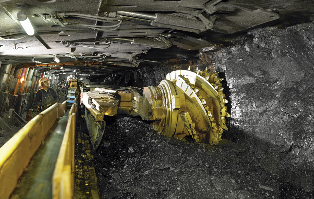
Assessing Longwall Mining Impacts on the Forests Above
Erin Pfeil-McCullough, a graduate student at the University of Pittsburgh, gave a talk at #AGU15 on insights that she has gained from her research to determine what impacts longwall mining has on forest canopies above as the ground subsides and local hydrology is altered.
Monitoring Water Quality Trends in the Niger River Basin
Chase Mueller from NASA Ames Research Center shared the results of a project that uses Landsat and MODIS data to monitor water quality trends at #AGU15. We spoke with him about his findings.
Tracking Microbiological Health Hazards in Burkina Faso
Elodie Robert from the French National Center for Scientific Research presented preliminary results of her research at #AGU15 that aims to track microbiological heath hazards based on surface water turbidity in West Africa.
Forest Disturbances and their Causes in California
Courtney Reents, a graduate student at University of Illinois at Urbana-Champaign, presented a poster on forest disturbance in California at #AGU15.
Survival of a Tropical Glacier
William Kochtitzky, a student from Dickinson College, presented a poster on glacial changes on Peru’s Nevado Coropuna volcano at #AGU15.
Landsat Helps Inform Restoration Decisions in the Great Lakes
Charles Perry, a Research Soil Scientist with the USDA’s Forest Inventory and Analysis group, gave a talk about his research that uses Landsat to monitor land use and land cover change in watersheds surrounding the Great Lakes at #AGU15. He is able to link the land use and land cover change information with other ancillary data to predict water quality, such as the amount of phosphorus (which feeds algae) in the lakes.
Finding Land Surface Change with Landsat: An Automation
Jennifer Rover, a Geographer with the U.S. Geological Survey, gave a talk on an automated method she developed to assess long-term change to Earth’s surface using Landsat at #AGU15.
Landsat Enables Seasonal Fuel Dynamic Estimations for Southwest U.S.
By incorporating seasonal variability of herbaceous cover and biomass in the Southwest U.S., fine fuel loading can be measured. The measurements are then used to capture changes to fire behavior fuel models based on the current fire season.
LANDFIRE Innovation for Landsat Image Compositing
The LANDFIRE program produces annual fire disturbance maps for the conterminous U.S. Recently, the program developed an image tiling and compositing process to aid in vegetation change mapping.
Landsat at Explore@Goddard
On Saturday, September 26, over 20,000 people attended an all-day public open house at NASA’s Goddard Space Flight Center in Greenbelt, Maryland.
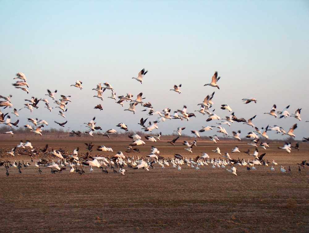
Landsat Helps Feed the Birds
The BirdReturns program, created by The Nature Conservancy of California, is an effort to provide “pop-up habitats” for some of the millions of shorebirds, such as sandpipers and plovers, that migrate each year from their summer breeding grounds in Alaska and Canada to their winter habitats in California, Mexico, Central and South America.
USGS Maps Anthropogenic Land Use Trends, 1974–2012
More and more we hear the term “anthropocene” used to describe the current epoch of our planet when humankind has had a profound impact on Earth. This month, the U.S. Geological Survey has released a Landsat-based report and dataset on anthropogenic land use trends in the U.S. between 1974 and 2012.
A Beautiful Menace: Tracking Water Hyacinth with Landsat
Delivering maps and tabular summaries of live water hyacinth coverage in waterways of the Sacramento-San Joaquin River Delta from the latest cloud-free Landsat satellite imagery.
New Global Data Finds Tropical Forests Declining in Overlooked Hotspots
The world lost more than 18 million hectares (45 million acres) of tree cover in 2014, an area twice the size of Portugal, according to new data from the University of Maryland (UMD) and Google released by Global Forest Watch. The data find that tropical forests are in the most trouble, losing 9.9 million hectares (24.5 million acres) of tree cover in 2014 – over half of the global total. A three-year-average shows tree cover loss is the highest it’s been since 2001.
Landsat Images Provided to the International Charter in August 2015
The Charter concept is this: a single phone number is made available to authorized parties providing 24/7 contact to a person who can activate the charter. Once activated, a project manager takes charge. The project manager knows what satellite resources are available, how to task them to collect data, and how to quickly analyze the collected data to create impact maps for first responders. These maps, provided to responders for free, often show where the damage is and where crisis victims are, allowing responders to plan and execute relief support.
Landsat Benefited U.S. Economy by $1.8 Billion in 2011
The 2.38 million Landsat images freely downloaded in 2011, benefited the U.S. economy by $1.8 billion found a new study published this month by a team of economists from Colorado State University and the USGS Fort Collins Science Center.
Landsat Enables Seasonal Fuel Dynamic Estimations for Southwest U.S.
By incorporating seasonal variability of herbaceous cover and biomass in the Southwest U.S., fine fuel loading can be measured. The measurements are then used to capture changes to fire behavior fuel models based on the current fire season.
LANDFIRE Innovation for Landsat Image Compositing
The LANDFIRE program produces annual fire disturbance maps for the conterminous U.S. Recently, the program developed an image tiling and compositing process to aid in vegetation change mapping.
Landsat at Explore@Goddard
On Saturday, September 26, over 20,000 people attended an all-day public open house at NASA’s Goddard Space Flight Center in Greenbelt, Maryland.
Landsat Helps Feed the Birds
The BirdReturns program, created by The Nature Conservancy of California, is an effort to provide “pop-up habitats” for some of the millions of shorebirds, such as sandpipers and plovers, that migrate each year from their summer breeding grounds in Alaska and Canada to their winter habitats in California, Mexico, Central and South America.
USGS Maps Anthropogenic Land Use Trends, 1974–2012
More and more we hear the term “anthropocene” used to describe the current epoch of our planet when humankind has had a profound impact on Earth. This month, the U.S. Geological Survey has released a Landsat-based report and dataset on anthropogenic land use trends in the U.S. between 1974 and 2012.
A Beautiful Menace: Tracking Water Hyacinth with Landsat
Delivering maps and tabular summaries of live water hyacinth coverage in waterways of the Sacramento-San Joaquin River Delta from the latest cloud-free Landsat satellite imagery.
New Global Data Finds Tropical Forests Declining in Overlooked Hotspots
The world lost more than 18 million hectares (45 million acres) of tree cover in 2014, an area twice the size of Portugal, according to new data from the University of Maryland (UMD) and Google released by Global Forest Watch. The data find that tropical forests are in the most trouble, losing 9.9 million hectares (24.5 million acres) of tree cover in 2014 – over half of the global total. A three-year-average shows tree cover loss is the highest it’s been since 2001.
Landsat Images Provided to the International Charter in August 2015
The Charter concept is this: a single phone number is made available to authorized parties providing 24/7 contact to a person who can activate the charter. Once activated, a project manager takes charge. The project manager knows what satellite resources are available, how to task them to collect data, and how to quickly analyze the collected data to create impact maps for first responders. These maps, provided to responders for free, often show where the damage is and where crisis victims are, allowing responders to plan and execute relief support.
Landsat Benefited U.S. Economy by $1.8 Billion in 2011
The 2.38 million Landsat images freely downloaded in 2011, benefited the U.S. economy by $1.8 billion found a new study published this month by a team of economists from Colorado State University and the USGS Fort Collins Science Center.
