
Each year for a week in October, the American Geosciences Institute celebrates Earth Science Week by featuring a geoscience theme. This year, from October 8-14, we’re celebrate the theme Geoscience Innovating for Earth and People by exploring the globe with NASA.
NASA Earth Science in Action
From the vantage point of space, NASA works to increase our understanding of our planet, improve lives, and safeguard our future. America’s space agency develops and shares tools, observations, and applications to help map and measure our planet’s vital signs and study natural and human-caused changes to our climate and environment.
NASA operates dozens of missions to help us understand Earth on a global scale, while also connecting local events and phenomena to the big picture. Using satellites, airplanes, balloons, ships, ground stations, and the International Space Station, scientists collect data about our air and clouds; about forests, desert, cities; about ocean currents, temperatures, and life; and ice on land and in the sea.
Poster Files (pdf):
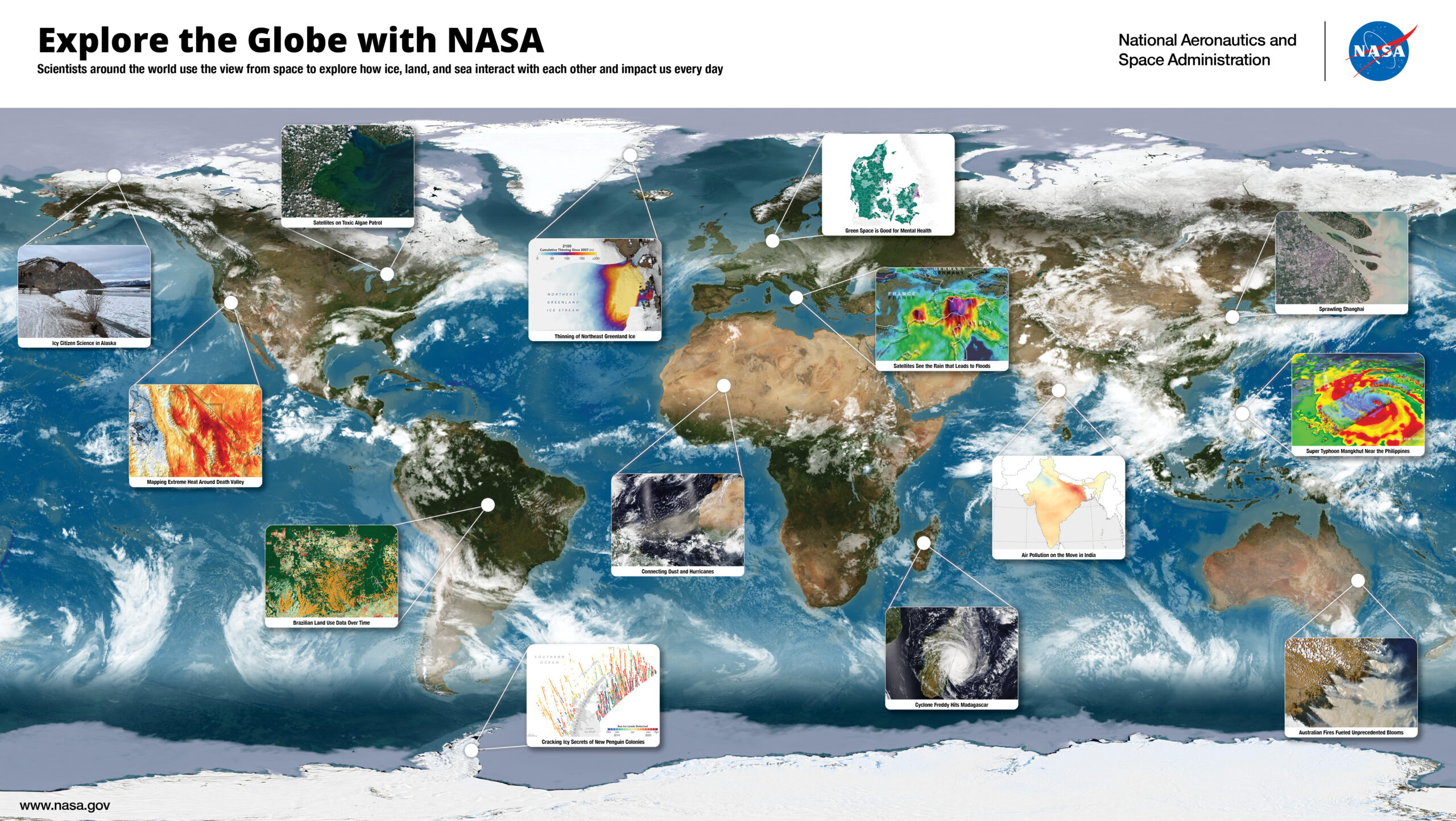
This StoryMap explores 14 different applications of NASA Earth Science Missions featuring data from satellites like Landsat, IceSAT-2, GPM, GLOBE, Terra, NOAA-20, and more and how these data benefit society every day.
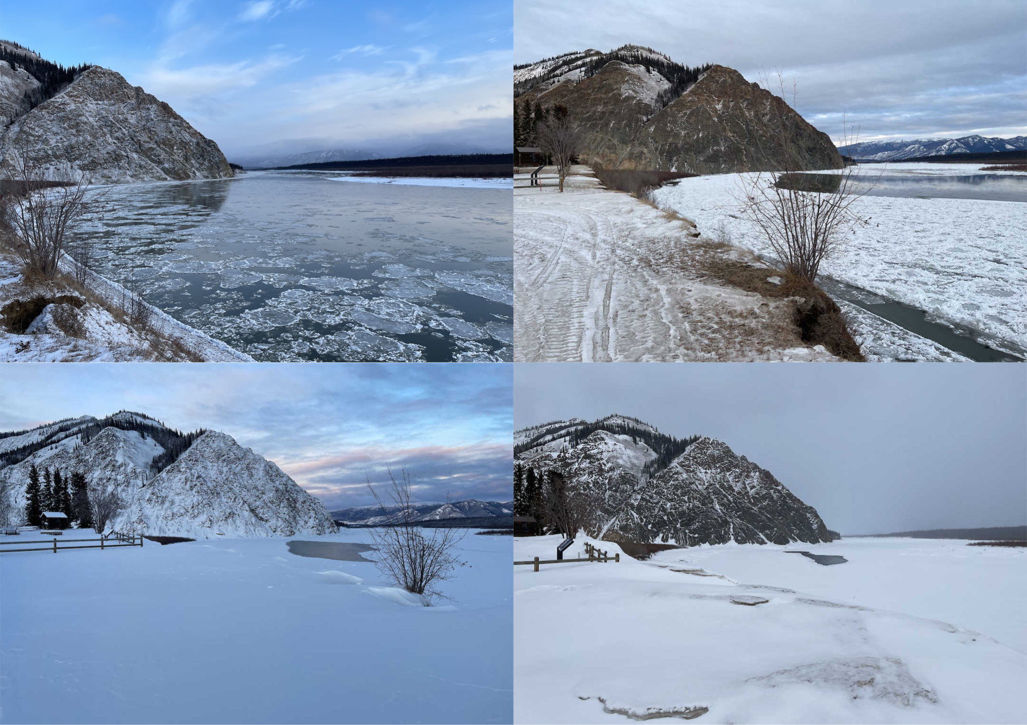
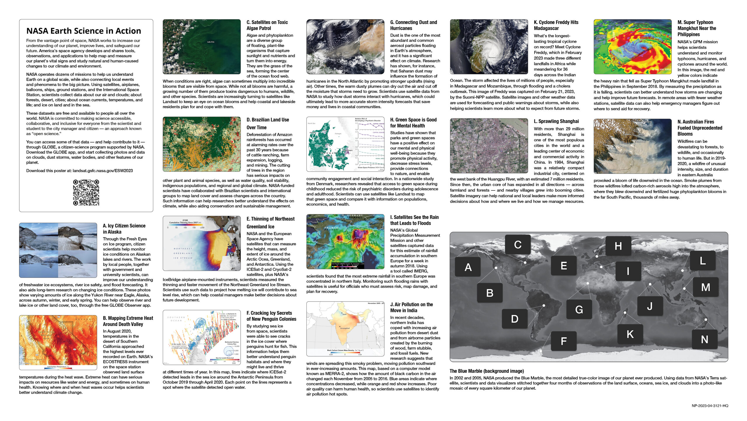
Through the Fresh Eyes on Ice program, citizen scientists help monitor ice conditions on Alaskan lakes and rivers. The work by local people, together with government and university scientists, can improve our understanding of freshwater ice ecosystems, river ice safety, and flood forecasting. It also aids long-term research on changing ice conditions. These photos show varying amounts of ice along the Yukon River near Eagle, Alaska, across autumn, winter, and early spring. You can help observe river and lake ice or other land cover, too, through the free GLOBE Observer app.
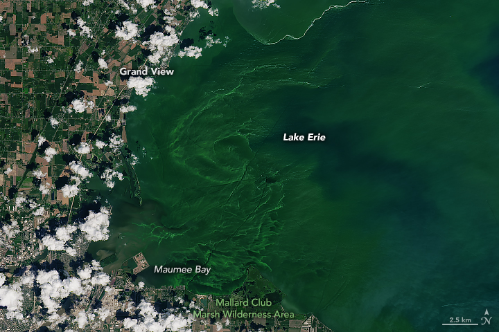
Algae and phytoplankton are a diverse group of floating, plant-like organisms that capture sunlight and nutrients and turn them into energy. They are the grass of the sea, forming the center of the ocean food web. When conditions are right, algae can sometimes multiply into incredible blooms that are visible from space. While not all blooms are harmful, a growing number of them produce toxins dangerous to humans, wildlife, and other species. Scientists are increasingly turning to satellites like Landsat to keep an eye on ocean blooms and help coastal and lakeside residents plan for and cope with them.
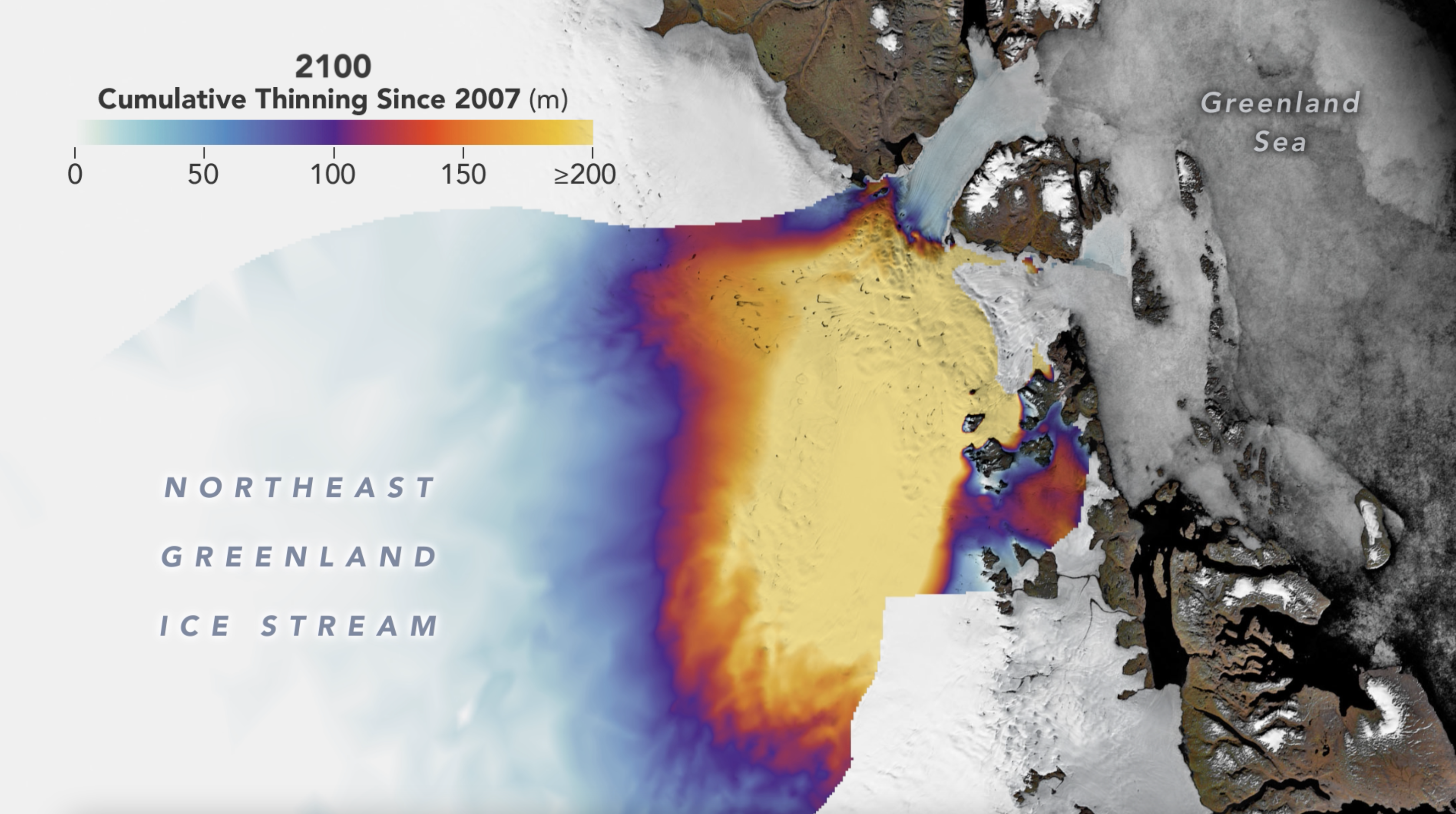
NASA and the European Space Agency have satellites that can measure the height, mass, and extent of ice around the Arctic Ocea, Greenland, and Antarctica. Using the ICESat-2 and CryoSat-2 satellites, plus NASA’s IceBridge airplane-mounted instruments, scientists measured the thinning and faster movement of the Northeast Greenland Ice Stream. Scientists use such data to project how melting ice will contribute to sea level rise, which can help coastal managers make better decisions about future development.
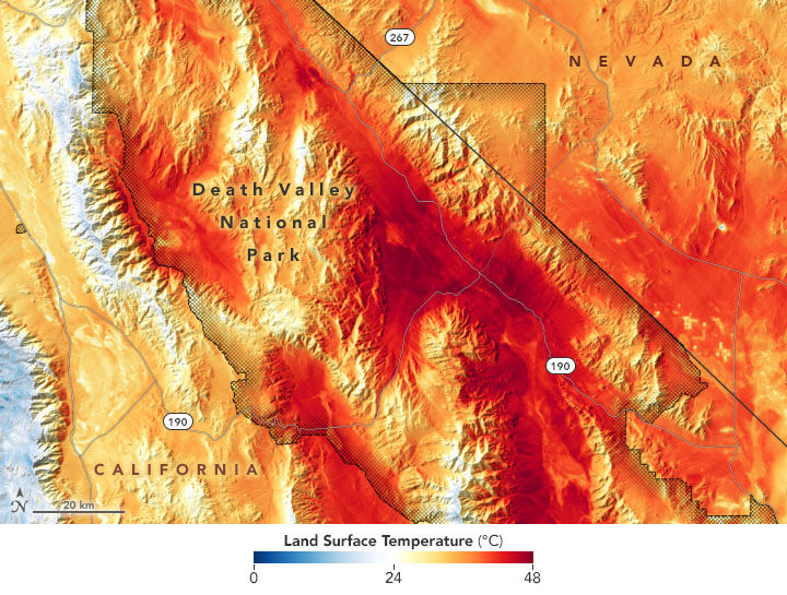
In August 2020, temperatures in the desert of Southern California approached the highest levels ever recorded on Earth. NASA’s ECOSTRESS instrument on the space station observed land surface temperatures during the heat wave. Extreme heat can have serious impacts on resources like water and energy, and sometimes on human health. Knowing where and when heat waves occur helps scientists better understand climate change.
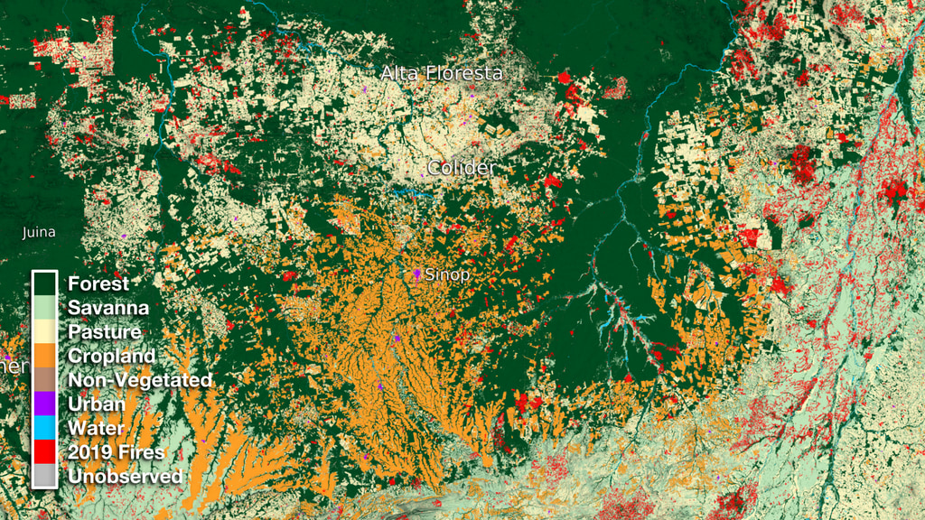
Deforestation of Amazon rainforests has occurred at alarming rates over the past 30 years because of cattle ranching, farm expansion, logging, and mining. The cutting of trees in the region has serious impacts on other plant and animal species, as well as water quality, soil stability, indigenous populations, and regional and global climate. NASA-funded scientists have collaborated with Brazilian scientists and international groups to map land cover and assess changes across the country. Such information can help researchers better understand the effects on climate, while also aiding conservation and sustainable management.
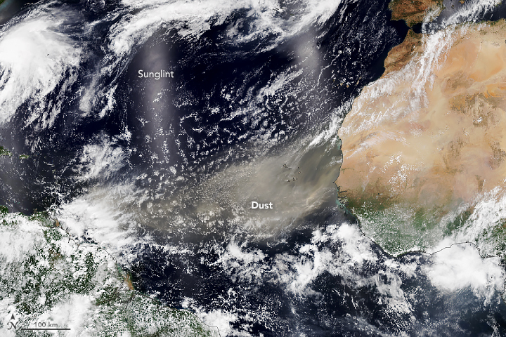
Dust is the one of the most abundant and common aerosol particles floating in Earth’s atmosphere, and it has a significant effect on climate. Research has shown, for instance, that Saharan dust may influence the formation of hurricanes in the North Atlantic by promoting stronger updrafts (rising air). Other times, the warm dusty plumes can dry out the air and cut off the moisture that storms need to grow. Scientists use satellite data from NASA to study how dust storms interact with hurricanes, which could ultimately lead to more accurate storm intensity forecasts that save money and lives in coastal communities.
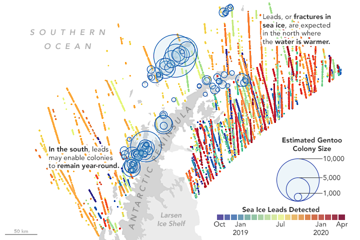
By studying sea ice from space, scientists were able to see cracks in the ice cover where penguins hunt for fish. This information helps them better understand penguin habitats and where they might live and thrive at different times of year. In this map, lines indicate where ICESat-2 detected leads in the sea ice around the Antarctic Peninsula from October 2019 through April 2020. Each point on the lines represents a spot where the satellite detected open water.
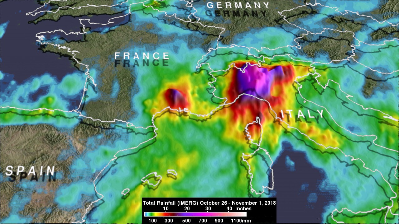
NASA’s Global Precipitation Measurement Mission and other satellites captured data for this estimate of rainfall accumulation in southern Europe for a week in autumn 2018. Using a tool called IMERG, scientists found that the most extreme rainfall in southern Europe was concentrated in northern Italy. Monitoring such flooding rains with satellites is useful for officials who must assess risk, map damage, and plan for recovery.
What’s the longest-lasting tropical cyclone on record? Meet Cyclone Freddy, which in February 2023 made three different landfalls in Africa while meandering for 36 days across the Indian Ocean. The storm affected the lives of millions of people, especially in Madagascar and Mozambique, through flooding and a cholera outbreak. This image of Freddy was captured on February 21, 2023, by the Suomi-NPP satellite. Satellite images and other weather data are used for forecasting and public warnings about storms, while also helping scientists learn more about what to expect from future storms.
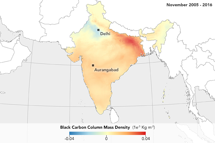
In recent decades, northern India has coped with increasing air pollution from desert dust and from airborne particles created by the burning of wood, farm stubble, and fossil fuels. New research suggests that winds are spreading this smoky problem, moving pollution southward in ever-increasing amounts. This map, based on a computer model known as MERRA-2, shows how the amount of black carbon in the air changed each November from 2005 to 2016. Blue areas indicate where concentrations decreased, while orange and red show increases. Poor air quality can harm human health, so scientists use satellites to identify air pollution hot spots.
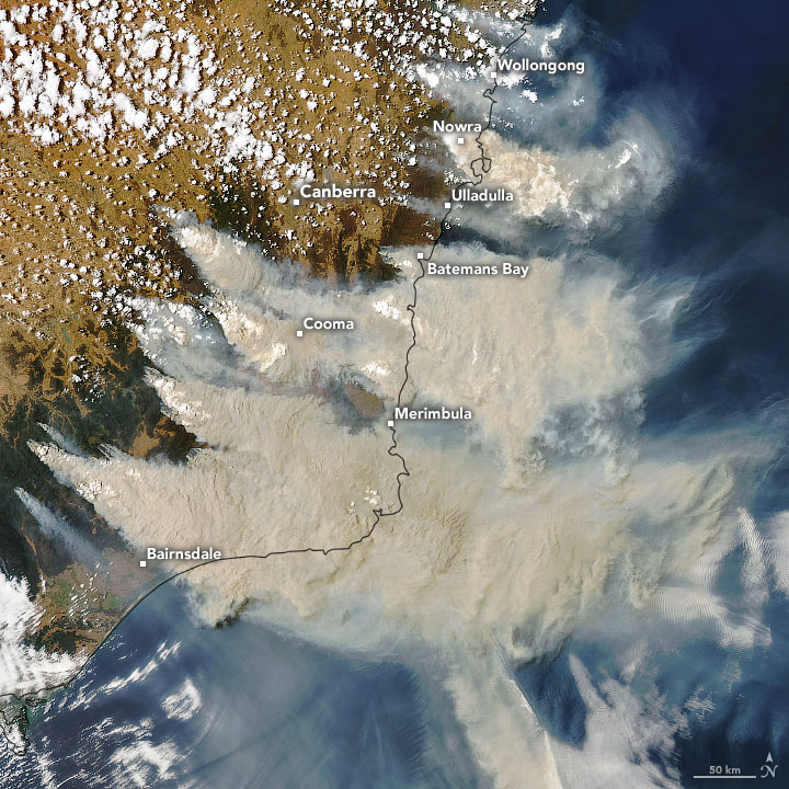
Wildfires can be devastating to forests, to wildlife, and occasionally to human life. But in 2019- 2020, a wildfire of unusual intensity, size, and duration in eastern Australia provoked a bloom of life downwind in the ocean. Smoke plumes from those wildfires lofted carbon-rich aerosols high into the atmosphere, where they blew downwind and fertilized huge phytoplankton blooms in the far South Pacific, thousands of miles away.
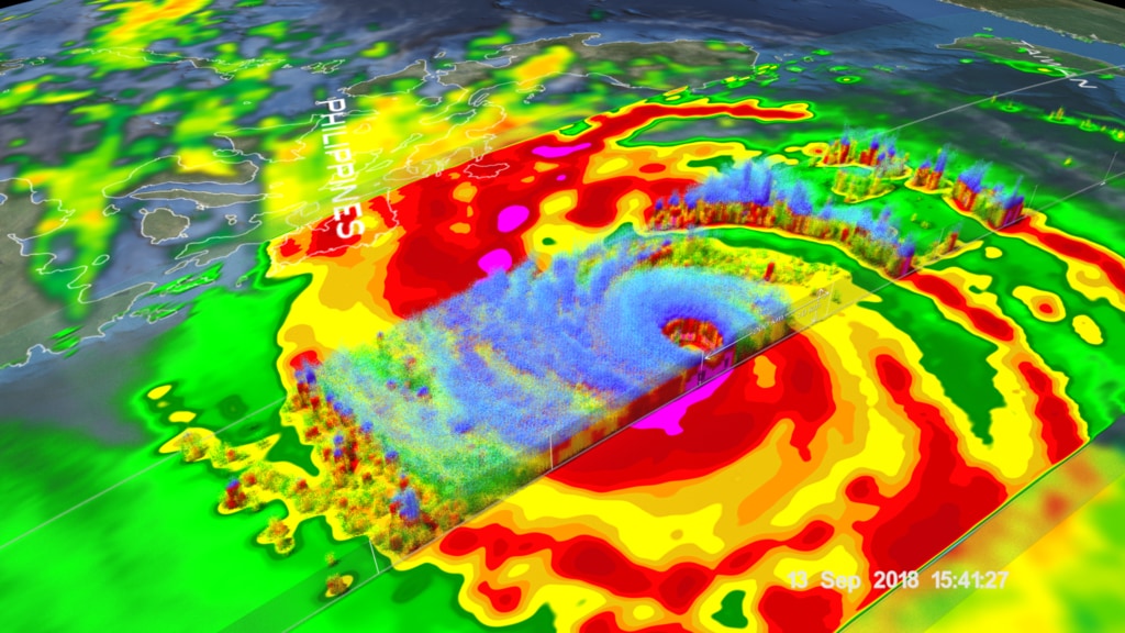
NASA’s GPM mission helps scientists understand and monitor typhoons, hurricanes, and cyclones around the world. In this image, the red and yellow colors indicate the heavy rain that fell as Super Typhoon Mangkhut made landfall in the Philippines in September 2018. By measuring the precipitation as it is falling, scientists can better understand how storms are changing and help improve future forecasts. In remote areas with fewer weather stations, satellite data can also help emergency managers figure out where to send aid for recovery.
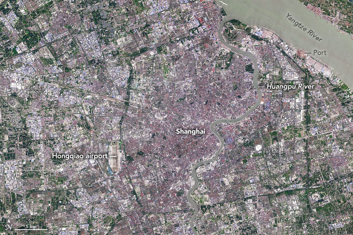
With more than 29 million residents, Shanghai is one of the most populous cities in the world and a leading center of economic and commercial activity in China. In 1984, Shanghai was a relatively compact industrial city, centered on the west bank of the Huangpu River, with an estimated 7 million residents. Since then, the urban core of has expanded in all directions — across farmland and forests — and nearby villages grew into booming cities. Satellite imagery can help national and local leaders make more informed decisions about how and where we live and how we manage resources.
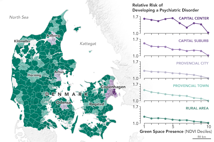
Studies have shown that parks and green spaces have a positive effect on our mental and physical well-being because they promote physical activity, decrease stress levels, provide connections to nature, and enable community engagement and social interaction. In a nationwide study from Denmark, researchers revealed that access to green space during childhood reduced the risk of psychiatric disorders during adolescence and adulthood. Scientists can use satellites like Landsat to map that green space and compare it with information on populations, economics, and health.
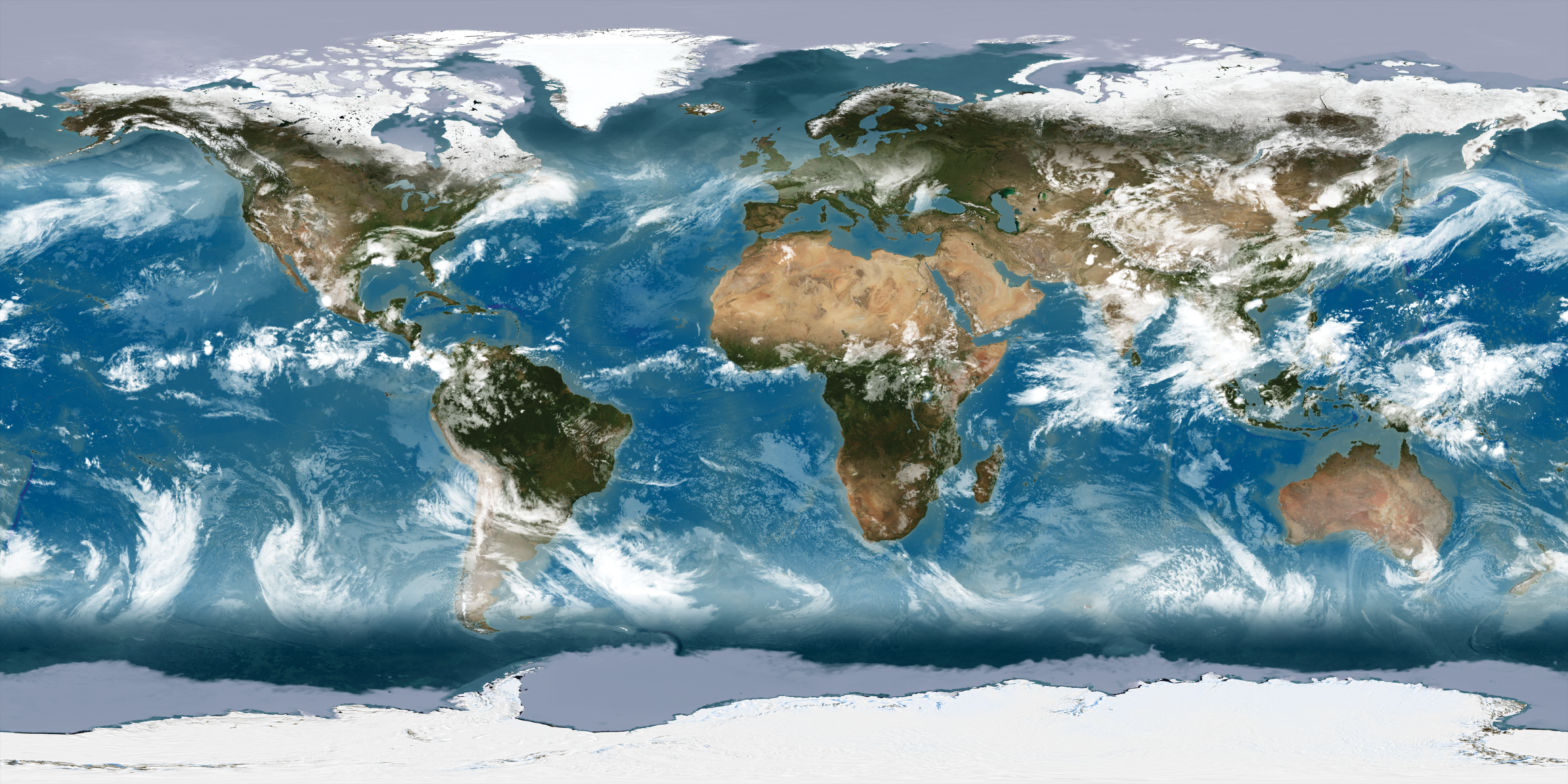
In 2002 and 2005, NASA produced the Blue Marble, the most detailed true-color image of our planet ever produced. Using data from NASA’s Terra satellite, scientists and data visualizers stitched together four months of observations of the land surface, oceans, sea ice, and clouds into a photo-like mosaic of every square kilometer of our planet.
Additional Resources
+ NASA Earth Observatory
+ GPM Mission
+ GLOBE Citizen Science
+ ICESat-2 Mission
+ Terra & Aqua MODIS
+ NASA Earth Data
+ NASA WorldView
Poster design by Allison Nussbaum and Ginger Butcher in collaboration with Michael Carlowicz, Valerie Casasanto, Jennifer Brennan, Nyssa Rayne, Kristen Weaver, Dorian Janney, Elizabeth Joyner, and Trena Ferrell.
