
Using the world’s first global, Landsat-based 30-meter resolution map of tree cover, the researchers found that ambiguity of the term “forest” has the potential to create discrepancies double the size of the 6 percent difference found between current maps. While ecologists have long understood the complexity comprised by the concept of “forest”, and while geographers have called for the term to be more uniformly defined across monitoring entities, no one had quantified the scope of the problem.
“Whereas previous studies mentioned the discrepancy, our analysis quantified and mapped it globally and connected it to estimates of biomass and economic value,” says Joseph Sexton, a senior scientist at the University of Maryland’s Global Land Cover Facility and lead author of the study.
The findings were recently published in Nature Climate Change by a team of researchers from the University of Maryland, NASA Goddard Space Flight Center, the National Wildlife Federation, the Global Environment Facility, and Duke University.
Error contributions of the technological issues that impede satellite-based forest maps—such as persistent cloud cover in the tropics, canopy shadows, and the complexity of forest structure—were shown to be small in comparison to this definitional divide.
“It’s not the technology’s fault. Today’s satellites provide us with a sufficient precision to make ecological measurements of forests,” Sexton says. The study found that the agreement between eight global satellite-derived forest cover maps (in terms of area) is massive. These maps, created by U.S. and European science agencies and universities, use both coarse and medium resolution satellite data, and rely on differing international definitions of forest. For example, “forest” is considered anywhere with at least 10 percent forest cover in some definitions, as opposed to at least 30 percent forest cover in others. Where and why the maps disagree is now better understood.

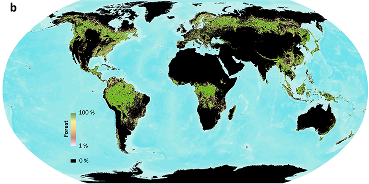
When different definitions of forest are used, satellite forest cover measurements can vary widely. Here global forest cover as measured by Landsat is shown using two different UN Framework Convention of Climate Change (UNFCCC) forest definitions: 10 percent tree cover (left) and 30 percent tree cover (right). Data are publicly available at www.landcover.org. Image credits: Sexton, et al.

Semantics can sully global forest area measurements, and this is problematic because deforestation has major implications for greenhouse gas emissions, climate change and biodiversity reduction. It was early satellite-based maps of forest cover change that helped raise the alert about the widespread severity of global deforestation. This factored into the creation of policy initiatives such as the Kyoto Protocol, Aichi Biodiversity Targets, and REDD+ (Reducing Emissions from Deforestation and Forest Degradation).
Programs like REDD+ incentivize countries to keep forests intact and sustainably managed by assigning a value to the forest’s stored carbon. So accurate measurements of forest cover via synoptic, unbiased sources such as satellites are paramount—which means an unambiguous definition of forest is too. In the tropics, the authors found that definitional discrepancies could translate into $1 trillion worth of carbon credits.
To stem this ambiguity, the authors call for either a single, unambiguous definition of forest that can be used globally or a shift away from “forest/non-forest” maps to maps of measureable ecological characteristics like tree cover, canopy height, and biomass.

A prime example of where a clear forest definition has big implications is Southeast Asia, where the growth of the oil palm sector has skyrocketed in the last decade.
“The projected global increase in demand for palm oil is likely to cause widespread expansion of palm plantations in the region at the cost of forest,” paper co-author and NASA Goddard/National Wildlife Federation scientist Praveen Noojipady explains.
Here, palm oil producers’ commitments to zero deforestation are colliding with increasing palm oil demand. Clearly defining where expansion can and cannot occur, based on a forest definition that accounts for carbon stock, will prevent biodiverse and carbon-rich native forests (and their dense under-canopy vegetation) from being turned into plantations, which are much less carbon-dense.
“An unambiguous definition of forest including ecological characteristics will not only protect forests of High Carbon Stock (HCS), but also facilitate sustainable palm oil production with least damage to carbon rich ecosystems.”
With the insight gained by this research, scientists now have a blueprint for improving the satellite-derived maps that can help protect these carbon rich ecosystems.
Reference:
+ NASA/USGS mission helps answer: What is a forest?
+ Mapping Forest Loss with Landsat, NASA Earth Observatory
+ Counting trees: 143 scientist just did; CIFOR Forest News
+ Agree on biodiversity metrics to track from space, Nature
+ Calling a ‘forest’ by another name may result in different statistics, The Metric


