Presentation title:
Extracting Outcrop Extents in Antarctica: Current problems, new solutions and a complete dataset for the Antarctic continent
What are the major findings of your research?
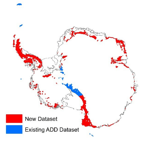
Differentiating rock outcrop from snow and ice is a particular problem in the Antarctic—extensive cloud clover along with widespread shaded areas due to low solar elevation angles and extreme topography causes difficulty in accurately delineating rock extent. Commonly used techniques, such as the Normalised Difference Snow Index (NDSI) do not perform well in the Antarctic due to misclassification of areas of shade and cloud cover.
We used Landsat 8’s multispectral data, including thermal bands, which allowed us to generate a new automated methodology for delineation of rock outcrop in Antarctica, overcoming the limitations of previous techniques and generating a new rock outcrop dataset with higher accuracies than previously achieved. We found exposed rock forms 0.18% of the total land area of Antarctica, half of previous estimates.
What insight did you gain from Landsat that would have been impossible to glean otherwise?
In order to produce a rock outcrop map for the entire Antarctic continent, we required a freely available georeferenced multispectral dataset. The dataset needed to cover the high latitudes; be recently acquired; be of a high enough resolution to identify individual outcrops and geomorphological features; and have suitable coverage of the continent.
On this basis, the Landsat 8 multispectral satellite data was chosen for analysis as no other platform met these requirements. It would not have been possible, or at least would have been prohibitively expensive, to carry out this study without Landsat data.
What benefits did Landsat 8 data offer?
Our requirements for the data we needed led us to primarily use Landsat 8, as we needed recently acquired multispectral imagery for the whole continent. Landsat 8’s multispectral and thermal bands allowed for the generation of a new automated methodology for extracting rock extent in the Antarctic.
Will your new Antarctica rock outcrop dataset be publicly available?
Yes. The paper is currently in review and the dataset will be available as supplementary material, and will also be available to download freely from the Antarctic Digital Database.
Anyone can freely download Landsat data from the USGS EarthExplorer or LandsatLook.
Further Reading:
+ Landsat at #AGU15