
Large nations such as Canada, have previously relied on data from satellites such as MODIS and AVHRR for national forest characterizations. These valuable datasets and information outcomes allowed for map production and trend analysis of land dynamics, but were of a spatial resolution that was suboptimal for supporting management, reporting, and policy development.
With the 2008 opening of the U.S. Geological Survey Landsat archive, Canada got the best of both worlds: national data coverage (~1 billion hectares) at a spatial resolution of 30 m. Having access to all Landsat in an analysis-ready form has allowed scientists from the Canadian Forest Service (Natural Resources Canada), and the University of British Columbia, to produce large area, gap-free, surface reflectance science products (White et al. 2014).
Implementing the Composite2Change (C2C) approach, the research team has generated annual gap-free image composite products representing 1984 to 2012 (Hermosilla et al. 2015a), which are now being used to characterize change, land cover, and forest structure. The national time series of image composites offers a rich information source for both identifying and attributing forest changes (Hermosilla et al. 2015b).
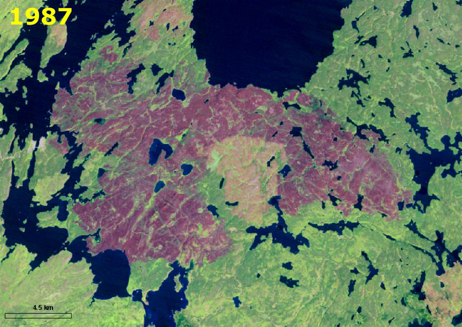
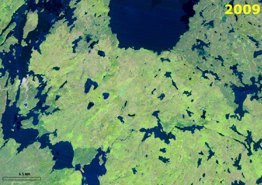
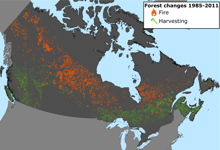
For a large nation such as Canada, with multiple jurisdictions responsible for forest stewardship, the ability to systematically produce nationally consistent information products is necessary to mitigate the different regional mapping protocols, forest inventory cycles, as well as differing definitions. The national change products relate a range of disturbances, chiefly wildfire and forest harvest. Wildfire can be variable year-on-year, with harvest levels relatively constant. The time series nature of the data allows for investigation of the return of vegetation following disturbance, with a positive vegetation response evident for almost all disturbed pixels.
Globally, other nations have similar information needs associated with terrestrial monitoring and will benefit from free and open access to the analysis-ready products of the Landsat archive, which continues to expand under the auspices of the Landsat Global Archive Consolidation initiative (Wulder et al., 2016). And, the common use of Landsat data by the global community allows for an understanding of methods and outcomes across borders as well as the sharing of methods and lessons learned.
“The Landsat program is a global asset, allowing nations to consistently, systematically, and transparently characterize their terrestrial ecosystems,” says Mike Wulder, a Canadian Forest Service scientist and member of the Landsat Science Team.
Acknowledgement: Project supported by the Canadian Space Agency. Project lead: Mike Wulder (CFS); Project team: Joanne White (CFS), Geordie Hobart (CFS), Txomin Hermosilla (UBC) and Nicholas Coops (UBC).
References
Hermosilla, T., Wulder, M.A., White, J.C., Coops, N.C., Hobart, G.W. 2015a. An integrated Landsat Time Series protocol for change detection and generation of annual gap-free surface reflectance composites. Remote Sensing of Environment, 158: 220–234. http://dx.doi.org/10.1016/j.rse.2014.11.005
Hermosilla, T., Wulder, M.A., White, J.C., Coops, N.C., Hobart, G.W. 2015b. Regional detection, characterization, and attribution of annual forest change from 1984 to 2012 using Landsat-derived time-series metrics. Remote Sensing of Environment, 170: 121–132. http://dx.doi.org/10.1016/j.rse.2015.09.004
White, J.C., Wulder, M.A., Hobart, G.W., Luther, J. E., Hermosilla, T., Griffiths, P., Coops, N.C., Hall, R.J., Hostert, P., Dyk, A., Guindon, L. 2014. Pixel-based image compositing for large-area dense time series applications and science. Canadian Journal of Remote Sensing, 40(3), 192–212. http://dx.doi.org/10.1080/07038992.2014.945827
Wulder, M.A, White, J.C., Loveland, T.R., Woodcock, C.E., Belward, A.S., Cohen, W.B. Fosnight, G., Shaw, J., Masek, J.G., Roy, D.P. 2016. The global Landsat archive: Status, consolidation, and direction. Remote Sensing of Environment. http://dx.doi.org/10.1016/j.rse.2015.11.032
Further Reading
+ Tracking forest change and recovery in Canada
+ How disturbances shape Canada’s forests
This science brief was provided by the Canadian Forest Service’s remote sensing research team and edited by Laura Rocchio from the NASA Landsat Communications and Public Engagement team.


