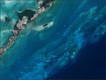
Not long ago, people searching for coral reefs traveled by boat or plane, and relied on notes from captains who spotted them on voyages in the 1800s. Knowing the location and distribution of reefs is important for exploring their role in the health of the vast shallow coastal waters upon which we are so dependent. We still don’t know how many square kilometers of reefs there are in the world – estimates range from 255,000 to 1,350,000 sq km! But today researchers are using the Landsat satellite images to map the reefs of the world, to classify them by structure and type, and to provide this vital information to local governments responsible for managing the reef systems. Because of Landsat, researchers can do this from their offices, without the expense and time required to search hundreds of square kilometers by boat or plane. They search georeferenced Landsat imagery where they can locate reefs to within tens of meters, and study changes to those reefs over time.
To learn more about mapping coral reefs, visit the University of South Florida’s Institute for Marine Remote Sensing (IMaRS) Millennium Coral Reef Mapping Project (external link).
Contributor: Terry Arvidson
+ Read NASA Feature: New Worldwide Coral Reef Library Created

Be Part of What’s Next: Emerging Applications of Landsat at AGU24
Anyone making innovative use of Landsat data to meet societal needs today and during coming decades is encouraged to submit and abstract for the upcoming “Emerging Science Applications of Landsat” session at AGU24.


