Extreme Melt on Antarctica’s George VI Ice Shelf
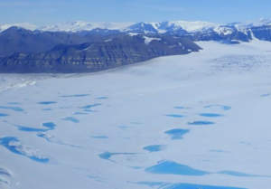
Antarctica’s George VI Ice Shelf experienced record melting during the 2019-2020 summer season.

Antarctica’s George VI Ice Shelf experienced record melting during the 2019-2020 summer season.
Antarctica experienced a sixfold increase in yearly ice mass loss between 1979 and 2017.
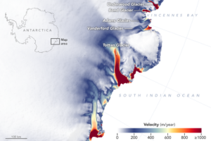
New detailed NASA maps of ice velocity and elevation show that a group of glaciers spanning one-eighth of East Antarctica’s coast have begun to lose ice over the past decade, hinting at widespread changes in the ocean.
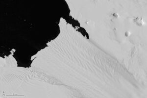
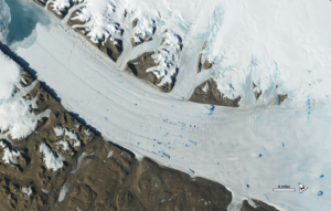
The Thermal Infrared Sensor (TIRS) on Landsat 8 captured a new snap of the 2,240-square-mile iceberg that split off from the Antarctic Peninsula’s Larsen C ice shelf on July 10-12.
Using Landsat to closely monitor changes in ‘grounding line’ position in West Antarctica.
Mr. Chuter presented a poster on new mass balance estimates and velocity changes for parts of West Antarctica.
Scientists have created a mosaic of digital images collected from space showing the frozen continent of Antarctica—one of the most remote and least known places
Antarctica may not be the world’s largest landmass — it’s the fifth-largest continent — but resting on top of that land is the world’s largest
Source: USGS The U. S. Geological Survey (USGS) in collaboration with the National Aeronautics and Space Administration (NASA) and the British Antarctic Survey (BAS) is developing
The Landsat program, a joint venture between NASA and the U.S. Geological Survey (USGS), has been observing Earth for over 50 years, collecting breathtaking imagery
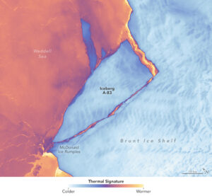
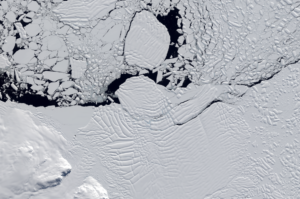
The Brunt Ice Shelf lost a large wedge of floating ice, the third sizeable iceberg to calve from the shelf in recent years. The TIRS instrument on Landsat 9 captured false-color images of the calving.
Landsat satellites have begun regularly acquiring images of ice at the poles during the winter, with enlightening results.
New research shows that while some Antarctic ice shelves have been thinning since at least the 1970s, widespread thinning accelerated in the 1990s.
“While many previous studies have reported ongoing ice shelf thinning around Antarctica since the 1990s, we didn’t previously know that a lot of it started
Select Landsat Publications January 2025 Di Vittorio, C. A.; Wiles, M.; Rabby, Y. W.; Movahedi, S.; Louie, J.; Hezrony, L.; Cifuentes, E. C.; Hinchman, W.;
Each year for a week in October, the American Geosciences Institute celebrates Earth Science Week by featuring a geoscience theme. This year, from October 8-14,

This February marks the 10th anniversary of the launch of Landsat 8, launched by NASA in 2013 and operated by the US Geological Survey.
An international team of researchers has combined satellite imagery and climate and ocean records to obtain the most detailed understanding yet of how the West Antarctic Ice Sheet – which contains enough ice to raise global sea level by 3.3 metres – is responding to climate change.
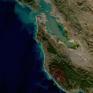
New research uses Landsat observations and advanced computing to chronicle wetlands lost (and found) around the globe.
Landsat satellites have been reliably returning images of Earth’s land surface for fifty years, providing novel insights about the planet we call home.
Despite the rapid melting of ice in many parts of Antarctica during the second half of the 20th century, researchers have found that the floating ice shelves which skirt the eastern Antarctic Peninsula have undergone sustained advance over the past 20 years.
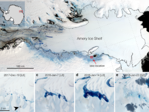
Satellites have helped show that strong tidal activity may facilitate water-induced fracturing, or hydrofracturing, where land ice transitions to floating ice shelf and cause the meltwater lake to drain quickly, often in as little as several days.
TRAINING RESOURCES Learning and Teaching about Earth from Space with NASA/USGS Landsat Satellites: A Trainer’s Toolbox The Landsat Educator Training Toolbox is a resource for educators
Have you ever hiked-up to the snowline in summer? Find out how Landsat is revealing how climate change is impacting some of our favorite places
Landsat data have helped to improve our understanding of Earth. Thanks to Landsat, today we have a better understanding of things as diverse as coral
Case Studies: How Landsat Helps Us In 1972, Stewart Udall—a former Secretary of the Interior and an original Landsat visionary—said, “I thought an Earth applications

Come along on a “roadtrip” through the decades to see how the technology on Landsat has evolved with the times to provide an unbroken data record.
The Harmonized Landsat Sentinel-2 dataset has been provisionally released. Come explore Landsat 8 and Sentinel-2 data… together.
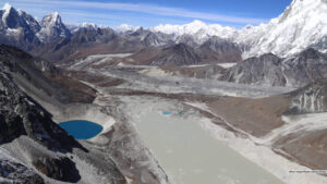
Using 30 years of Landsat data, researchers have found that the volume of glacial lakes worldwide has increased by about 50% since 1990.
Researchers and conservationists around the world are using data and images from NASA satellite instruments to manage and track living creatures of all kinds.
New time-lapse videos of Earth’s glaciers and ice sheets as seen from space are providing scientists with new insights into how the planet’s frozen regions are changing.
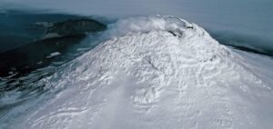
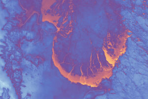
Landsat, Sentinel-2, and ASTER confirm a rare lava lake in Mt. Michael’s crater on the sub-Antarctic Saunders Island—a “remarkable geological feature.”
