Landsat Aids Discovery of Rare Lava Lake on Remote Sub-Antarctic Island
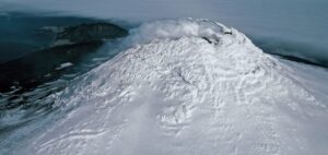
Landsat, Sentinel-2, and ASTER confirm a rare lava lake in Mt. Michael’s crater on the sub-Antarctic Saunders Island—a “remarkable geological feature.”

Landsat, Sentinel-2, and ASTER confirm a rare lava lake in Mt. Michael’s crater on the sub-Antarctic Saunders Island—a “remarkable geological feature.”
Seven ice features in western Antarctica have been named for Earth-observation satellites, including one named for Landsat.
In the long and winding history of the Landsat Program, April 15, 1999 was an important day.

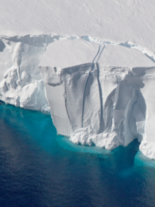
Iceberg A-68 calved from the Larsen C during a period of larger then average tidal cycles.
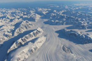
Multi-year comparison of Landsat images can unmask previously unknown geography.
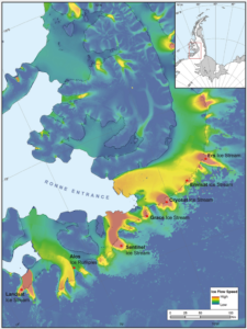
A NASA study based on an innovative technique for crunching torrents of satellite data provides the clearest picture yet of changes in Antarctic ice flow into the ocean.
Using Landsat 8’s thermal data to monitor calving events in Antarctica.
Montanaro and Gerace’s stray light “exorcism” has now placed the Landsat 8 thermal bands in-line with the accuracy of the previous (ghost-free) Landsat thermal instruments.
A NASA study has located the Antarctic glaciers that accelerated the fastest between 2008 and 2014 and finds that the most likely cause of their speedup is an observed influx of warm water into the bay where they’re located.
NASA Goddard research scientist Chris Shuman spoke recently to National Geographic about Delaware-sized iceberg that broke away from the Larsen C ice shelf last month.
The large rift that eventually formed iceberg A68 initially broke through a suture zone in the southern part of the ice shelf that had previously stabilized neighboring rifts for at least 80 years.
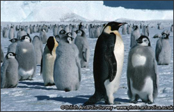
MAPPPD is the first free, open-access Antarctic decision support system that integrates remotely sensed inputs, such as Landsat 7 images and MODIS sea ice data, to provide an assessment of Adélie and other penguin species across the frozen continent.
Each day of 2017, a project called Landsat365 is sharing a stunning Landsat 8 image with the public.
Scientists are providing a near-real-time view of every large glacier and ice sheet on Earth with Landsat 8.
Over 375 presentations at this year’s AGU Fall feature Landsat.
Alex Gardner, a Research Scientist at NASA’s Jet Propulsion Laboratory, has used 30 years of Landsat data—some 3 million scenes—to measure the velocity of Antarctica’s ice sheet. He spoke with us about the work he is presenting at #AGU15.
Alex Burton-Johnson, Martin Black, and Peter Fretwell from the British Antarctic Survey have used Landsat 8 data to create a new rock outcrop map for Antarctica, which will become part of the Antarctic Digital Database. The team presented their research at #AGU15.
At this year’s AGU Fall meeting over 325 presentations feature research done using Landsat data. The Landsat-related papers and posters run the gamut of disciplines from cryosphere to biogeoscience to hydrology to global environmental change to natural hazards to informatics.
Landsat is a key data input for many products developed and used in water resources, agricultural monitoring, land use and land cover monitoring, forest management, and development planning.
An international team led by glaciologists from the University of Colorado Boulder and Trent University in Ontario, Canada has completed the first mapping of virtually all of the world’s glaciers—including their locations and sizes—allowing for calculations of their volumes and ongoing contributions to global sea rise as the world warms.
Landsat 8 is acquiring around 550 images per day – significantly more than the 400-image-per-day design requirement. Between Landsat 7 (launched in 1999 and still active) and Landsat 8, nearly 1,000 images per day are being collected. This is almost double the imagery collected three years ago, when Landsat 5 and 7 were operating together. The ability of Landsat 8 to image more frequently in persistently cloudy areas (e.g., humid tropics, high latitudes) is improving data collection in areas of critical importance for climate studies.
Agriculture, Forestry and Range Resources Land Use and Mapping Geology Hydrology Coastal Resources Environmental Monitoring Discriminating vegetative, crop and timber types Classifying land uses
On Nov. 18 USGS suspended Landsat 5 imaging activities in order to explore options for restoring satellite-to-ground image transmissions. It remains to be seen if
In 2000, NASA sponsored the creation of an orthorectified Landsat 7 mosaic of all of Earth’s landmasses (with the exception of Antarctica) as part of
