

Inbal Becker-Reshef
Director, NASA Harvest
Research Professor, University of Maryland
How do you use Landsat?
Landsat data plays a fundamental role in agricultural monitoring, providing Earth observation data that have been instrumental for understanding our agricultural systems and providing a long term data record that goes back 50 years, monitoring every field, continuously across the globe.
I use these data to monitor our agricultural lands and how they change from one week to the next, and from one season to the next. More specifically, I use Landsat data alongside other satellite and field data to map where and when crops like wheat are growing, to analyze different management practices including when crops are planted and harvested, to assess crop health and to forecast end of season yields. This type of information on our food supplies is important for both the public and private sectors to inform and address decisions on how we manage, grow and adapt our food production sustainably under a warming climate and with an increasing population.
What’s one Landsat image that is significant to you, and why?
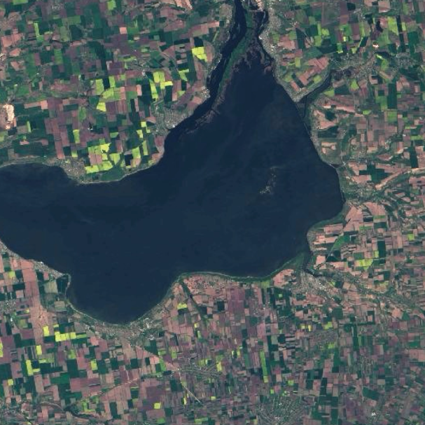
This is a Landsat 9 image taken on May 13, 2022, of Ukraine’s Kakhovka Reservoir, south of the city of Zaporizhia. Ukraine is one of the world’s breadbaskets and before the war was one of the world’s largest exporters of wheat, sunflower oil and corn.
The area in the image is in an important wheat and rapeseed producing region and is currently on the frontline of the war. This is an RGB image, which means that it shows reflectance in the visible range, similar to what we see with our eyes. The dark green fields are mostly winter wheat and the bright green/yellowish fields are flowering rapeseed fields. Fields that are brown were either recently planted with spring crops or fields that remained unplanted.
The current unfolding food crisis, due in large part to the war in Ukraine, highlights how fragile and interconnected our food system is and underscores the urgency for improved agricultural information. Data from satellites including Landsat are playing a critical role in helping to provide information to quantify the production of wheat and other crops, assess where fields have been left unplanted due to the war, and similarly, to quantify the area under wheat cultivation that will not be harvested.
Remote sensing gives us an ability to view and monitor our interconnected and constantly changing food systems, and often provide us with the only view of what is happening on the ground when ground access is not possible due to conflict or extreme weather.


