By Laura E.P. Rocchio
This afternoon at #AGU16, Dr. Rick Lawrence presented a poster on his work using a continuous mapping method to enable better forest management. Here is what he shared with us:
Presentation Title
Beyond Forest Classification: Continuous Mapping of Forest Species Composition, Mortality, and Sub-Canopy Using Landsat Imagery and Agnostic Analysis
What are the major findings of this research?
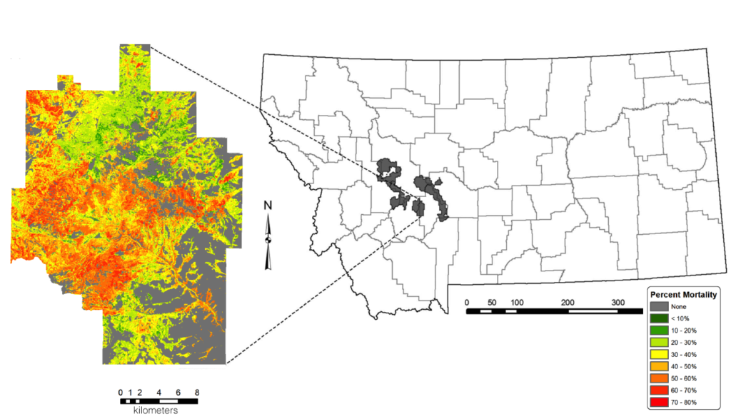
We were able to map (1) percent canopy cover of five different conifer species in mixed forest stands with mean errors of less than 4% between observed and predicted composition, depending on the species, (2) percent forest mortality with mean errors of less than 3%, and (3) post disturbance surviving sub-canopy composition by species with mean errors of five or less trees per Landsat pixel, depending on the species.
What are the implications of your findings?
This research moves us well beyond the traditional forest mapping approaches of mapping only dominant tree species and only presence or absence of mortality. This information is critical for forest managers, because, for example, often non-dominant forest species are critical for understanding the functioning of particular forests. Endangered Canada lynx, for example, respond to conditions where only 30% of the canopy consists of spruce and fir. Similarly, there are vastly different ecosystem effects between a forest that has experienced 50% mortality versus one that has experienced 100% mortality.
What insight did you gain from Landsat 8 that would have been impossible to glean otherwise?
We believe this type of continuous mapping of forest metrics at expansive scales would not have been possible without the excellent radiometric characteristics of Landsat 8, particularly the high level of quantization and the outstanding signal-to-noise ratio, which enables fine distinctions that were not previously possible. Modern machine-learning algorithms are able to exploit these sensor characteristics.
Do you foresee your methodology being used to evaluate Canada lynx habitat or to aid decision making aboutpost-beetle mortality harvesting?
We are carrying out this research in conjunction with Forest Service lynx experts, and the results of this research are currently being actively used both in northwest Montana and southern Colorado to evaluate lynx habitat, as well as for general forest planning purposes, as these data provide much more in-depth knowledge about the state of forest conditions than has previously been available to the forests in these regions.

Co-authors:
Shannon Savage
Montana State University
John Long
Northern State University
Emma Bode
Montana State University
John Squires
US Forest Service Rocky Mountain Research Station
Lucretia Olson
US Forest Service Rocky Mountain Research Station
This work was made possible by the USDA Forest Service, Joint Venture Agreement 12-CS-11221635-176, Agriculture and Food Research Initiative Competitive Grant 2013-68005-21298 from the USDA National Institute of Food and Agriculture, Grant/Cooperative Agreement 08HQGR0157 from the US Geological Survey (USGS) via a subaward from AmericaView, and the Montana Agricultural Experiment Station.
Anyone can freely download Landsat data from the USGS EarthExplorer or LandsatLook.
Further Reading:
+ Landsat Abounds at #AGU16


