Forest Disturbances and their Causes in California
Courtney Reents, a graduate student at University of Illinois at Urbana-Champaign, presented a poster on forest disturbance in California at #AGU15.

Courtney Reents, a graduate student at University of Illinois at Urbana-Champaign, presented a poster on forest disturbance in California at #AGU15.
Martin Goldhaber gave a talk about how climate change will impact the hydrochemistry of wetlands in an immensely important ecosystem known as the Prairie Pothole Region at #AGU15. Landsat data helped Goldhaber track how the size of the waterbodies in his study area changed between 1973 and 2011. Here’s what he shared with us about his research.
When you think of Southern Florida’s vast everglades, fire is not something that usually comes to mind, but the region has a long history of seasonal fires.
For those who live along its shores, Lake Tanganyika in east Africa is the backbone of local transportation and serves as an essential source of household water and protein. Every night, fishers lure nocturnal, sardine-like fish called dagaa with compression lamps that are strung between their boats. From the shore, the lake sparkles with the lights of miniature moons as people gather the treasured catch.
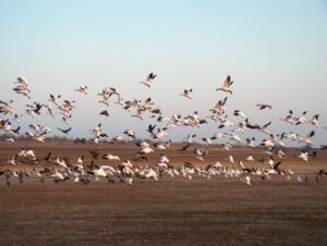
The BirdReturns program, created by The Nature Conservancy of California, is an effort to provide “pop-up habitats” for some of the millions of shorebirds, such as sandpipers and plovers, that migrate each year from their summer breeding grounds in Alaska and Canada to their winter habitats in California, Mexico, Central and South America.
![The sensors aboard Landsat 8 were designed to have higher sensitivity to brightness and color; they use 4,096 values to digitize their signals (12-bit data) whereas the last-generation sensor on Landsat 7 was slightly less sensitive and used only 256 data values (8-bits) to describe the range of brightness it recorded. Visually, this translates into a smoother, less noisy looking images as can been seen here when comparing these natural color Landsat 7 [left] and Landsat 8 [right] images of the extensive coral reefs on the northern shore of Vanua Levu, Fiji’s second largest island, acquired on September 19, 2002 and May 10, 2015, respectively.](https://landsat.gsfc.nasa.gov/wp-content/uploads/2015/06/Levu_Fiji_L8_sm-1-300x127.jpg)
With Earth-observing satellite data, scientists can now monitor the health of coral reefs, even in the most remote regions scattered around the globe where it is otherwise difficult to see changes.
In his lightning talk Lagomasino proposed a challenge to help study deforestation by linking satellite imagery and ground-images gathered via crowdsourcing
A pulse of water released down the lower reaches of the Colorado River last spring resulted in more than a 40 percent increase in green vegetation where the water flowed, as seen by the Landsat 8 satellite. The March 2014 release of water – an experimental flow implemented under a U.S.-Mexico agreement called “Minute 319” – reversed a 13-year decline in the greenness along the delta.
Ecosystems provide vast services and benefits to humankind: food and water that is needed for survival; nutrients and other natural products that fuel farms and industries; natural controls on many pests and pathogens; storage of carbon safely out of the atmosphere; shared spaces for tourism and recreation; and sanctuaries that preserve biodiversity, natural beauty, and cultural history.
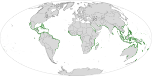
Along the sea’s edge in Bangladesh, India, Pakistan, and Sri Lanka, the dense coastal population lives largely in symbiosis with the region’s mangrove forests.
Mangroves—a vast network of intertidal trees and shrubs with their characteristic tangle of above ground roots—give safety, sustenance, and spectacle to coastal denizens in a multitude of ways. Namely, by stabilizing shorelines, safeguarding water quality, influencing stable microclimates, controlling flooding, and providing transportation, forest products, hunting and fishing grounds, and recreation and protecting people and property from storms.
Dr. Robert Anemone is the head of the Department of Anthropology at the University of North Carolina at Greensboro. But he works out of a pretty standard office. The administrative assistant greets you in the outer office before gesturing toward the next door.
A group of researchers from the University of Maryland, the Indonesian Ministry of Forestry, and the World Resource Institute joined forces to remedy the lack of consensus about the amount of old-growth forest clearing occurring in Indonesia.
Using Landsat time series data, a group of Australian and British ecologist have found that the Yellow Sea has lost 28% of its tidal flats in the last three decades.
Cold-sensitive mangrove forests have expanded dramatically along Florida’s Atlantic Coast since the mid-1980s, as the frequency of killing frosts has declined, according to a new study based on 28 years of satellite data from the NASA-USGS Landsat program.
Forest conservation is an issue of major concern to communities large and small around the globe. But gathering the monitoring data needed to make the right decisions has proven extremely prohibitive for individuals to entire governments.
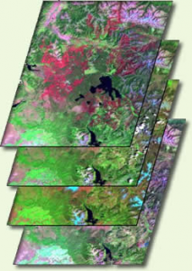
A new way of studying and visualizing Earth science data from a NASA and U.S. Geological Survey satellite program is resulting in, for the first
Over dinner on R.V. Calypso while anchored on the lee side of Glover’s Reef in Belize, Jacques Cousteau told Phil Dustan that he suspected humans were having a negative impact on coral reefs.
Have you ever walked along a California coast and wondered about all of the kelp washed-up on shore? In winter when storms are more frequent,
Kirtland’s warblers are an endangered species of lightweight little birds with bright yellow-bellies that summer in North America and winter in the Bahamas. But be
Trembling aspen are dying. No tree species in North America has a broader habitat and no other is as large (a single clone can be
In an article published this month in The International Journal of Avian Science,Spanish researchers used Landsat data to map waterbird habitat in rice paddies adjacent to
Scientists at UC Santa Barbara have developed new methods for studying how environmental factors and climate affect giant kelp forest ecosystems at unprecedented spatial and
If your summer travels have taken you across the Rocky Mountains, you’ve probably seen large swaths of reddish trees dotting otherwise green forests. While it
The most definitive map of Earth’s mangrove forests has been created with Landsat data. A group of scientists, led by Chandra Giri from USGS-EROS, has
Every spring, migratory birds like the Black-throated Blue Warbler journey from tropical Caribbean or South American refuges to North American forests. But which forest patch
Every year, hurricanes and droughts wreak havoc on human lives and property around the world. And according to a pair of new NASA-funded studies, migratory
NASA researchers studying urban landscapes have found that the intensity of the “heat island” created by a city depends on the ecosystem it replaced and
• John Smith’s Bay Then & Now – When Captain John Smith first explored the Chesapeake Bay in 1607, the “Great Shellfish Bay,” as it
Source: Minister for Primary Industries and Fisheries, Australia Queensland scientists are using satellite technology to help manage one of Australia’s most damaging weeds. “This a
Every summer in New Zealand, recreational swimming in Okawa Bay is often prohibited because of toxic algal blooms. According to a Jan. 20 article in
Detailed global coral reef maps created with Landsat 7 imagery have enabled scientists to determine which reefs have adequate protection. It is well documented that
