Sensing Forest Disturbance: Landsat Sees Insect Outbreaks From Space
A new way of studying and visualizing Earth science data from a NASA and U.S. Geological Survey satellite program is resulting in, for the first

A new way of studying and visualizing Earth science data from a NASA and U.S. Geological Survey satellite program is resulting in, for the first
A new method of mapping satellite data reveals the hidden stories of forests in the Pacific Northwest. Forests in the United States are constantly changing.
A combination of lightning, drought and human activity caused fires to scorch more than one-third of Yellowstone National Park in the summer of 1988. Within
• NASA’s Earth-observing fleet of satellites provides a worldwide and unbiased view with standardized scientific data—information crucial for tracking the health of the world’s forests.
Part of the challenge for understanding how forests are affected by climate change is the need for long-term data. Satellites are a cost-effective way to
Satellite researcher Alan Belward works for the Institute for Environment and Sustainability, part of the European Commission’s Joint Research Center in Ispra, Italy. Dr. Belward
Kirtland’s warblers are an endangered species of lightweight little birds with bright yellow-bellies that summer in North America and winter in the Bahamas. But be
Trembling aspen are dying. No tree species in North America has a broader habitat and no other is as large (a single clone can be
Contributor: Vicky Fakan, USAID USAID has long been a major actor helping to conserve Guinea’s forest reserves, which replenish many of West Africa’s life-sustaining waterways. Now,
Contributor: Melissa Quijada, NASA Goddard Space Flight Center NASA satellite images regularly map active fires around the world. Once a fire is out, satellite data and
Source: Jan Nelson, USGS / Rob Gutro, NASA Goddard Space Flight Center The second largest fire in Arizona history, the Wallow Fire is graphically depicted
Contributors: Janet L. Anderson, NASA Marshall Space Flight Center In the last few years, fire incidence in Guatemala has increased, damaging and transforming wild areas
Source: Elizabeth Braun, Woods Hole Research Center The Woods Hole Research Center has released the first hectare-scale maps of canopy height, aboveground biomass, and associated
In an article released late this month in Environmental Research Letters, authors Mark Broich, Matthew Hansen, Fred Stolle, Peter Potapov, Belinda Arunarwati Margono, and Bernard Adusei
At the UN climate talks in Cancun, a satellite-based protocol to track deforestation is being met with some optimism. In this new initiative to incentivize
In a recent EarthSky interview, Landsat science team member Curtis Woodcock talks about the importance of Landsat data to global forest monitoring. Podcasts: • 90 second
Matt Hansen, the co-director of South Dakota State University’s Geographic Information Science Center for Excellency, spoke with Mongabay.com about the importance of Landsat data to forest cover
Source: Louis Bergeron, Stanford Report A new study led by a Stanford researcher shows that more than 80 percent of the new farmland created in the
Contributor: Gretchen Cook-Anderson, NASA‘s Earth Science News Team Countless people clung to life in the branches of trees hemming the shorelines during the deadly 2004 tsunami
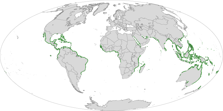
The most definitive map of Earth’s mangrove forests has been created with Landsat data. A group of scientists, led by Chandra Giri from USGS-EROS, has
A team of researchers led by Landsat Science Team member Eileen Helmer has used Landsat time series data to map forest height on the island
A single, huge, violent storm that swept across the whole Amazon forest in 2005 killed half a billion trees, according to a new study funded
• A recently published Nature Geoscience article by Ruth DeFries et al. reveals that urban pressures (for food and resources) have replaced subsistence farmers as the leading
During the devastating 2004 Indian Ocean tsunami, more than 200,000 people lost their lives. Some coastal communities were shielded from the waves’ destruction by mangrove
Source: Rebecca Lindsey; NASA Earth Observatory At the Global Land Cover Facility at the University of Maryland-College Park, the computers are in training. For the past
Brazil’s space agency, the National Institute for Space Research (INPE), has reported the lowest rate (km²/yr) of deforestation in the Brazilian Amazon since 1988 when
On Indonesia’s island of Sumatra a large expanse of tropical rainforest, known as the Leuser Ecosystem, is home to many endangered species of plants and
Source: Group on Earth Observations “The only way to measure forests efficiently is from space,” Group on Earth Observations (GEO) director, José Achache said referring to
by: Gretchen Cook-Anderson, NASA Earth Science News Team Impoverished fishermen along the coast of tropical African countries like Mozambique and Madagascar may have only a
Source: U.S. Forest Service As members of the forest products industry continue to reduce their landholdings, monitoring reliable future timber supplies becomes an increasingly important issue.
In a recent study published in Remote Sensing of Environment, Landsat science team member James Vogelmann and colleagues have used Landsat data collected between 1988 and 2006 to
Source: Gretchen Cook-Anderson In the last decade, Asian farmers have cleared tens of thousands of square miles of forests to accommodate the world’s growing demand
Contributor: Eileen Helmer In a study published today, carbon accumulation rates of tropical forests biomass regrowth in areas of abandoned agriculture have been measured entirely
