Category: Technical Information

News Archive

Landsat Looks to the Moon

Every full moon, Landsat 8 turns its back on Earth. As the satellite’s orbit takes it to the nighttime side of the planet, Landsat 8 pivots to point at the moon. It scans the distant lunar surface multiple times, then flips back around to continue its task of collecting land-cover information of the sunny side of Earth below. These monthly lunar scans are key to ensuring the land-imaging instrument aboard Landsat 8 is detecting light consistently. For a well-known and stable source of light, nothing on our planet beats the moon, which lacks an atmosphere and has an unchanging surface, barring the odd meteorite.
Read More »

John Parr Snyder's Space Oblique Mercator Projection

To continually map the Earth’s surface using Landsat data, an entirely new projection had to be created. This new projection was created by John Parr Snyder and is known as the Space Oblique Mercator (SOM) projection. It is considered, “one of the most complex projections ever devised” according to cartographic historian, John W. Hessler.

Read More »

The Thematic Mapper

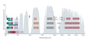
The Thematic Mapper (TM) is an advanced, multispectral scanning, Earth resources sensor designed to achieve higher image resolution, sharper spectral separation, improved geometric fidelity and

Read More »

The Multispectral Scanner System

MSS Relative Spectral Response > The Multispectral Scanner System (MSS) sensors were line scanning devices observing the Earth perpendicular to the orbital track. The cross-track

Read More »

The Enhanced Thematic Mapper Plus

The Enhanced Thematic Mapper Plus (ETM+) instrument is a fixed “whisk-broom”, eight-band, multispectral scanning radiometer capable of providing high-resolution imaging information of the Earth’s surface.

Read More »

Landsat 7

The Details Launch Date: April 15, 1999 Status: operational despite Scan Line Corrector (SLC) failure May 31, 2003 Sensors: ETM+ Altitude: 705 km Inclination: 98.2° Orbit: polar, sun-synchronous Equatorial Crossing Time: nominally

Read More »

Landsat 6

The Details Launch Date: October 5, 1993 Status: lost at launch Sensor: ETM + read about the history of Landsat 6 More Technical Details Landsat 1 Landsat 2 Landsat

Read More »

Landsat 5

The Details Launch Date: March 1, 1984 Status: Decommissioned January 2013 Sensors: TM, MSS Altitude: 705 km Inclination: 98.2° Orbit: polar, sun-synchronous Equatorial Crossing Time: nominally 9:45 AM (± 15 min.) local

Read More »

Landsat 4

The Details Launch Date: July 16 , 1982 Status: decommissioned, June 15, 2001 Sensors: TM, MSS Altitude: 705 km Inclination: 98.2° Orbit: polar, sun-synchronous Equatorial Crossing Time: nominally 9:45 AM (± 15 min.)

Read More »

Landsat 3

The Details Launch Date: March 5, 1978 Status: put into standby mode: March 31, 1983; decommissioned: Sept. 7, 1983 Sensors: RBV, MSS Altitude: nominally 900 km Inclination: 99.2° Orbit: polar, sun-synchronous Equatorial

Read More »

Landsat 2

The Details Launch Date: January 22, 1975 Status: removed from operational status: February 5, 1982; decommissioned: July 27, 1983 Sensors: RBV, MSS Altitude: nominally 900 km Inclination: 99.2° Orbit: polar, sun-synchronous Equatorial

Read More »

Landsat 1

The Details Launch Date: July 23, 1972 Status: expired, January 6, 1978 Sensors: RBV, MSS Altitude: nominally 900 km Inclination: 99.2° Orbit: polar, sun-synchronous Equatorial Crossing Time: nominally 9:42 AM mean local time

Read More »