
By Ashley Balzer, NASA’s Goddard Space Flight Center
Scientists have known for decades that climate change makes wildfires more common, larger, and more intense. Now an international team of scientists has demonstrated a new connection between fires and global warming. Using data from Landsat satellites, they discovered that wildfires in the western United States have been spreading to higher elevations over the past few decades due to warmer and drier conditions that are clearly linked to climate change.
“Our research would not have been possible if it weren’t for decades of reliable Landsat data to help us look back in time,” said Mohammad Reza Alizadeh, a research assistant at McGill University who led the study. “We hope these findings will encourage people to not only mitigate the effects of increased wildfire activity, but also to limit emissions and curb global warming.”
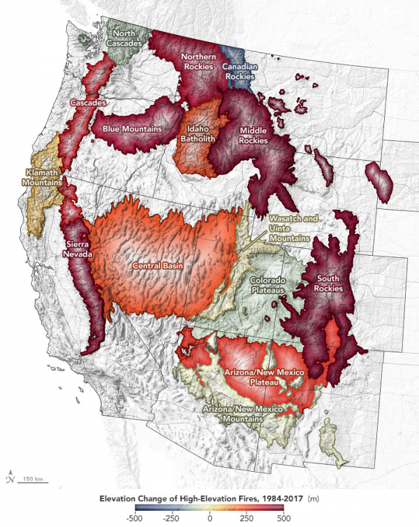
Historically, forest fires have been rare in high-elevation areas — at least 8,200 feet (2,500 meters) above sea level. But when Alizadeh and co-authors studied fires that occurred between 1984 and 2017, they found fires were moving to higher ground at a rate of 25 feet (7.6 meters) per year.
The fires are rising up hillsides and mountainsides because areas that used to be too wet to burn are now drier due to warmer temperatures and earlier snowmelt. The study also showed that climate aridity – particularly air that renders vegetation dry enough to burn – is moving upward at a similar rate of about 29 feet (8.9 meters) each year. The team estimates that an additional 31,500 square miles (81,500 square kilometers) of the mountainous US West are now more vulnerable to fires compared to 1984.
The map above illustrates where and how much fires have moved upslope in the western United States since 1984, according to Alizadeh et al. Shades of yellow, orange, and red show the intensity of the elevation gain by mountain range.
To evaluate fire characteristics in high-elevation regions, the researchers combined two Landsat-derived data sets – one that showed the locations of moderate to severe fires and one that displayed forest cover – with a digital elevation model. By overlaying this data, the team was able to analyze trends in forest fire elevation for different regions that have similar ecological traits. They compared their findings with measurements of how dry the climate is and found a strong link between aridity and both the elevation and size of forest fires.
The impacts of the changes are numerous.
Many high-elevation territories serve as the “water towers” for the western US; that is, snow accumulates each winter and then melts and runs down to river valleys as a summer water source. Fires can change how snow accumulates and melts, shifting when it is available in downstream reservoirs and rivers. That’s a problem for more than 60 million people in the western US who rely on this water source. Fire debris, ash, and chemical retardants also can pollute the water, reducing its quality for drinking.
High-elevation fires are also bad news for species native to those areas because the much of the plant life is not fire-adapted and may grow back differently, as a 2020 paper suggested. Streams near high-elevation fires are also much warmer than those in similar areas that haven’t experienced fires. Both conditions threaten native animals and plants that depend on cooler water and air. This could lead to extinctions.
Finally, many towns and cities located at high elevations are not necessarily accustomed to the threat of wildfires. “Areas in Canada and the western U.S. are experiencing droughts and heat waves, which increase the risk of fires,” said Mojtaba Sadegh, an assistant professor at Boise State University and a co-author of the paper. “This should raise the alarm for people to think more about what the future will look like if global warming continues at the same rate.”
“Moving forward, we can implement adapted forest management practices, create more fire-resilient communities, and use tactics like controlled burns,” Sadegh said. “But because the root cause is climate change, the most important path forward is to prevent further degradation and warming, which requires both individual and collective action.”
Reference:
Alizadeh, Mohammad Reza, John T. Abatzoglou, Charles H. Luce, Jan F. Adamowski, Arvin Farid, and Mojtaba Sadegh. 2021. “Warming enabled upslope advance in western US forest fires.” Proceedings of the National Academy of Sciences 118 (22):e2009717118. doi: 10.1073/pnas.2009717118.


