Decline of the Last Glaciers in the Eastern Tropics

Decline of the Last Glaciers in the Eastern Tropics

Punak Jaya glacier
Punak Jaya contains the last remaining tropical glaciers in East Asia. Photo credit: Olof Sundström & Martin Letzter
This afternoon at #AGU16, Andrew Klein, a Geography professor at Texas A & M University, presented a poster on the continued decline of the last glaciers in the eastern tropics. We spoke briefly with Dr. Klein:
Presentation Title
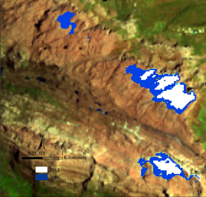
Satellite measurements of glacier recession on Punak Jaya, Papua Province, Indonesia, from 2006 to 2015
What are the major findings of this research?
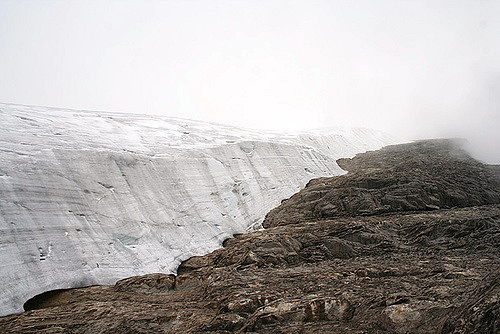
The major findings are that the glaciers of Puncak Jaya have continued their decline that probably began in the 1850s. At their current rate of decline, there is a good possibility they will disappear in the next 20 years.
What are the implications of your findings?
Glacier recession continues in the tropics—these happen to be the last glaciers in the eastern tropics.
What insight did you gain from Landsat that would have been impossible to glean otherwise?
Landsat provides a global view of the the worlds alpine glaciers and enables us to track their retreat in ways that would be difficult without this important environmental time series.
How would the potential disappearance of all Puncak Jaya glaciers affect the region?
Fortunately, the impact will be limited given their small size and the fact that they do not represent a significant water resource.
 
Ice loss of the Puncak Jaya glaciers
Ice loss of the Puncak Jaya glaciers from 2006 to 2015. The base image is a Landsat 8 scene acquired on October 13, 2015.

Co-authors:
Xian Dong
Texas A&M University College Station
Joni L Kincaid
Texas A & M University
 
 
Anyone can freely download Landsat data from the USGS EarthExplorer or LandsatLook.
Further Reading:
+ Landsat Abounds at #AGU16

Get the latest from Landsat in your inbox.


By submitting this form, you are consenting to receive marketing emails from: Landsat Science. You can revoke your consent to receive emails at any time by using the SafeUnsubscribe® link, found at the bottom of every email. Emails are serviced by Constant Contact
On Key

Recent Posts

Map shows South Korea with waterways highlighted. In the top right corner is a north arrow and in the bottom left corner is a legend of different rivers in South Korea.

Monitoring Water Quality in South Korea

South Korea is facing a water quality problem. Researchers Hyunglok Kim and Seongjun Lee from the Gwangju Institute of Science and Technology (GIST) embarked on developing a model to predict water quality indicators in near real-time.

Read More »
Landsat outreach specialist Allison Nussbaum and GEDI/UMD Faculty Specialist Talia Schwelling hold Landsat/GEDI postcards at the NASA exhibit booth at AGU24.

Landsat at AGU24

The NASA Landsat Science and Outreach teams attended the American Geophysical Union’s annual meeting in DC in December. At AGU24, they shared research and educated the public about Landsat.

Read More »
On Key

Related Posts

Map shows South Korea with waterways highlighted. In the top right corner is a north arrow and in the bottom left corner is a legend of different rivers in South Korea.

Monitoring Water Quality in South Korea

South Korea is facing a water quality problem. Researchers Hyunglok Kim and Seongjun Lee from the Gwangju Institute of Science and Technology (GIST) embarked on developing a model to predict water quality indicators in near real-time.

Read More »
Landsat outreach specialist Allison Nussbaum and GEDI/UMD Faculty Specialist Talia Schwelling hold Landsat/GEDI postcards at the NASA exhibit booth at AGU24.

Landsat at AGU24

The NASA Landsat Science and Outreach teams attended the American Geophysical Union’s annual meeting in DC in December. At AGU24, they shared research and educated the public about Landsat.

Read More »