Menu
Source: Earth Resources Technology Satellite Reference Manual

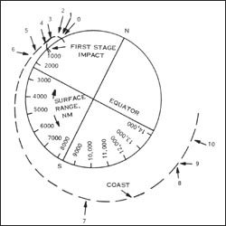
Diagram showing the flight profile of ERTS-1.
This schematic appears in the ERTS Reference Manual that was prepared by General Electric prior to the Landsat 1 (ERTS-1) launch in 1972.
The schematic shows the Landsat 1 flight profile, from liftoff (0) to spacecraft separation (10).
The manual tells us, “an all-inertial guidance system, consisting of an inertial sensor package and guidance computer, controls the vehicle and sequence of operations from liftoff to spacecraft separation. The flight profile is presented in [this figure] .”


