Mapping major geologic features

Mapping major geologic features

Location: Harrisburg, Pennsylvania
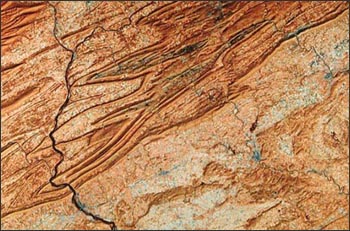
Landsat TM image of the Harrisburg region acquired on Oct. 30, 1984.

This Landsat view shows Harrisburg and the Appalachian Mountains of central Pennsylvania. The Piedmont province is visible in the lower right corner. The Great Valley runs SW-NE across the center of view, and the Valley and Ridge province occupies the northwest portion of scene. The city of Harrisburg is the blue-grey patch next to the Susquehanna River in the lower left corner.

 
On Key

Recent Posts

Spectral Characterization

The measured wavelength locations of the ETM+ spectral bands are compared to Landat 5’s TM in Table 8.1 The spectral bandwidths are determined by the combined response of all optical

Read More »
On Key

Related Posts