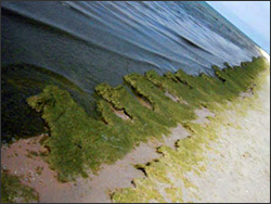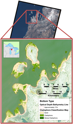
A depth-invariant algorithm developed at the Michigan Tech Research Institute (MTRI) has been used successfully with satellite imagery to map Cladophora on the bottom of Lake Michigan under NASA funding. Under a Great Lakes Restoration Initiative (GLRI) grant, MTRI is mapping the near-shore extent of Cladophora for Lakes Michigan, Huron, Erie and Ontario (Cladophora is not yet a significant issue in colder Lake Superior).
MTRI generated a Satellite-Derived Lake Michigan Macro-algae Map under the Great Lakes Restoration Initiative (GLRI) funding (award no. GL-00E00561-0), which represents the extent of macro-algae (MAL) and submerged aquatic vegetation (SAV) in the optically shallow areas of Lake Michigan (areas where there is a return of light from the bottom). The MAL/SAV is predominantly Cladophora, with localized areas of macrophytes, Chara, and diatoms.

The map, which has a 30 meter resolution, was generated using a MTRI-developed depth-invariant algorithm, and utilized Landsat satellite data from 2008-2011 collected during the vegetative growing season (April-May). The total area of optically shallow water mapped is approximately 4,210 square kilometers of which 1,024 square kilometers or 24% is mapped as MAL/SAV. The wet weight biomass of the MAL/SAV is estimated at a conservative weight of 375,000 metric tons, using an area-weighted average dry weight of 36 g/meter².
Cladophora extent has been successfully mapped in the nearshore using Landsat 5 and 7 imagery in addition to commercial satellite imagery. Moreover, Landsat satellites offer a near-nadir, consistent viewing geometry that is helpful for Cladophora mapping. The historical archive offered by Landsat is longer than any commercial satellites, allowing for long-term time series analysis of Cladophora growth. Landsat is the best compromise between cost and resolution for this analysis. Continued support from existing and future Landsat missions is essential for this and other Great Lakes research programs.
Source: Michigan Tech Research Institute
Further information:
+ Great Lakes Cladophora Mapping
+ Interactive Satellite-Derived Lake Michigan Submerged Aquatic Vegetation Map
+ Algal (Cladophora) Mats Harbor High Concentrations of Indicator Bacteria and Pathogens


