
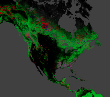
The maps resulting from the study are the first to document forest loss and gain using a consistent method around the globe, at high resolution. They allow scientists to compare forest changes in different countries and monitor annual deforestation. With each pixel in a Landsat image showing an area about the size of a baseball diamond, researchers see enough detail to tell local, regional and global stories.
“Now, we have 12 years of annual forest loss over the globe,” said Matthew Hansen, whose team at the University of Maryland in College Park, Md., led the new study.
Hansen and colleagues analyzed 143 billion pixels in 654,000 Landsat images to compile maps of forest loss and gain between 2000 and 2012. During that period, 888,000 square miles (2.3 million square kilometers) of forest were lost, and 309,000 square miles (800,000 square kilometers) regrew. The researchers, including scientists from the University of Maryland, Google, the State University of New York, Woods Hole Research Center, the U.S. Geological Survey (USGS) and South Dakota State University, published their work in the Nov. 15 issue of the journal Science.
Source: Steve Cole and Kate Ramsayer, NASA
Tune in next Monday, November 18 at 1 p.m. ET to a live-streamed, online presentation and demonstration by Matt Hansen and colleagues from UMD, Google, USGS, NASA and the Moore Foundation.
Link to live-streamed event: http://goo.gl/JbWWTk
Please submit questions here: http://goo.gl/rhxK5X
Further Information:
+ High-Resolution Global Maps of 21st-Century Forest Cover Change, Science
+ NASA-USGS Landsat Data Yield Best View to Date of Global Forest Losses, Gains, NASA
+ Changes in World’s Forests Portrayed in High Definition, USGS
+ The first detailed maps of global forest change, Research at Google
+ Incredible High-Resolution Interactive Map of the World’s Shrinking Forests, Wired
+ When Trees Fall, Landsat Maps Them, NASA (via YouTube)

Be Part of What’s Next: Emerging Applications of Landsat at AGU24
Anyone making innovative use of Landsat data to meet societal needs today and during coming decades is encouraged to submit and abstract for the upcoming “Emerging Science Applications of Landsat” session at AGU24.


