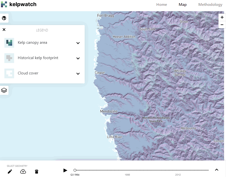
The Nature Conservancy, Woods Hole Oceanographic Institution, University of California, Los Angeles (UCLA), and University of California, Santa Barbara (UCSB) have launched Kelpwatch.org, the world’s largest map of kelp forest canopy in both time and space extending from Baja California, Mexico, to the Oregon-Washington State border seasonally from 1984–2021.
A groundbreaking open-source web tool, Kelpwatch.org harnesses the power of machine learning and cutting-edge remote sensing science to analyze nearly 40 years of Landsat satellite data and interactively display kelp forest canopy. Kelpwatch.org users can select a region, time frame and seasons of interest to animate the changes in kelp canopy over time and freely download data.
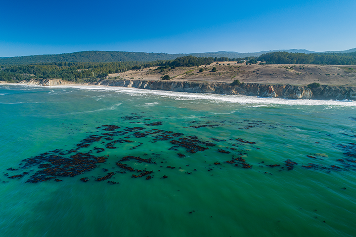
The web tool has been launched amid historic and sustained declines in many kelp forest ecosystems, which provide crucial services to both people and nature. Changing ocean conditions including marine heatwaves linked to climate change have precipitated the loss of kelp in many regions around the world, with further declines anticipated in response to ocean warming.
“Kelp forests are home to thousands of species, locally mitigate the effects of ocean acidification and provide valuable services for coastal communities,” said Vienna Saccomanno, an ocean scientist with The Nature Conservancy who leads the group’s Kelp Mapping and Monitoring Program. “Knowing where remaining healthy kelp forests are located and the long-term history of kelp forests is the first step in strategic restoration. Kelpwatch.org provides this information and is a game-changer for resetting the ecosystem.”
Prior to Kelpwatch.org, the lack of historical data on trends and changes in kelp forest abundance across large areas was a key challenge for researchers, as well as state agencies tasked with managing this important resource. The web tool and its data already have been used to inform the California Department of Fish and Wildlife (CDFW)’s Enhanced Status Report for giant and bull kelp, as well as the early planning stages of developing the Kelp Restoration and Management Plan.
“Kelpwatch.org provides a unique platform to visualize kelp canopy extent and download the corresponding data all in one place,” said Dr. Kristen Elsmore, an environmental scientist at CDFW. “The interactive features are particularly useful for preliminary evaluation of kelp within a given management area and exploration of potential sites for kelp restoration pilot projects. As a tool accessible to both the public and to resource managers, Kelpwatch.org can provide a central platform for data transparency and communication.”
The web tool has also been used to catalyze scientific research by leading experts investigating the health of kelp forests in a changing ocean.
“We have found Kelpwatch.org to be invaluable for documenting regional patterns of kelp dynamics, especially for assessing the consequences and patterns of recovery from sea urchin outbreaks that followed the 2013 seastar wasting disease and the 2014–2016 marine heatwave,” said Dr. Mark Carr, a professor of marine ecology at the University of California, Santa Cruz. “It has been both a valuable research tool and for conveying the patterns of kelp loss to others.”
Drs. Tom Bell and Kyle Cavanaugh pioneered the technique to map kelp forest density from Landsat satellite imagery and, in 2019, initiated a collaboration with The Nature Conservancy in California to create an online visualization tool to improve kelp forest mapping and monitoring.
“The Landsat satellite program has provided images of the earth’s surface for more than 40 years, and so it is ideal for documenting long-term changes in ecosystems such as giant kelp forests,” said Dr. Cavanaugh, an associate professor in geography at UCLA. “We’ve developed new methods to process this enormous dataset to turn the imagery into maps of kelp canopy, and Kelpwatch.org provides an ideal platform to access and analyze these maps.”
Using the tool to conduct flagship analyses on kelp dynamics along the west coast of the U.S. in response to the 2014–2016 record-breaking marine heatwave, the Kelpwatch.org team discovered an unprecedented and worsening collapse of kelp forests around the Monterey Peninsula, an iconic kelp-dominated stretch of California’s coast. While the loss around Monterey and elsewhere in the state is alarming, efforts to restore kelp forests are taking place in the places hardest hit like the North Coast; the team also found reasons for hope with the rapid recovery of kelp canopy cover in Bahía Tortugas, Baja California Sur that showed complete and sustained recovery from the marine heat wave since 2018.
Funded by a multi-year grant from NASA’s Ocean Biology and Biochemistry program, the team plans to expand the tool to new geographies around the world where kelp forests are found, including Washington State, British Columbia, Southeast Alaska, the Falkland Islands, Chile, Tasmania and Australia.
“The large spatial coverage of Kelpwatch.org paired with decades of historical data allow ecosystem managers and the public to examine how changes to kelp forests in their locations of interest compare to the past four decades,” said Dr. Tom Bell, a scientist at Woods Hole Oceanographic Institution. “Kelp forests are incredibly dynamic systems, so having access to historical data gives anyone the power to determine if recent changes lie outside the range of natural variability.”
Users can access this tool and view kelp forest dynamics at Kelpwatch.org.