Landsat's Role in Responding to Disasters
In 2022, the Emergency Events Database (EM-DAT) reported 387 natural hazards and disasters worldwide, resulting in the loss of over 30,000 lives and affecting more than 185 million individuals. Economic losses totaled around US$223.8 billion. Fires, floods, heat waves, drought, hurricanes, tornadoes, and other natural disasters can be particularly tragic and costly when critical facilities such as power plants, airports, roads, and hospitals are threatened. When a disaster strikes, remote sensing is often the only way to get a big-picture view of what is happening on the ground. With its consistent, reliable, repeated observations of Earth’s changing surface, Landsat keeps a record of Earth’s land surfaces before and after disasters, serving as an essential tool for assessing risk, mapping the extent of damage, and planning post-disaster recovery. Landsat produces 185-kilometer-wide images with 30-meter resolution in visible and infrared wavelengths of light, making it possible to map impacts on the landscape in ways otherwise not visible to human sight. For example, Landsat sensors enable us to see the heat from fires both during and after the burns, and the lava flows from volcanic eruptions even when gaseous substances obscure the view to human eyes.
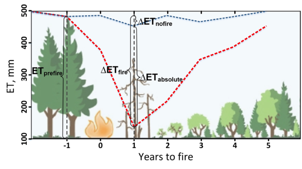
Understanding How Fire Alters the Water Use of Sierra Nevada Forests
Fires play an important role in regulating forest density, vegetation water use, and runoff.
USGS Burned Area Products Group in Denver Touts Value of Landsat ARD
A new Burned Area algorithm has been developed by USGS to identify burned areas in images across the Landsat archive.
Avalanches Becoming More Frequent and Powerful in Alaska, Landsat Shows
As global temperatures rise, melting permafrost is expected to cause more frequent and hazardous landslides.
Assessing the Impact of Hurricanes on Puerto Rico’s Forests
Scientists at Berkeley Lab have produced a rapid mapping of the disturbance intensity across Puerto Rico’s forests with the help of Google Earth Engine and Landsat 8.
Near Real Time Monitoring of Volcanic Eruptions
Using Earth Observation data to monitor volcanic eruptions.
Puerto Rico Landscape Ravaged by Hurricane Maria
Hurricane Maria tore across Puerto Rico on September 20, 2017, ravaging both urban and rural areas with category 4 winds and intense rainfall for several days.