
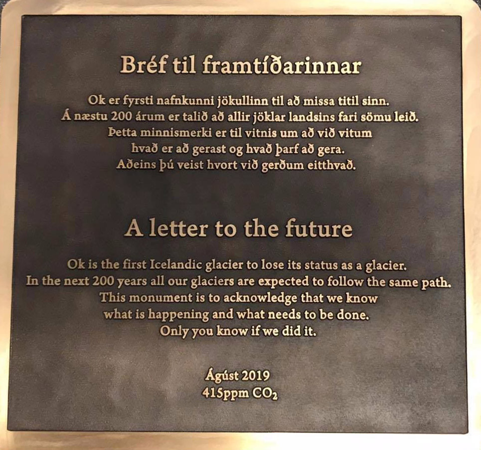
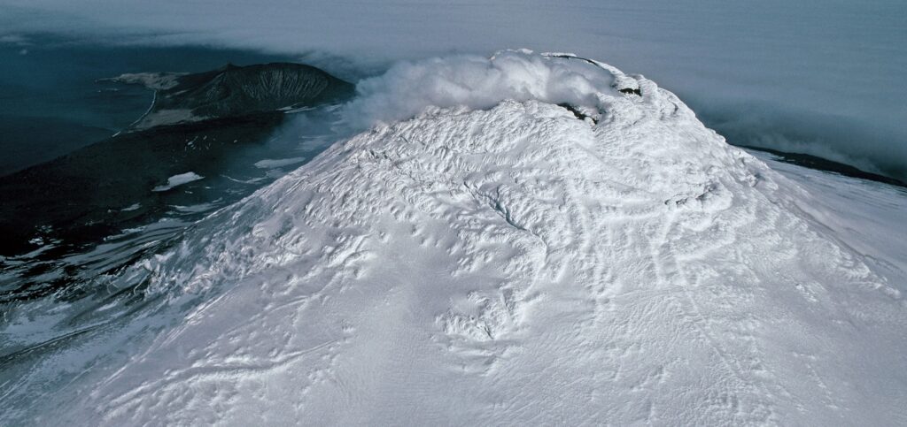
Tribute to a Glacier That Is No More
A memorial was placed on top of the volcano where Okjökull Glacier’s ice once flowed.
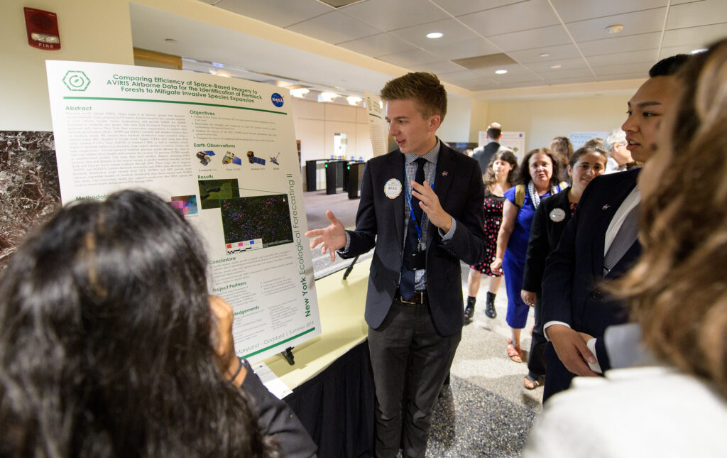
Applying Earth Observations to Real-World Concerns
Summer projects focused on using Earth science data for practical applications like agriculture and food security, disasters, ecological forecasting, energy, health and air quality, transportation and infrastructure, urban development and water resources.
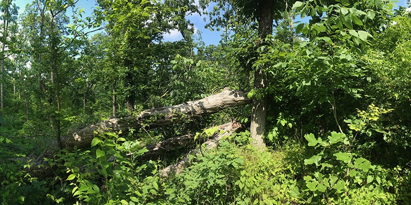
Tornadoes, Windstorms Pave Way for Lasting Plant Invasions
Landsat shows that large blowdown areas in southern Illinois forests are more heavily invaded by invasive species and slower to recover than smaller areas after a tornado.
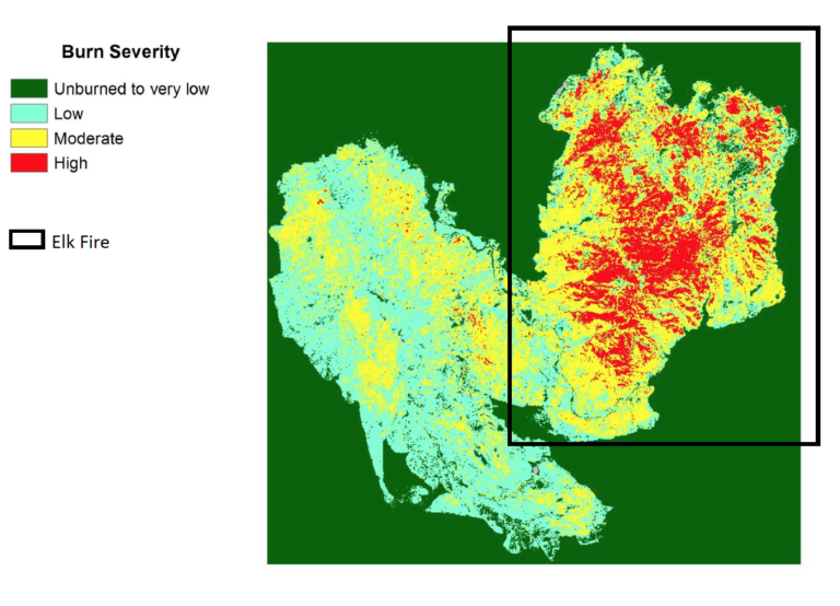
Landsat Can Save Federal Agencies up to $7.7 Million Annually in Post-Fire Costs
Using satellite imagery is a cost-effective way to assess burned areas and triage mitigation measures post-wildfire, study found. Federal agencies can save as much as $7.7 million annually in post-fire costs by using Landsat.
Landsat Aids Discovery of Rare Lava Lake on Remote Sub-Antarctic Island
Landsat, Sentinel-2, and ASTER confirm a rare lava lake in Mt. Michael’s crater on the sub-Antarctic Saunders Island—a “remarkable geological feature.”
More than Naught: The “Z” of Where Land Meets Sea
Harnessing 30 years of Landsat data, a team of researchers from Australia has created the first 3D model of Australia’s entire coastline.
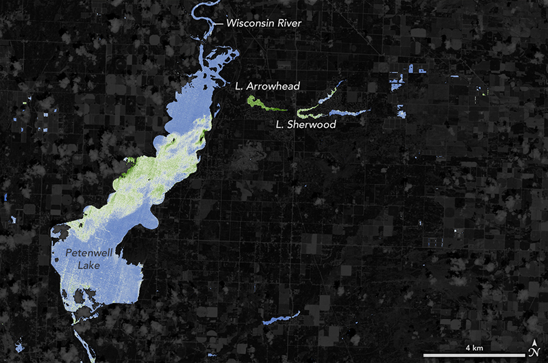
NASA Helps Warn of Harmful Algal Blooms in Lakes, Reservoirs
With limited resources to dedicate to monitoring for harmful algal blooms, water managers are looking to new technologies from NASA and its partners to detect and monitor potential hazards in lakes and reservoirs.
Advisory Panel Recommends Landsat Data Stay Free
Keeping Landsat data free and open is the right path forward, a federal advisory panel has concluded.
Landsat Can Save Federal Agencies up to $7.7 Million Annually in Post-Fire Costs
Using satellite imagery is a cost-effective way to assess burned areas and triage mitigation measures post-wildfire, study found. Federal agencies can save as much as $7.7 million annually in post-fire costs by using Landsat.
Landsat Aids Discovery of Rare Lava Lake on Remote Sub-Antarctic Island
Landsat, Sentinel-2, and ASTER confirm a rare lava lake in Mt. Michael’s crater on the sub-Antarctic Saunders Island—a “remarkable geological feature.”
More than Naught: The “Z” of Where Land Meets Sea
Harnessing 30 years of Landsat data, a team of researchers from Australia has created the first 3D model of Australia’s entire coastline.
NASA Helps Warn of Harmful Algal Blooms in Lakes, Reservoirs
With limited resources to dedicate to monitoring for harmful algal blooms, water managers are looking to new technologies from NASA and its partners to detect and monitor potential hazards in lakes and reservoirs.
Advisory Panel Recommends Landsat Data Stay Free
Keeping Landsat data free and open is the right path forward, a federal advisory panel has concluded.
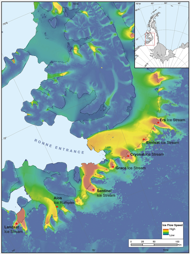
Introducing Landsat Ice Stream
Seven ice features in western Antarctica have been named for Earth-observation satellites, including one named for Landsat.

RIT Scientists Recognized for Solving Issue with Landsat 8 TIRS Instrument
Aaron Gerace and Matthew Montanaro earned the 2019 USGIF Academic Achievement Award for their work on the Landsat 8 TIRS stray-light issue.

Landsat Science Team Member Feng Gao Wins 2018 Arthur S. Flemming Award
Dr. Gao has been awarded in recognition of his original research in the application of remote sensing for crop and vegetation monitoring.
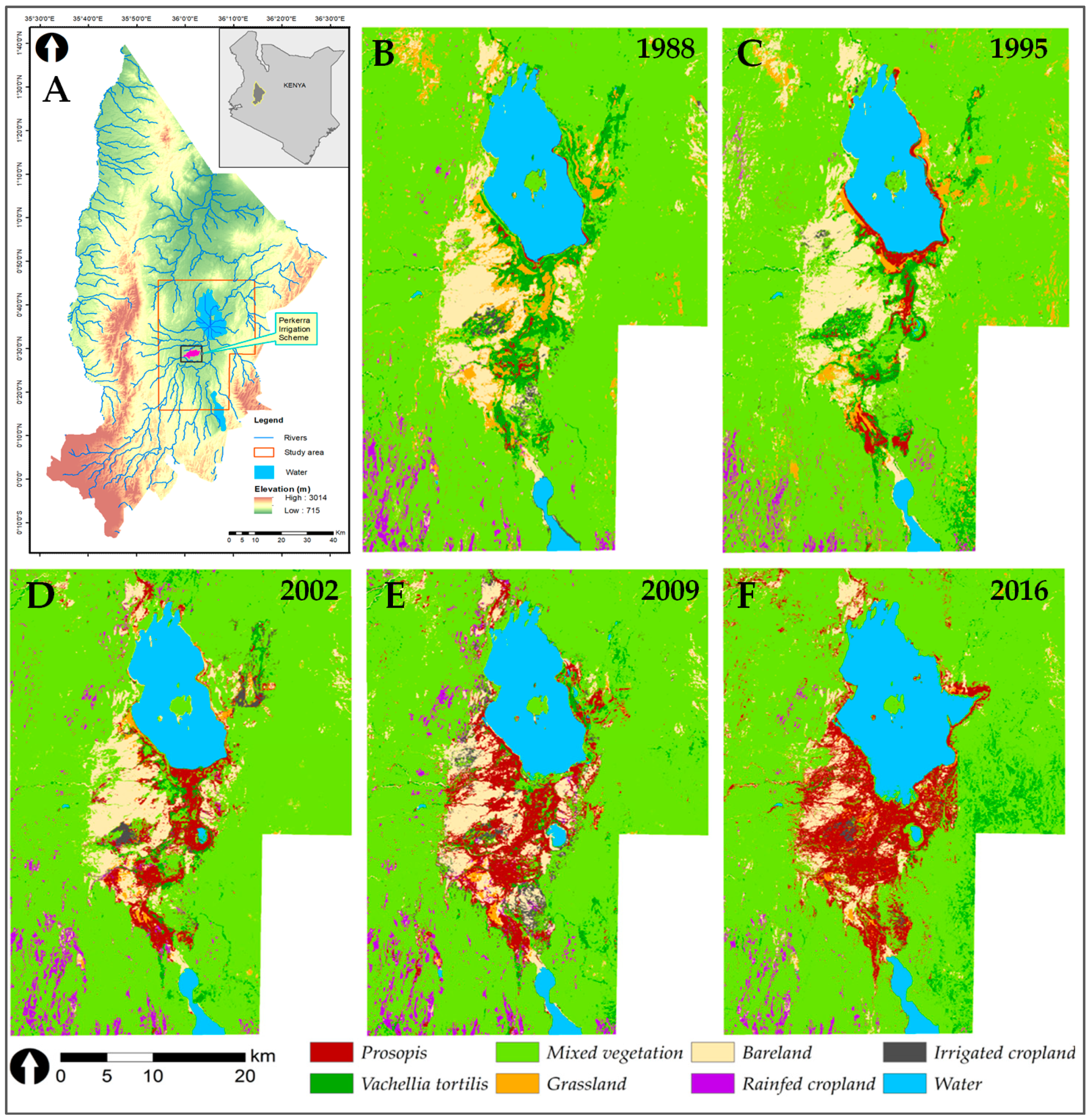
Containing a Woody Weed in Kenya
Prosopis was introduced to Kenya in the 1980s to provide fuelwood; it has since turned into an environmental scourge. Landsat has tracked its fast-paced spread.
Landsat Can Save Federal Agencies up to $7.7 Million Annually in Post-Fire Costs
Using satellite imagery is a cost-effective way to assess burned areas and triage mitigation measures post-wildfire, study found. Federal agencies can save as much as $7.7 million annually in post-fire costs by using Landsat.
Landsat Aids Discovery of Rare Lava Lake on Remote Sub-Antarctic Island
Landsat, Sentinel-2, and ASTER confirm a rare lava lake in Mt. Michael’s crater on the sub-Antarctic Saunders Island—a “remarkable geological feature.”
More than Naught: The “Z” of Where Land Meets Sea
Harnessing 30 years of Landsat data, a team of researchers from Australia has created the first 3D model of Australia’s entire coastline.
NASA Helps Warn of Harmful Algal Blooms in Lakes, Reservoirs
With limited resources to dedicate to monitoring for harmful algal blooms, water managers are looking to new technologies from NASA and its partners to detect and monitor potential hazards in lakes and reservoirs.
Advisory Panel Recommends Landsat Data Stay Free
Keeping Landsat data free and open is the right path forward, a federal advisory panel has concluded.
Introducing Landsat Ice Stream
Seven ice features in western Antarctica have been named for Earth-observation satellites, including one named for Landsat.
RIT Scientists Recognized for Solving Issue with Landsat 8 TIRS Instrument
Aaron Gerace and Matthew Montanaro earned the 2019 USGIF Academic Achievement Award for their work on the Landsat 8 TIRS stray-light issue.
Landsat Science Team Member Feng Gao Wins 2018 Arthur S. Flemming Award
Dr. Gao has been awarded in recognition of his original research in the application of remote sensing for crop and vegetation monitoring.
Containing a Woody Weed in Kenya
Prosopis was introduced to Kenya in the 1980s to provide fuelwood; it has since turned into an environmental scourge. Landsat has tracked its fast-paced spread.
