
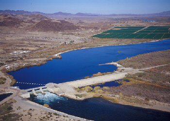
Farm Crops for City Drops: Assessing Water Right Transfers With Landsat
Thirty-one years of observed water use trends in the Southwestern U.S.
Shedding Light on Watershed Management Priorities
Learn more about a water quality modeling tool known as SPARROW.
Landsat 9 Passes Key Decision Point C, Moves on to Implementation Phase
Landsat 9 has entered its implementation phase.
Landsat 9 Ground Network Element Reaches Successful Milestone
The Landsat 9 Ground Network Element’s Preliminary Design Review took place on November 30, 2017.
USGS-NASA Pecora Award Recognizes Excellence in Earth Observation
Two awardees have been presented with the 2017 William T. Pecora Award for achievements in Earth remote sensing.
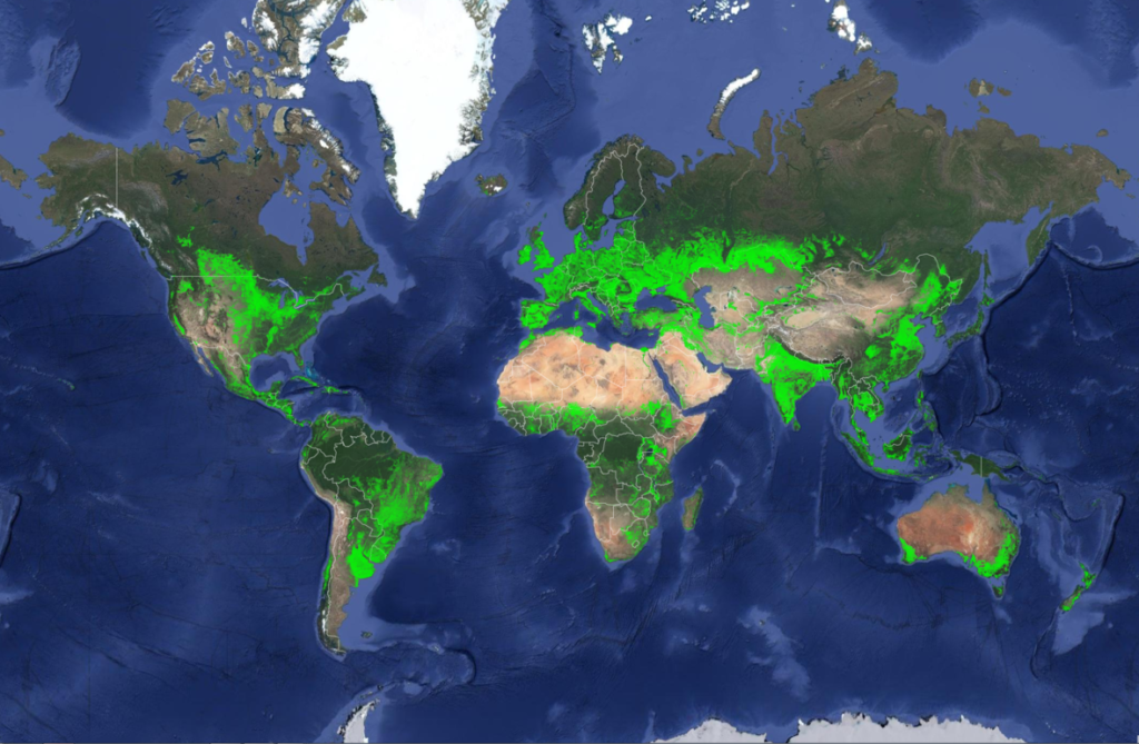
New Landsat-Based Map of Worldwide Croplands Supports Food and Water Security
A new map was released today detailing croplands worldwide in the highest resolution yet.

Uncharted Exhibit in Sioux Falls
Uncharted, a cartographic art installation, was on display for the 2017 Pecora 20 in Sioux Falls, South Dakota.
Wind, Warm Water Revved Up Melting Antarctic Glaciers
A NASA study has located the Antarctic glaciers that accelerated the fastest between 2008 and 2014 and finds that the most likely cause of their speedup is an observed influx of warm water into the bay where they’re located.
Landsat 9 Preliminary Design Review Successfully Completed
The mission team demonstrated to an independent Standing Review Board that all design plans for the Landsat 9 mission are both sound and well integrated.
Hurricane Irma Turns Caribbean Islands Brown
Irma battered several Caribbean islands in September 2017; when the clouds cleared the destruction became obvious even from space.
Upcoming Landsat 9 Preliminary Design Review
The Landsat 9 Preliminary Design Review (PDR) is scheduled for September 12-14, 2017.
Latest Harmonized Landsat Sentinel-2 (HLS) Version Released
When Landsat 8 and Sentinel-2 data are used together observations can be more timely and accurate.
Finding Baltimore's Mosquito Hotspots with Help from Landsat
High levels of residential abandonment and unchecked vegetation growth in low-income neighborhoods are strong indicators of mosquito prevalence. Higher income neighborhoods are also susceptible to mosquito-borne disease due to the presence of irrigated vegetation, which creates mosquito-friendly habitat.
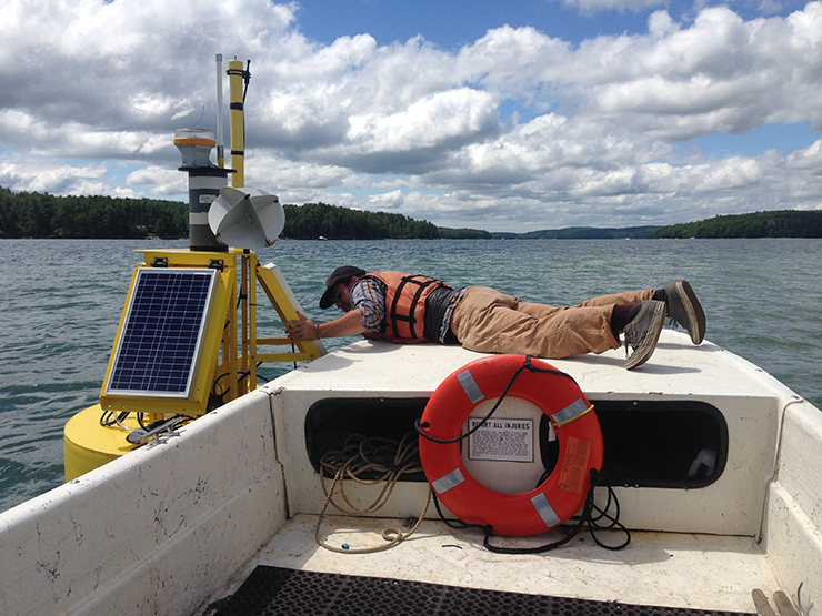
Oyster Prospecting with Landsat 8
In the first study of its kind, researchers from the University of Maine have demonstrated that Landsat 8 satellite data can be used to find locations where oysters farms should thrive.
On Iceberg Watch with Landsat's Night-Vision
NASA Goddard research scientist Chris Shuman spoke recently to National Geographic about Delaware-sized iceberg that broke away from the Larsen C ice shelf last month.
Coming This Fall: Publication of Landsat Legacy Book
A seminal work on the nearly half-century of monitoring Earth’s lands with Landsat will be published this year.
Wind, Warm Water Revved Up Melting Antarctic Glaciers
A NASA study has located the Antarctic glaciers that accelerated the fastest between 2008 and 2014 and finds that the most likely cause of their speedup is an observed influx of warm water into the bay where they’re located.
Landsat 9 Preliminary Design Review Successfully Completed
The mission team demonstrated to an independent Standing Review Board that all design plans for the Landsat 9 mission are both sound and well integrated.
Hurricane Irma Turns Caribbean Islands Brown
Irma battered several Caribbean islands in September 2017; when the clouds cleared the destruction became obvious even from space.
Upcoming Landsat 9 Preliminary Design Review
The Landsat 9 Preliminary Design Review (PDR) is scheduled for September 12-14, 2017.
Latest Harmonized Landsat Sentinel-2 (HLS) Version Released
When Landsat 8 and Sentinel-2 data are used together observations can be more timely and accurate.
Finding Baltimore's Mosquito Hotspots with Help from Landsat
High levels of residential abandonment and unchecked vegetation growth in low-income neighborhoods are strong indicators of mosquito prevalence. Higher income neighborhoods are also susceptible to mosquito-borne disease due to the presence of irrigated vegetation, which creates mosquito-friendly habitat.
Oyster Prospecting with Landsat 8
In the first study of its kind, researchers from the University of Maine have demonstrated that Landsat 8 satellite data can be used to find locations where oysters farms should thrive.
On Iceberg Watch with Landsat's Night-Vision
NASA Goddard research scientist Chris Shuman spoke recently to National Geographic about Delaware-sized iceberg that broke away from the Larsen C ice shelf last month.
Coming This Fall: Publication of Landsat Legacy Book
A seminal work on the nearly half-century of monitoring Earth’s lands with Landsat will be published this year.
