News Archives
7 Million Landsat Scenes and Counting!
The Landsat archive has now surpassed 7 million scenes since Landsat 1 first began collecting data in July 1972.
Celebrating Forty-Five Years of Landsat Acquisitions
It was the first Earth-observing satellite to be launched with the specific intent to study and monitor our planet’s landmasses.
Landsat Helps Map Fires in Western and Southern Cape Provinces of South Africa
Landsat 8 data was used to map the fire extent, measuring some 16,000 hectares of destruction.
Landsat 9 Mission Operations Contract Awarded
General Dynamics Mission Systems (GDMS) of Scottsdale, Arizona has been selected as the contractor responsible for Landsat 9 Mission Operations.
Blazing Fast Relief: A NASA-Supported Tool is Accelerating Wildfire Recovery
Burned Area Emergency Response teams—one of most important parts of wildfires that you’ve probably never heard of.
Requesting Input on Future Landsat Requirements
The U.S. Geological Survey (USGS) is requesting information from the land imaging community for user requirements for future Landsat systems.
![Penguins](https://landsat.gsfc.nasa.gov/wp-content/uploads/2017/06/nu_0212_big.png)
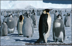
At the Bottom of the World, Satellites Are Guiding Commerce and Conservation
MAPPPD is the first free, open-access Antarctic decision support system that integrates remotely sensed inputs, such as Landsat 7 images and MODIS sea ice data, to provide an assessment of Adélie and other penguin species across the frozen continent.
Mapping Chesapeake's Future From Today's Land Use
USGS’ pixel-by-pixel land use forecasts offer essential road maps for restoration.
News Archives
Spectral Characterization
The measured wavelength locations of the ETM+ spectral bands are compared to Landat 5’s TM in Table 8.1 The spectral bandwidths are determined by the combined response of all optical
Pecora 20 Conference Announcement
The Pecora 20 Conference will be held November 14-16, 2017 in Sioux Falls, South Dakota.
Sentinel-2B Successfully Launches
“This launch completes the Sentinel-2 constellation, providing a tremendous new resource for land management and science.”
Landsat Images Provided to the Disaster Charter, Feb. 2017
This month, 37 Landsat scenes were ingested by the USGS Hazard Data Distribution System to provide data for Charter activations.
Landsat 9 Thermal Instrument Passes Critical Design Review
The Landsat 9 Thermal Infrared Sensor 2 team at the NASA Goddard Space Flight Center has successfully completed their Instrument Critical Design Review.
Landsat 9 Spacecraft Systems Review
USGS and NASA officials will participate in the Landsat 9 Spacecraft System Requirements Review February 28 and March 1 at the Northrop Grumman facility in Gilbert, Arizona.
Successful Maneuver Spells Beginning of the End for Landsat 7
Landsat 7’s Flight Operations Team has performed the last ∆I maneuver for Landsat 7.
Descartes Labs Releases 3.1 Trillion Pixel Landsat 8 Mosaic
Descartes Labs released a 3.1-trillion pixel, cloud-free Landsat 8 composite image of the world along with two others based on the European Union’s Sentinel satellites on Feb. 6, 2017.
Remembering Landsat Leader Phil Sabelhaus
Sabelhaus was pivotal to the development of the most recent Landsat satellites.