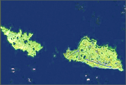
Flocks of formerly endangered Aleutian Cackling Geese enjoy the summertime in the Near Islands at the far western end of Alaska’s Aleutian Islands, which is also home to Eareckson Air Station. The air station is located on Shemya Island, the only island in the group where introduced Arctic Foxes have been allowed to remain. The foxes ensure that the geese are not present on Shemya during the nesting and molting seasons of mid-summer. However, flocks of geese arrive in the spring as grasses grow early in the season abundant with nutrients. As they prepare to migrate south in the fall, the geese move to shrubby areas loaded with berries and to vegetation that greened up late in the summer, where they can eat well before their journey. The increasing goose population in recent years has elevated the risk for bird strikes at Eareckson Air Station. The Bird Aircraft Strike Hazard (BASH) prevention program was implemented by the Department of Defense to provide the safest flying conditions possible.
While you cannot see the birds from space, Matthew Macander and Christopher Swingley of ABR, Inc. Environmental Research & Services mapped the presence or absence of snow and spatio-temporal dynamics of the grassy and shrubby habitats in the Near Islands with Landsat satellite images. Based on the resulting maps, an ABR team including Matt, Gerald Frost, Mark Winterstein, and Patricia Miller visited the islands in spring 2008 and fall 2009 and conducted a habitat-use analysis by counting current-season scat.
Back in the office, they mapped where the geese spent time in the spring and fall, and compared the scat counts with the Landsat images. They determined that there was a key 10-day period needed for BASH mitigation in spring. After their arrival, the geese rapidly moved on as snowmelt proceeded on other islands in the Aleutian Chain. The ABR team additionally recommended mitigation strategies that include habitat modification such as vegetation removal or the types of seeds to avoid when re-vegetation is necessary due to disturbance.
The mapping of habitat with Landsat is hardly a unique application of the data; however, the information gained from the mapping of preferred geese habitat in this very remote region, as well as field surveys, enables new and valuable applied information on BASH mitigation. This knowledge can reduce costs of aircraft repair from multiple strikes and could save the lives of military personnel.
Source: USGS Landsat Stories
Original article:
+ Landsat Stories: Analyzing Landsat to Mitigate Bird/Aircraft collisions

Landsat & LCLUC: Science Meeting Highlights
Outreach specialists from the Landsat Communications and Public Engagement team participated in community engagement efforts at the joint NASA and University of Maryland Land Cover Land Use Change (LCLUC) meeting.


