
On Dec. 17, 2013, the Department of Global Ecology launched the Carnegie Landsat Analysis System-lite (or CLASlite) Classroom hosted by Stanford University Online Learning. It will allow non-commercial users to learn how to use the revolutionary CLASlite software for detecting deforestation and other forest disturbances. It is the culmination of years of work on the part of Asner and his team to make forest-monitoring tools accessible to conservationists, forest managers, decision-makers and forest enthusiasts around the world.
“CLASlite will empower thousands of new forest guardians. A brilliant achievement,” said Bruce Babbitt, former-Secretary of the Interior.
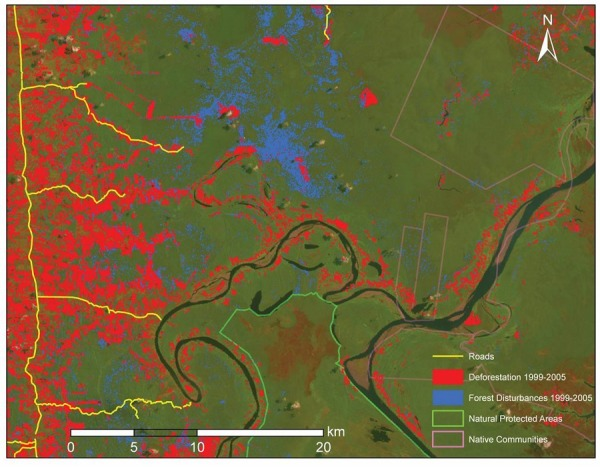
The CLASlite software is a highly automated system for converting satellite imagery from its original, raw format into maps that can be used to find deforestation, logging, and other environmental disruptions. It was developed to help governments, nongovernmental organizations, and academic institutions conduct high-resolution mapping and monitoring of forests as an everyday activity using satellite imagery.
)
“CLASlite represents for our country an improvement in the capacity of over 400 professionals who were trained in the software between 2010 and 2013,” said Peruvian Minister of Environment Manuel Pulgar-Vidal. “With it, we are generating information about the state of the forest that supports the development of public policy for conservation and sustainable use of our Amazonia.”
The idea for the CLASlite Classroom emerged when demand for the software began to exceed the capacity for Carnegie’s scientists to host in-person training workshops. They have trained hundreds of organizations throughout Latin America and elsewhere, but future training will be done via the World Wide Web. The online course teaches people how to use real satellite imagery for forest monitoring with CLASlite. The training includes discussion on how to prepare the imagery and to accurately assess results, plus it gives real-world case studies provided by guest presenters.
“This free, web-based course on CLASlite is the latest innovation in Carnegie’s path-breaking approach to empowering tropical nations, organizations and individuals to achieve excellence in their analysis and monitoring of forests,” said Daniel Nepstad, founder of the Earth Innovations Institute.
The power of CLASlite rests in its unique ability to convert the densely green carpets of tropical forest cover found in the basic satellite images into highly detailed maps that can be readily searched for problem areas. CLASlite differs from other satellite mapping methods in that it uses algorithms to detect changes to the forest in areas as small as 0.1 hectare (0.25 acre), allowing scientists to find small-scale disturbances that cannot be detected by traditional satellite methods. Places where clearing, logging and other forest disturbances have recently occurred are accentuated and easily identified by CLASlite’s algorithms.
CLASlite has recently been used to demonstrate the true extent of gold mining in Peru’s Amazon, where thousands of small, clandestine mines have boomed, contributing to a tripling of the annual rate of forest loss over the past decade. CLASlite Classroom will allow more organizations and individuals to tackle crucial conservation crises such as this one.
“Forested countries like Indonesia need timely and accurate information on their forests in order to manage and protect them. CLASlite can help Indonesia strengthen its capacity to monitor and address deforestation,” said Agus Purnomo, Climate Change Advisor to the President of Indonesia.
Carnegie will be the first organization on the planet to provide a complete, packaged course and advanced deforestation mapping software to people online and free-of-charge. The impact this will have on conservation and management efforts could be tremendous.
“When I was in graduate school in the 90s, a single satellite image could cost more than $2,000 and only a few elite groups could afford the data,” Asner said. “Much has changed since then, but a means of empowering people to perform forest monitoring on their own is still missing. Launch of CLASlite Classroom aims to change that. My team and I believe in putting learning first so that forest monitoring will be undertaken with independence and transparency. Our forests depend on it because forest stewardship begins with personalized forest monitoring.”
Added James Irons, NASA’s Landsat project scientist: “CLASlite is a great example of the technical development necessary to fully leverage Earth observations from space, such as those provided by the Landsat program. Open access to such a user-friendly monitoring approach goes hand-in-hand with NASA’s deployment of Landsat satellites to reliably collect high-quality images and USGS’ enlightened policy of free data distribution from its multi-decadal image archive.”
The course (http://claslite.ciw.edu/en/ will initially be offered in English, followed by Spanish. Other languages will be added as needed.
The CLASlite Classroom is made possible by the generous support of the Gordon and Betty Moore Foundation.
Further Information:
+ Forest monitoring: bringing the power to the people
+ Greg Asner: Ecology from the air, TED

Be Part of What’s Next: Emerging Applications of Landsat at AGU24
Anyone making innovative use of Landsat data to meet societal needs today and during coming decades is encouraged to submit and abstract for the upcoming “Emerging Science Applications of Landsat” session at AGU24.


