How to Manage a Satellite Going 17K MPH
Covington tells the story of Landsat 5, which was launched in 1984 for a three-year lifetime and was kept alive for nearly 29 years through ingenuity and luck.

Covington tells the story of Landsat 5, which was launched in 1984 for a three-year lifetime and was kept alive for nearly 29 years through ingenuity and luck.
An incorrect bias adjustment for Thermal Infrared Sensor (TIRS) data was discovered in the latest release of the Landsat 8 processing system, which has caused a significant error in the TIRS products produced from Landsat 8 scenes acquired from January 14, 2014 to January 23, 2014.
In Geneva on January 17, 2014, the Group on Earth Observations (GEO) received unanimous endorsement to unleash the power of open data for a second decade. There was agreement to continue building on the organization’s first 10 years of pioneering environmental advances, which are designed to improve the quality of life of people everywhere. Fueled by open data, GEO’s efforts are now evident in most regions of the world. GEO is comprised of 90 member nations, including the European Commission and 77 Participating Organizations.
In December 2013, the Secretariat Director of the Group on Earth Observations gave a TEDx talk in Barcelona, Spain making the case that all Earth-oberservation data collected from governments and institutions should be open and available to everyone. She illustrates how this could reduce hunger and improve the quality of life of all Earth’s inhabitants. Ryan emphasizes that Earth observation data show Earth without political boundaries, as an entire system.
New Ground Control Points (GCPs) will become available for three WRS-2 path/rows and GCPs contained within large water bodies will be removed on February 3, 2014 to coincide with the Landsat 8 archive reprocessing. As a consequence of the improved GCPs, scenes once created as a systematic Level 1GT (L1GT) product may now process to a precision Level 1T (L1T) product.
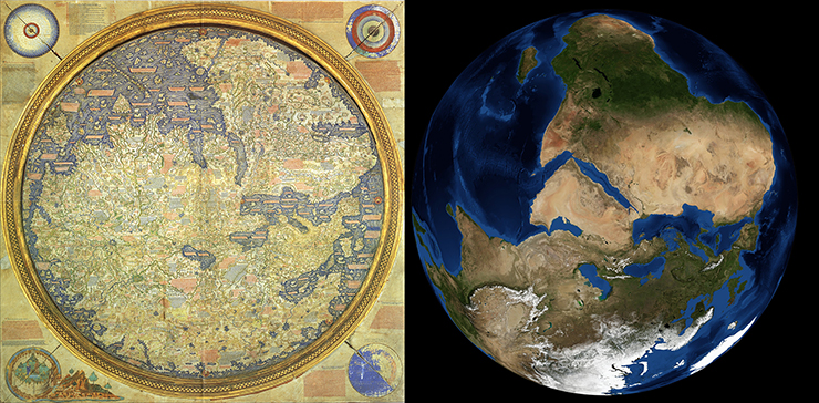
Long before the famous Earthrise photo taken by Apollo astronauts, creating an image or map of the entire known world was a singular human endeavor. Imagine a half a millennium earlier when only those who had traveled could describe distant lands. Imagine watching the hustle and bustle of merchants and sailors returning to the port of Venice. What stories could they tell to paint a portrait of our planet?
Landsat data processing will be stopped beginning at 3 p.m. CT on January 17, 2014, until 12 p.m. CT January 21, 2014 for server upgrades. Any on-demand orders placed will be held and the data will be processed when the upgrades are complete.
The Landsat Science Team met in Washington D.C. for a meeting on the future of the Landsat program.
Today, Chris Herwig from MapBox presented at the Federation of Earth Science Information Partners (ESIP) about MapBox’s endeavor to use both MODIS and Landsat data to create a cloud-free world atlas.
As part of the International Charter—Space and Major Disasters, a number of satellite-derived maps showing the extent of flooding across the UK have been released, including the above Landsat 8-derived map of flooding along the River Thames near Oxford.
Beginning February 3, 2014, all Landsat 8 data held in the USGS archives will be reprocessed. All Landsat 8 scenes will be removed from the online cache at this time and the data will then be reprocessed starting with the most recent acquisitions and proceeding back to the beginning of the mission. Data will then become available for download. Scenes waiting to be reprocessed will also be available for on-demand product orders. Reprocessing is expected to take approximately 50 days.
