Sharp Bends Make Rivers Meander, As Landsat Attests
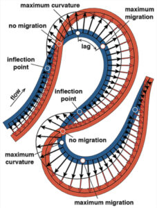
Turns out, the rate of river migration is directly linked to how sharp its bends are.

Turns out, the rate of river migration is directly linked to how sharp its bends are.
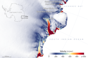
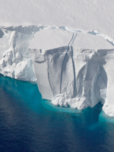
New detailed NASA maps of ice velocity and elevation show that a group of glaciers spanning one-eighth of East Antarctica’s coast have begun to lose ice over the past decade, hinting at widespread changes in the ocean.
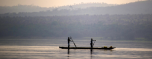
Increasingly, water managers are turning to satellites like Landsat to monitor inland waters.
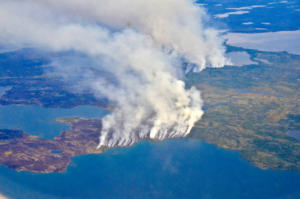
The 2014 megafires in Canada’s Northwest Territories burned 7 million acres of forest, making it one of the most severe fire events in Canadian history.
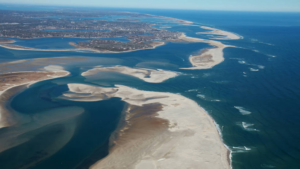
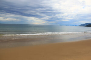
Using 30 years of Landsat data, a team of scientists and engineers from the Netherlands determined how Earth’s sandy beaches are changing.
This is the first study to document more than three decades of land and water changes across Alaska.
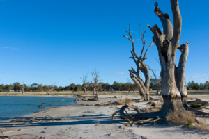
Using a quarter century of Landsat data, geospatial researchers have mapped and modeled how vegetation responds to water availability across the entire Murray-Darling Basin.
National Park Service cartographer Tom Patterson’s mapmaking process often incorporates information from Landsat.

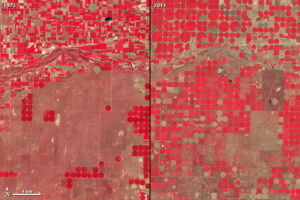
Researchers armed with data from the Landsat Earth-observing satellites recently teamed up with Google to track water used for irrigation.
In the first study of its kind, researchers from the University of Maine have demonstrated that Landsat 8 satellite data can be used to find locations where oysters farms should thrive.
Using 28 years of Landsat data, an Australian research team has created a continent-wide intertidal zone extent map for the whole of the Australian coast.
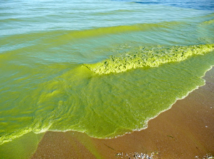
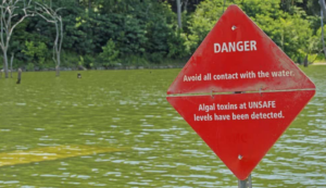
With the growing frequency and magnitude of toxic freshwater algal blooms becoming an increasingly worrisome public health concern, Carnegie scientists Jeff Ho and Anna Michalak, along with colleagues, have made new advances in understanding the drivers behind Lake Erie blooms and their implications for lake restoration.
Approximately 345,000 or fewer chimpanzees remain in the wild, according to the International Union for the Conservation of Nature, a substantial decline from the more than two million that existed a hundred years ago.
Scientists are providing a near-real-time view of every large glacier and ice sheet on Earth with Landsat 8.
Over 375 presentations at this year’s AGU Fall feature Landsat.
Today, we are getting richer and more plentiful information about Earth’s land surface than ever before. But amid all of this modern Earth observing splendor, one truism remains: No sensor can image the past.
Forests are commodities. The biggest driver of deforestation worldwide is the economic value of trees and the land they stand on. With the high demand for agricultural land and wood products, deforestation has become an intractable problem.
Nearshore shipwrecks can leave telltale sediment plumes at the sea’s surface that reveal their location. Using Landsat 8 data, researchers have detected plumes extending as far as 4 kilometers (~2.5 miles) downstream from shallow shipwreck sites. This discovery demonstrates that Landsat and Landsat-like satellites can be used to locate the watery graves of coastal shipwrecks.
NASA has awarded a sole source letter contract to Ball Aerospace & Technologies Corporation, Boulder, Colo., to build the Operational Land Imager-2 instrument for the Landsat 9 project.
At this year’s AGU Fall meeting over 325 presentations feature research done using Landsat data. The Landsat-related papers and posters run the gamut of disciplines from cryosphere to biogeoscience to hydrology to global environmental change to natural hazards to informatics.

On the most recent nautical chart of the Beaufort Sea where the long narrow Tapkaluk Islands of Alaska’s North Slope separate the sea from the shallow Elson Lagoon (Nautical Chart 16081) a massive shoal is immediately noticeable just west of the entrance to the lagoon. On the chart it looks like a massive blue thumb jutting out into the sea. The National Oceanographic and Atmospheric Administration (NOAA) identified this prodigious, 6-nautical mile-long, 2-nm-wide shoal using Landsat satellite data.
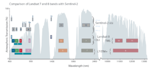
The European Space Agency’s Sentinel-2A successfully launched into orbit last night from Europe’s Spaceport in Kourou, French Guiana aboard a Vega rocket (10:52 p.m. local time; 01:52 GMT).
![The sensors aboard Landsat 8 were designed to have higher sensitivity to brightness and color; they use 4,096 values to digitize their signals (12-bit data) whereas the last-generation sensor on Landsat 7 was slightly less sensitive and used only 256 data values (8-bits) to describe the range of brightness it recorded. Visually, this translates into a smoother, less noisy looking images as can been seen here when comparing these natural color Landsat 7 [left] and Landsat 8 [right] images of the extensive coral reefs on the northern shore of Vanua Levu, Fiji’s second largest island, acquired on September 19, 2002 and May 10, 2015, respectively.](https://landsat.gsfc.nasa.gov/wp-content/uploads/2015/06/Levu_Fiji_L8_sm-1-300x127.jpg)
With Earth-observing satellite data, scientists can now monitor the health of coral reefs, even in the most remote regions scattered around the globe where it is otherwise difficult to see changes.

Last Thursday, Amazon Web Services (AWS) announced that it is now hosting Landsat 8 imagery on its publicly accessible Simple Storage Service (S3).
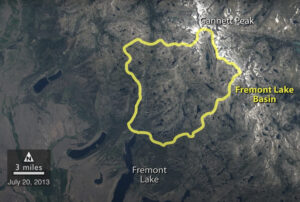
A NASA study of a basin in northwestern Wyoming revealed that the snowmelt season in the area is now ending on average about sixteen days earlier than it did from the 1970s through the 1990s.

The rate at which tropical forests were cut, burned or otherwise lost from the 1990s through the 2000s accelerated by 62 percent, according to a new study which dramatically reverses a previous estimate of a 25 percent slowdown over the same period. That previous estimate, from the U.N.’s Food and Agriculture Organization’s (FAO) Forest Resource Assessment, was based on a collection of reports from dozens of countries. The new estimate, in contrast, is based on vast amounts of Landsat image data which directly record the changes to forests over 20 years.
Orbiting Earth more than 400 miles away in space, far from human view; recording repeated images of land around the globe for more than 42 years; offering customers petabytes of historical and current data for free, the Landsat program of Earth observing satellites could be seen as the personification of the most single-minded office worker — tirelessly systematic, yes, but after so many years, perhaps less than dramatic.
