Presentation Title
Monitoring Phenology of Coastal Marshes in Louisiana using the Landsat Archive
What are the major findings of this research?
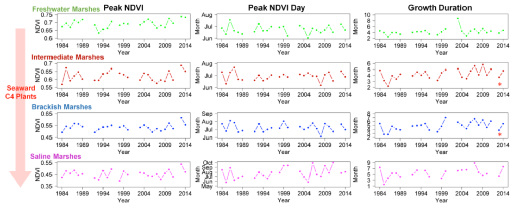
The environmental records prove that coastal marshes in Louisiana are experiencing climate change in terms of increasing temperature, sea level, and atmospheric CO2. The phenological records show that the growth durations of intermediate and brackish marshes extended as atmospheric CO2 level increased over the last 30 years.
What are the implications of your findings?
The prolonged growth durations of intermediate and brackish marshes indicate a potential increase in carbon sequestration of the marshes over the last 30 years, suggesting a possible negative feedback to climate change. But this hypothesis needs to be further examined with more information such as the marshland area changes over the same period of time.
What insight did you gain from Landsat that would have been impossible to glean otherwise?
The 30-year record of the Landsat sensors (i.e. TM, ETM+, and OLI) provides a unique data archive for studying the impacts of climate change on ecosystems worldwide, in our case, coastal marshes. The 30 m spatial resolution of the data allows our results to better represent the highly heterogeneous environment of the coastal marshes.
Why is the C4 photosynthesis pathway less responsive to elevated CO2 than the C3 pathways?
The C3 photosynthesis pathway uses the enzyme RuBisCO to fix atmospheric CO2. But RuBisCO also binds oxygen in the process of photorespiration, which reduces the efficiency of photosynthesis. The elevated atmospheric CO2 level would increase CO2/O2 ratio in the atmosphere, which promotes photosynthesis and suppresses photorespiration and thus increase the C3 photosynthesis efficiency. The C4 photosynthesis pathway uses PEP carboxylase to fix atmospheric CO2. PEP doesn’t binds with oxygen, thus the C4 pathway is less influenced by the CO2/O2 ratio in the atmosphere. Therefore, the C4 photosynthesis pathway is expected to be less responsive to elevated atmospheric CO2 level.

Co-authors:
Michael Kearney
University Maryland
J. C. Alexis Riter
University of Maryland
This research was made possible by a grant from The Gulf of Mexico Research Initiative. Data are publicly available through the Gulf of Mexico Research Initiative Information & Data Cooperative (GRIIDC).
Anyone can freely download Landsat data from the USGS EarthExplorer or LandsatLook.
Further Reading:
+ Landsat Abounds at #AGU16

Be Part of What’s Next: Emerging Applications of Landsat at AGU24
Anyone making innovative use of Landsat data to meet societal needs today and during coming decades is encouraged to submit and abstract for the upcoming “Emerging Science Applications of Landsat” session at AGU24.


