Dr. Joshua Fisher is the ECOSTRESS Mission Science Lead at NASA’s Jet Propulsion Lab. Here is what Josh shared with us about the work he is presenting today at #AGU19:
NASA evapotranspiration data significantly improve water management for the State of New Mexico
What are some ways in which NASA ET are improving water management in New Mexico?
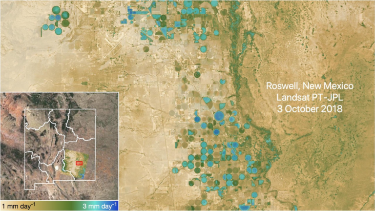
My project, funded by NASA’s Western Water Applications Office (WWAO), entails infusing NASA ET data with decision-making of the New Mexico Office of the State Engineer and partners. New Mexico is one of the most arid states in the US, and precise and accurate information on water use is of utmost importance. Generally, the decision-making contexts fall into 3 categories: I) agriculture and water rights; II) forest maintenance; and, III) river management. One example is in the realm of water rights transfers—water rights holders must have historically used their water for beneficial use in order to retain their right. But, this is often difficult to demonstrate. However, it is very easy for this use to be seen from remote sensing, particularly in the multi-decadal record of Landsat.
What makes ECOSTRESS, NASA/USGS Landsat, and MODIS data useful for mapping evapotranspiration?
ECOSTRESS, Landsat, and MODIS are all very useful for mapping different components of evapotranspiration through the use of thermal infrared remote sensing in conjunction with visible-near infrared measurements and meteorological inputs. Landsat has an incredible multi-decadal record at fine spatial resolutions. This is particularly useful for the example in question 1. MODIS provides excellent temporal resolution for daily estimates, and we know that ET can change a lot from day to day. Finally, ECOSTRESS combines strengths of both Landsat and MODIS by providing high spatial resolution and good temporal resolution data. Moreover, ECOSTRESS samples the diurnal cycle, which is providing key insight into diurnal variability linked to water stress.
What role does Landsat have to play alongside ECOSTRESS?
The combination of Landsat and ECOSTRESS is very powerful. The measurements are highly synergistic for ET. ECOSTRESS also uses Landsat (and Sentinel 2AB too) for the VNIR measurement needed for ET. Given that Landsat repeat is 16 days, and ECOSTRESS repeat is variable between 1-5 days, the combination of Landsat and ECOSTRESS gets us closer to the daily repeat at high spatial resolution.
Co-authors:
Gregory Halverson
NASA Jet Propulsion Laboratory
Malvika Khanna
Jet Propulsion Laboratory, California Institute of Technology
Jerri Pohl
New Mexico Office of the State Engineer
Matthew Nelson
New Mexico Office of the State Engineer
Molly Magnuson
New Mexico Office of the State Engineer
Frank Scott
New Mexico Office of the State Engineer
This work is funded by the NASA Western Water Applications Office (WWAO).
Further Reading:
+ Landsat at the 2019 AGU Fall Meeting
Anyone can freely download Landsat data from the USGS EarthExplorer or the LandsatLook Viewer.