Landsat Reveals Vanishing River Ice

Landsat Reveals Vanishing River Ice

mean river ice extent map
Map showing mean river ice extent in northern hemisphere winter (Dec.–Feb.) and southern hemisphere winter (June–Aug.). Most ice-covered rivers are found in the Northern Hemisphere. Image credit: Joshua Stevens, NASA Earth Observatory, using data from Yang, X., et al. (2020)

melt water
A natural-color NASA/USGS Landsat 8 image showing ice breaking up in the Lena River Delta on June 11, 2015. Some of the ponds appear green because they have a layer of melt water over a lower layer of ice. Image credit: Joshua Stevens, NASA Earth Observatory / NASA/USGS Landsat 8

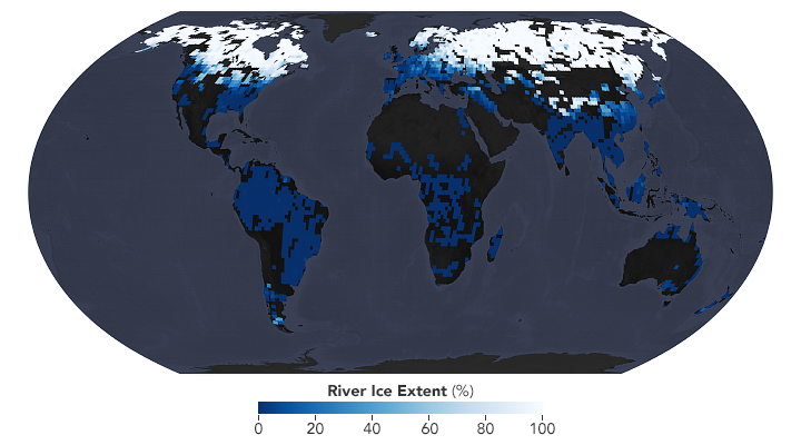
A first-of-its-kind study has used 400,000 NASA/USGS Landsat images collected between 1984 and 2018 to understand global river ice trends. According to the study, published in Nature on Jan. 1, 2020, the extent of wintertime river ice has declined globally over the past three decades, with rivers of the Tibetan Plateau, Alaska, and eastern Europe showing the biggest declines.

Led by researchers at the University of North Carolina–Chapel Hill and Texas A&M University, the study projects six days less of river ice cover for every 1ª C rise in global temperature. Rivers of the Rocky Mountains and northeastern U.S. will experience heavy future ice cover declines (along with rivers of eastern Europe and the Tibetan Plateau).

Yukon River
A NASA/USGS Landsat 8 image from April 30, 2019 showing ice cover on the Yukon River approaching its confluence with the Tanana River in Alaska.

More than half of Earth’s rivers are covered with ice seasonally, these rivers drain a third of the planet’s landmass. The later freeze-ups and earlier thaws that global rivers are experiencing, come with ecologic and economic impacts.

For more information, see:

+ River Ice Is Disappearing, Eos

+ Rivers Are Getting Less Icy, NASA Earth Observatory

+ New study estimates the global extent of river ice loss as Earth warms, UNC–Chapel Hill University Communications

Reference:

Yang, Xiao, Tamlin M. Pavelsky, and George H. Allen. 2020. “The past and future of global river ice.” Nature 577 (7788):69-73. doi: 10.1038/s41586-019-1848-1.

Get the latest from Landsat in your inbox.


By submitting this form, you are consenting to receive marketing emails from: Landsat Science. You can revoke your consent to receive emails at any time by using the SafeUnsubscribe® link, found at the bottom of every email. Emails are serviced by Constant Contact
On Key

Recent Posts

Map shows South Korea with waterways highlighted. In the top right corner is a north arrow and in the bottom left corner is a legend of different rivers in South Korea.

Monitoring Water Quality in South Korea

South Korea is facing a water quality problem. Researchers Hyunglok Kim and Seongjun Lee from the Gwangju Institute of Science and Technology (GIST) embarked on developing a model to predict water quality indicators in near real-time.

Read More »
Landsat outreach specialist Allison Nussbaum and GEDI/UMD Faculty Specialist Talia Schwelling hold Landsat/GEDI postcards at the NASA exhibit booth at AGU24.

Landsat at AGU24

The NASA Landsat Science and Outreach teams attended the American Geophysical Union’s annual meeting in DC in December. At AGU24, they shared research and educated the public about Landsat.

Read More »
On Key

Related Posts

Map shows South Korea with waterways highlighted. In the top right corner is a north arrow and in the bottom left corner is a legend of different rivers in South Korea.

Monitoring Water Quality in South Korea

South Korea is facing a water quality problem. Researchers Hyunglok Kim and Seongjun Lee from the Gwangju Institute of Science and Technology (GIST) embarked on developing a model to predict water quality indicators in near real-time.

Read More »