
Presentation Title
The Secret Lives of Migrating Rivers
What are the major findings of this research?
Our research was motivated by a common problem in studies of river migration: a lack of adequate snapshots through time to characterize river dynamics.
In light of this, we embarked on this project with two broad research questions: 1) can Landsat imagery accurately resolve river dynamics at annual timescales over large spatial domains? and 2) what insights do high-temporal frequency snapshots provide that would otherwise be unavailable?
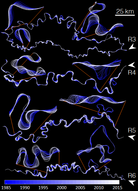
Our test-case of the Ucayali River demonstrated that indeed, mapping river planform dynamics at an unprecedented spatial scale and annual frequency is possible by mining the Landsat archives, paving the way for continental- or global-scale analysis. Combined with only limited field data, our study allowed us to parse simultaneous climate, sediment, and cutoff controls on river migration and width.
We were also able to document the first evidence linking meander cutoffs to nonlocal morphodynamic changes and provide evidence of avalanching dynamics in meandering rivers.
What are the implications of your findings?
Our findings cast new light on the processes controlling river migration and suggest that current models of long-time meander migration may not include key mechanisms.
Our dataset presents a challenge to the modeling community, but also provides hints toward formulating more realistic models. High-temporal frequency observations of the Ucayali River responding to cutoff perturbations also provides insights into how river systems are “authors of their own geometry.”
What insight did you gain from Landsat that would have been impossible to glean otherwise?
The Landsat archives were the foundation of our study. Landsat unlocks the previous three decades’ of global river changes by recording these “natural experiments.”
We were able to quantify the degree of accelerated migration and channel widening caused by 13 cutoff events, estimate the amount of sediment released into the channel due to the cutoffs, and infer the physical processes driving river response to cutoffs.
We are excited about the potential of Landsat imagery to show us how rivers respond to a variety of natural and anthropogenic perturbations across the globe, including deforestation, damming, gold mining, climate changes, and tectonic activity.
Did your team develop RivMAP?
Yes, we developed the RivMAP toolbox because we needed tools to efficiently map and measure both river planform statistics and morphodynamics over very large spatial domains. RivMAP relies heavily on powerful image processing techniques for rapid analysis of large datasets. We continue to devlop RivMAP as we expand our analysis to even larger domains and more complex channels.
Co-authors:
Ankush Khandelwal
University of Minnesota Twin Cities
Mulu Fratkin
University of Minnesota Twin Cities
Vipin Kumar
University of Minnesota Twin Cities
Efi Foufoula-Georgiou
University of California Irvine
University of Minnesota Twin Cities
Anyone can freely download Landsat data from the USGS EarthExplorer or LandsatLook.
Further Reading:
+ Landsat Abounds at #AGU16

Be Part of What’s Next: Emerging Applications of Landsat at AGU24
Anyone making innovative use of Landsat data to meet societal needs today and during coming decades is encouraged to submit and abstract for the upcoming “Emerging Science Applications of Landsat” session at AGU24.


