
Dr. Alice Alonso, a former research scientist at NC State’s Biosystems Analytics Lab, submitted the winning image. We spoke with Alonso, who is now at the Université catholique de Louvain in Belgium, about her research and her reason for submitting the winning Landsat 8 image.
Your submission of a Landsat 8 image recently won first place in NC State’s Envisioning Research contest. Can you tell us a bit about this contest?
Each year, NC State calls on graduate students, postdocs, faculty and staff to take part in a research image contest they call Envisioning Research. The goal of the contest is to highlight the beauty and importance of the work being done at the bench and in the field, both on campus and around the world.
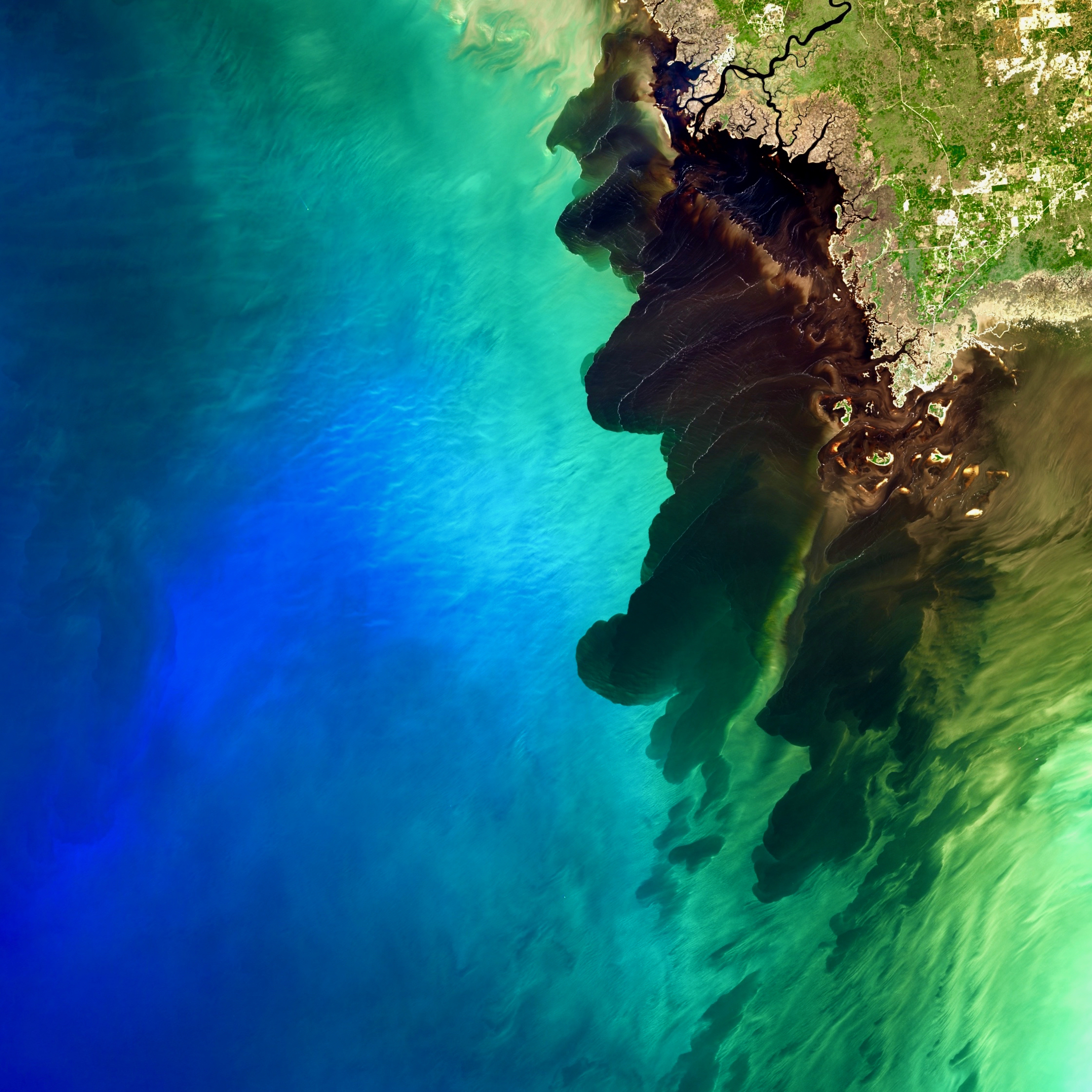
Can you explain what we are seeing in this Landsat 8 image of the Suwannee River Estuary that took first place in the contest?
As the Suwannee River slowly flows through its flat basin and surrounding swamps, the river collects organic matter that degrades into a tannic substance that gives the river a dark color.
The Landsat 8 image submitted for the contest captures a large river discharge event, which resulted in a mesmerizing dark river plume contrasting with the deep blue color of the Gulf of Mexico.
On a more technical note, this image was captured by Landsat 8 on February the 20, 2015 and was created using band 4, band 3 and band 2 displayed as red, green and blue respectively.
Why did you decide to submit this Landsat 8 image?
We gasped in astonishment the first we saw that image and have been fascinated by it ever since.
When presenting preliminary results during our group meeting, Lise Montefiore, a PhD student in Dr. Natalie Nelson’s research group (Biosystems Analytics Lab – Department of Biological and Agricultural Engineering at North Carolina State University) suggested to submit it to a photo contest.
We first thought it was not appropriate since we did not take that picture ourselves, but it marvelled so many peers that we decided it was worthwhile sharing it with a broader audience. We found it was a nice way to communicate about our research, and about the use we are making of satellite images to further the understanding of ecosystem functioning.
We also find that a piece of art is something that, no matter how often you look at it, keeps triggering some sort of emotion. That’s what this is image does to us, so that was one more reason that motivated us to submit it.
Can you tell us more about your research and how Landsat data are used in your research?
One of Dr. Nelson’s lab’s research avenues is the study of how land-use changes and human activities impact estuaries’ health.
In this particular project, we are studying oyster reefs’ effects on salinity regulation in the Suwannee River Estuary. By positioning themselves parallel to shore, previous studies have indicated that oyster reefs essentially act as dams detaining freshwater flowing from the river, hence creating brackish water conditions ideal for the oyster’s development.
These preliminary findings were based on simplified modelling and in situ point-scale measurements. In our study, we are leveraging the spatio-temporal information enclosed in the Landsat images to better characterize and understand these feedbacks relationships between oyster reef growth and freshwater detention at the scale of the estuary.
At a later stage of our study, we hope to be able to use the full-length of the Landsat archive as a window into the past to observe whether these relationships have been altered through time, which might provide insight as to which drivers triggered oyster reef decline in the estuary.
What are the changes in the Suwannee River waters that are threatening the area’s oyster reefs?
Past studies have suggested that changes in nearshore salinities (as a function of reduced freshwater discharge) may have contributed to the loss of oyster reefs, with decreases in Suwannee River discharge occurring due to upstream water withdrawals. However, researchers are actively investigating the underlying cause of oyster reef loss in the region, so this remains an ongoing line of inquiry.
Will information from Landsat help in the quest to protect these reefs?
Landsat provides regional-scale, repeated and long-term observations of the estuarine system. This unique source of information will help elucidate the feedbacks shaping better oyster reef and estuarine water quality. The improved understanding should help practitioners unravel the environmental regulating done by oyster reefs as well as how the reefs themselves are regulated by the environment. This is critical for successfully implementing future restoration programs.
Related reading:
+ Envisioning Research Winners Capture Insights Into the World Around Us, NC State University News
+ Winning Envisioning Science images on the NC State Flickr site
+ Oyster Prospecting with Landsat 8

Be Part of What’s Next: Emerging Applications of Landsat at AGU24
Anyone making innovative use of Landsat data to meet societal needs today and during coming decades is encouraged to submit and abstract for the upcoming “Emerging Science Applications of Landsat” session at AGU24.


