Losing Tidal Flats Around the Yellow Sea
Using Landsat time series data, a group of Australian and British ecologist have found that the Yellow Sea has lost 28% of its tidal flats in the last three decades.

Using Landsat time series data, a group of Australian and British ecologist have found that the Yellow Sea has lost 28% of its tidal flats in the last three decades.
An international team led by glaciologists from the University of Colorado Boulder and Trent University in Ontario, Canada has completed the first mapping of virtually all of the world’s glaciers—including their locations and sizes—allowing for calculations of their volumes and ongoing contributions to global sea rise as the world warms.
California’s persistent drought is forcing grape growers to keep a more-attentive-than-normal eye on their vines, as water shortages and elevated temperatures alter this year’s growing season.
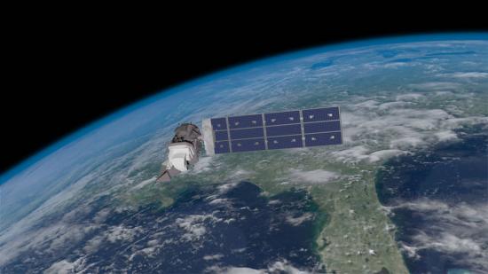
One year ago today, Landsat 8 blasted off from California’s Vandenberg Air Force Base and arched over the shimmering Pacific on its way into orbit. Landsat 8’s main sensor, the Operational Land Imager (OLI), is the latest model in the long line of Landsat Earth-looking radiometers—sensors that have been measuring visible and infrared light reflected from our planet since 1972.
It takes a lot of land to grow food for the world’s seven billion people. About a third of Earth’s terrestrial surface is used for agriculture. And about a third of that, in turn, is used to grow crops. Now, a new NASA-funded effort aims to map crop fields worldwide, identify what’s growing where, and determine whether it’s irrigated or fed by rain.
Speeding around the Earth at 16,800 mph (27,000 kph), two Landsat satellites are quietly, expertly watching and recording changes in Earth’s lands from space. They are gathering data for people to make maps–all kinds of wonderful maps–of our cities growing, rivers flooding, lava flowing from volcanic eruptions, forests expanding or shrinking, crops greening through the growing season, and even of evidence of pollution.
Large underground water reserves have been found in Turkana, one of Kenya’s driest and poorest regions. The discoveries were made by the natural resources exploration firm, Radar Technologies International, during the course of a survey of groundwater conducted for the Kenyan Government on behalf of the UN. The aquifers were detected with the WATEX System, RTI’s state-of-the-art, space-based exploration technology.
WNYC’s Leonard Lopate talks with SkyTruth president, John Amos, about using public domain satellite imagery, such as Landsat, to monitor the environment. SkyTruth uses all types of satellite imagery to monitor environmental changes and disasters; Landsat is prominently mentioned among them.
Images from Landsat satellites provided free to the public by the Department of the Interior’s U.S. Geological Survey were the starting points for “a new
For the first time, U.S. Geological Survey scientists have mapped long-term average evapotranspiration rates across the continental United States—a crucial tool for water managers and
Landsat is a critical and invaluable tool for characterizing the landscape and mapping it over time. Landsat data provides a baseline of observations for science
Does remote-sensing information, such as that from Landsat and similar Earth-observing satellites, provide economic benefits to society, and can this value be estimated? Using satellite data for northeastern Iowa, U.S. Geological Survey scientists modeled the relations among land uses, agricultural production, and dynamic nitrate (NO3–) contamination of aquifers.
Cladophora, a nuisance, native green algae that grows attached to solid substrate in all of the Laurentian Great Lakes, has expanded its range partially due
[Source: Library of Congress] Dr. Martha Anderson, research scientist, USDA, talks about using images from the Landsat satellite program to monitor water use and drought
In the July issue of Nature Climate Change, Tandong Yao and colleagues report on the changing status of Tibetan Plateau glaciers over the past three decades.
Satellite images show big changes happening to Chesapeake Bay, the largest estuary in the U.S., where freshwater meets the sea. Peter Claggett is a research
A water-rich polka dot pattern takes over the traditional rectangular patchwork of fields in this time series animation of 40 years of Landsat images. In
A new study examining nearly 40 years of satellite imagery has revealed that the floating ice shelves of a critical portion of West Antarctica are
Source: Times-News Magic Valley Since 2000, Dr. Rick Allen has been using Landsat to manage water in Idaho. By using Landsat to measure evapotranspiration, water consumption
• Speaking at an important state-wide water summit in March, Nevada Governor Brian Sandoval lauded DRI’s METRIC program calling its Landsat satellite technology an important
• Floods are considered the number one natural hazard, causing more deaths and damage year after year. The National Science Foundation (NSF) provided funding to
The green fields that dot the desert draw on water that in part was trapped during the last Ice Age. In addition to rainwater that
• Water is an essential resource for food cultivation. With 7 billion humans to feed, efficiently managing the planet’s water supply is essential. On March
Every month, the National Oceanic and Atmospheric Administration’s (NOAA) Center for Climate Prediction has a drought briefing by teleconference to identify the latest drought areas
Over dinner on R.V. Calypso while anchored on the lee side of Glover’s Reef in Belize, Jacques Cousteau told Phil Dustan that he suspected humans were having a negative impact on coral reefs.
• On January 16, 2012, Mozambique’s coast was hit by the tropical depression “Dando” followed by cyclone “Funso.” With wind speeds up to 220 km/hour
• UNESCO began mapping groundwater this January in the drought-stricken Horn of Africa, in order to bring the population a sustainable water supply. Drought has
Contributor: Vicky Fakan, USAID USAID has long been a major actor helping to conserve Guinea’s forest reserves, which replenish many of West Africa’s life-sustaining waterways. Now,
Martha Anderson, a research scientist at the U.S. Department of Agriculture, uses images from the Landsat satellite program to monitor water use and drought on
Remnants of Hurricane Irene caused heavy flooding, as shown in thisAugust 31 Landsat 5 image, in the hamlet of Pine Island in the town of
A recent publication inGeophysical Research Letters has called into question the effectiveness of current wetland restoration methods. Using more than two decades worth of Landsat data,
Eastern Africa is in the grip of the worst drought it has seen in 60 years and the region is facing severe famine. In Somalia
Flooding along the Missouri River continues as shown in recent Landsat satellite images of the Nebraska and Iowa border. Heavy rains and snowmelt have caused
