
Dr. Ravi Darwin Sankar is a geologist with the Arctic Institute of North America at the University of Calgary in Canada. Dr. Sankar’s area of expertise is coastal geology/geomorphology. His current research is focused on evaluating the near-term impacts of climate change on the coastlines of the western Canadian Arctic. Here is what Ravi shared with us about the work he presented Monday afternoon at #AGU19:
Mapping Coastal Change along Southwest Banks Island, Northwest Territories, Canada
Your research measured the rate of shoreline change on southwestern Banks Island in Canada. Can you tell us what you found?
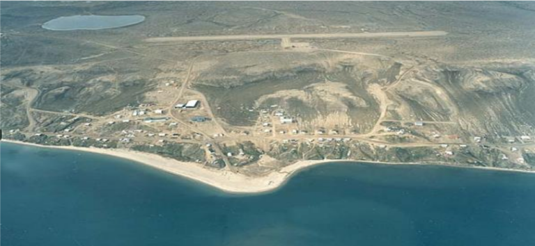
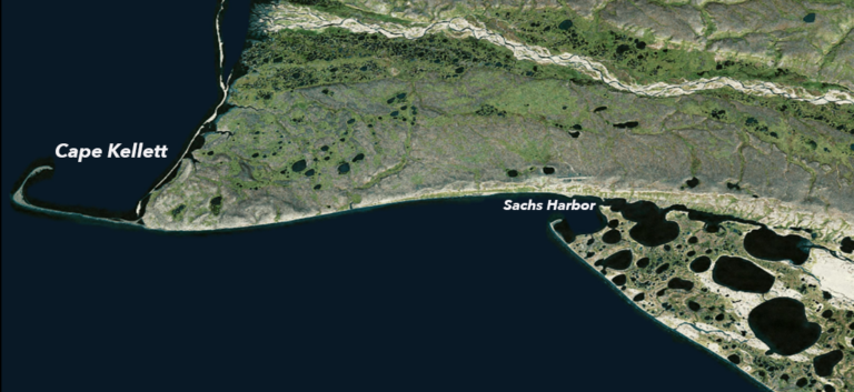
We evaluated an approximately 40 km section of Arctic coastline along southwestern Banks Island from the Cape Kellett spit on the western end extending beyond the eastern segment of Sachs Harbour. The results demonstrate that shoreline movement along the southwestern coast of Banks Island varies alongshore and is colored with distinct zones of both accretion and erosion that are pervasive over differing time periods.
Is shoreline erosion in the region being affected by climate change?
This locale and by extension other areas in the Western Canadian Arctic (e.g. Herschel Island, Tuktoyaktuk) have experienced the deleterious effects of climate change. While the geomorphology of the region acts as a catalyst to overall shoreline movement, the amplified effects of recent climate variability in this region characterized by declining sea ice concentration, elevated ground ice thawing and increasing storm intensity have contributed to accelerated rates of erosion along portions of the southwestern coast. Interestingly however, there are several coastal segments along the southwestern coast that have accreted (gained sediment) over time.
How did the NASA/USGS Landsat data record aid your research?
In addition to employing aerial photos and LIDAR (light detection and ranging) for our analyses, Landsat imagery complemented our database of shorelines allowing us to evaluate rates of change with both historical and contemporary data from multiple sources. The availability and accessibility of remotely sensed digital imagery obtained from Landsat satellites allow coastal scientist—and more importantly community members—the opportunity to map, evaluate and continuously monitor shoreline movement at regular intervals given the unprecedented pace of Arctic climate change.
What are the implications of the landward movement of the shoreline for the residents of Banks Island?
This research presents the residents of Sachs Harbour with updated quantitative information on observed changes over a range of temporal and spatial scales of the coastline in their community.
The results highlight specific regions of the coastline that are susceptible to the effects of climate variability. For example, with models projecting continued decreasing sea ice extent and longer open-water seasons, the impacts of storm-generated waves will likely result in increased coastal erosion and possible inland flooding along certain shoreline segments.
While some areas along the shoreline are eroding, the good news for community members is the persistence of depositional areas fronting the community where the mechanisms of alongshore sediment transport have resulted in accretion in these areas. With the assistance of Dr. Matthews and Dr. Murray, we are developing an ArcGIS storymap to communicate the findings of this research to policymakers and residents from a novel geospatial perspective.
Co-authors:
Kara J Matthews
University of Calgary
Maribeth S Murray
University of Calgary
This research was funded by a University of Calgary “Eyes-High” postdoctoral fellowship.
Further Reading:
+ Landsat at the 2019 AGU Fall Meeting
Anyone can freely download Landsat data from the USGS EarthExplorer or the LandsatLook Viewer.


