Search
Close this search box.

The 50th Anniversary of the EROS Center: Honoring Five Decades of Innovation Through STEM Outreach Activities

The 50th Anniversary of the EROS Center: Honoring Five Decades of Innovation Through STEM Outreach Activities

By Ellie Leydsman McGinty

A Prominent Center for Earth Observation

The Earth Resources Observation and Science (EROS) Center recently celebrated its 50th anniversary from August 17-19, 2023. The EROS Center, located northeast of Sioux Falls, South Dakota, is a federal science center operated by the U.S. Geological Survey (USGS) that was established as a central repository for Landsat (formerly Earth Resources Technology Satellite) imagery, NASA aircraft and spacecraft data, and USGS aerial photography. Throughout its five decades of service, the EROS Center has become the primary steward of remotely sensed land images of the Earth, a pivotal leader in studying the Earth’s land areas and natural resources, and an authoritative provider of land change science data and information. 

The inception of the EROS Center can be traced back to September 21, 1966, when Stewart Udall, then-Secretary of the Interior, issued a press release announcing Project EROS: An Earth Resources Observation Satellite Program. Project EROS was visualized as a collaborative USGS-NASA interagency Earth-observing satellite program that would acquire space-based data for natural and human resource management. After NASA signed the project approval document for the first Earth Resources Technology Satellite (ERTS-1) in January 1969, the USGS recognized the need for a facility that would process, distribute, and archive the data from the mission. Funds were accordingly appropriated in 1970 to build a data center. On March 31, 1970, a site near Sioux Falls, South Dakota, was strategically chosen based on data transmission investigations, socioeconomic needs, and political support. South Dakota Senator Karl E. Mundt was a key factor in generating the financial resources to make the data center possible.

On August 7, 1973, the Karl E. Mundt Federal Building at the EROS Center was dedicated, and on January 1, 1974, the facility became fully operational. By the time the building was dedicated, ERTS-1 (later renamed Landsat 1) had been generating images for over one year. Employees of the EROS Center, who had been working in interim facilities in Sioux Falls, had already processed and produced an average of 25,000 images and photographs per month in response to requests from users all over the world. Within a year of the EROS Center becoming fully operational, imagery, photography, and electronic data from 16 different organizations were being distributed and archived.

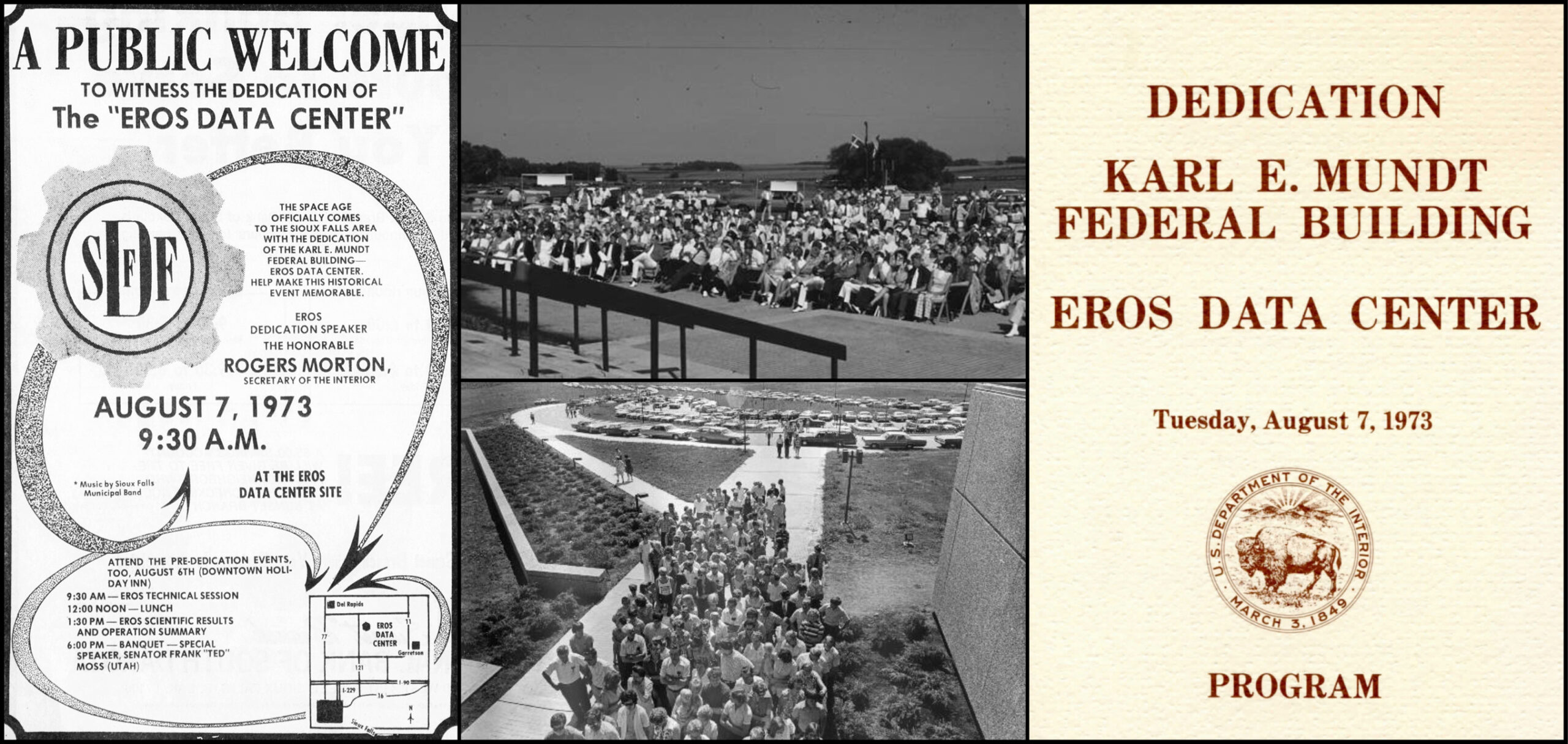
“The EROS Data Center is a product of unique insight and vision. It evidences our efforts to shape our future, by matching the aspirations and spirit of our people with the benefits of our technology. It is a major step—hopefully the first of many—in our quest to understand our environment and ourselves.”
Rogers C. B. Morton
Secretary of the Interior, August 7, 1973
Newspaper advertisement, program cover, and photos from the EROS Center Dedication.
The EROS Center dedication was advertised in the July 29, 1973, issue of the Argus Leader, the daily newspaper of Sioux Falls, South Dakota. On August 7, 1973, 2,000 people attended the opening of the EROS Center. Due to the overwhelming interest, a second event was held on August 12, 1973, which brought an additional 5,000 visitors.

A Landmark Celebration

To commemorate the milestone anniversary of the EROS Center, a three-day celebration was held to honor 50 years of excellence and service to the local community, the nation, and the world. The celebration featured an evening community reception, a ribbon-cutting ceremony, a rededication event, and a “Friends and Family” open house. The open house consisted of special tours, science talks, alumni presentations, and STEM activities. AmericaView, a nationwide network of educators, took the lead in organizing and hosting a STEM event designed to engage learners across all age groups. 

In collaboration with key partners, such as the NASA Landsat Communications and Public Engagement (CPE) Team, the NASA AREN AEROKATS Team, South Dakota State University, and South DakotaView, AmericaView curated several interactive stations for attendees in the USGS EROS Library that provided an overview of remote sensing and underscored the significance of Earth observation. The stations included the following offerings: a table with Landsat outreach materials; a Landsat collage activity; a Frustrationless Flyer kite-building and coloring activity; thermal (FLIR) camera and drone displays; and a demonstration of the STELLA handheld spectrometer. The STEM event had high levels of attendance and engagement, with visitors enjoying hands-on activities and eager to learn more about the Landsat Program and Earth observation.

Photos of the STEM event at the EROS Center 50th anniversary celebration.
As part of the EROS Center 50th anniversary celebration, a STEM event was organized by AmericaView to highlight the value of remote sensing, Earth observation, and the Landsat Program. The event was attended by several hundred people, many of whom engaged in the educational and outreach activities. Photo credits: Christopher McGinty and Lisa Wirth.

A Spotlight on STELLA

During the event, the STELLA handheld spectrometer became a focal point of interest. STELLA (Science and Technology Education for Land/Life Assessment), a portable do-it-yourself (DIY) scientific instrument developed by the Landsat CPE Team, supports remote sensing education and outreach through scientific inquiry and discovery. As a DIY build, students, teachers, and young scientists can gain hands-on experience in science, technology, and engineering as they follow freely available online plans, instructions, and activities. With state-of-the-art sensors, STELLA measures the intensity of light reflected from surfaces across 12 different wavelength ranges in the visible and near-infrared regions of the electromagnetic spectrum. The instrument also encompasses sensors that measure surface temperature (emitted far infrared light). The spectral measurements acquired by STELLA correspond to those collected by sensors on Landsat satellites. 

Attendees of the EROS 50th anniversary STEM event were drawn to the educational value and versatility of STELLA. The device offers a wide range of STEM-based learning activities, from building and programming an instrument to collecting, visualizing, and interpreting real-world scientific data. Guests were inspired by the capabilities and potential applications of the device, as the demonstration provided a foundational understanding of how the sensors on Landsat satellites collect data and how the data can be used to assess vegetation health. The online STELLA Dataviewer provided a platform for displaying, understanding, and exploring the spectral responses from different surfaces and materials. The STELLA augmented reality (AR) promotional card, which allows viewing of a 3D STELLA model on Instagram, served as a fascinating conversation piece and interactive experience.

Screenshot image of the STELLA Dataviewer webpage.
The online STELLA Dataviewer displays the data values that are captured by the sensors on the STELLA handheld spectrometer. The spectral response of a material or surface is displayed on the left side of the screen and the numerical values are shown on the right side of the screen.
An image of the STELLA augmented reality (AR) promotional card with screenshots of the AR filter images.
The STELLA augmented reality (AR) promotional card (center) allows users to scan a QR code and view a 3D STELLA model on Instagram (left). The 3D model can then be exploded by tapping the phone screen to view the primary components of the spectrometer (right).
On Key

Recent Posts

On Key

Related Posts