By Laura E.P. Rocchio
Thursday afternoon at #AGU16, Professor Steve Margulis, a professor of Civil and Environmental Engineering at UCLA gave a talk about his Sierra Nevada snowpack research. Here is what he shared with us:
Presentation Title
Characterizing Snowpack Drought and Drought Recovery in the Sierra Nevada (USA)
What are the major findings of this research?
Our work developed a new snow reanalysis dataset over the Sierra Nevada that leverages the historical Landsat record from 1985-2016.
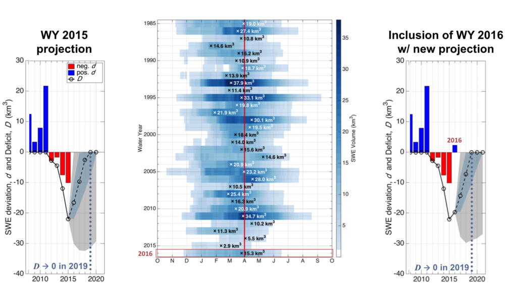
The major findings of this work are that the 2012-2015 snowpack drought in the Sierra Nevada was indeed an extreme event. The water year 2015 peak snowpack was found to be the lowest over the 65-year reconstruction of peak annual snow water equivalent (SWE) and based on a fitted probability distribution had a return period of over 600 years.
At the end of the 2015 water year, when our original study was conducted, we made a probabilistic projection as to how long the snowpack deficit accumulated over the 2012-2015 period would persist. At that time we found that the expected “recovery” would take about 4 years. Based on new analysis for the 2016 water year, we found that despite the fact that 2016 was a non-drought (but below average) year, the deficit is still expected to persist for about 4 years.
What are the implications of your findings?
The primary implication of these findings is that despite 2016 being a non-drought year, we are likely still feeling the persistent impact of the drought due to the historically large deficit built up over 2012-2015. We should therefore be cautious in any assessments that the drought is over.
What insight did you gain from Landsat that would have been impossible to glean otherwise?
Landsat data is assimilated into our estimation system and therefore provides the key constraint on our snowpack estimates. Without Landsat data this analysis would have to be done in a modeling context or using limited in situ data and therefore would have significantly higher uncertainties.
Will (or has) your work been shared with California water managers?
We plan to share the dataset with water managers in hopes it will help improve their forecasting methodologies.

Recovery based on the new end of water year 2016 data. This illustrates that despite the 2016 El Niño, the drought deficit is still not expected to return to zero until 2019.
Co-authors:
Gonzalo Cortés
University of California Los Angeles
Manuela Girotto
NASA Goddard Space Flight Center
Laurie S Huning
University of California Los Angeles
Dongyue Li
Ohio State University Main Campus
Michael T Durand
Ohio State University Main Campus
This work was made possible by the NASA NEWS program.
Anyone can freely download Landsat data from the USGS EarthExplorer or LandsatLook.
Further Reading:
+ Landsat Abounds at #AGU16


