
Jan Friesen is an eco-hydrologist at the Department of Catchment Hydrology of the Helmholtz Centre for Environmental Research – UFZ, in Leipzig, Germany. Here is what Jan shared with us about the work being presented today at #AGU18:
Forest cover dynamics of the Dhofar cloud forest, Oman
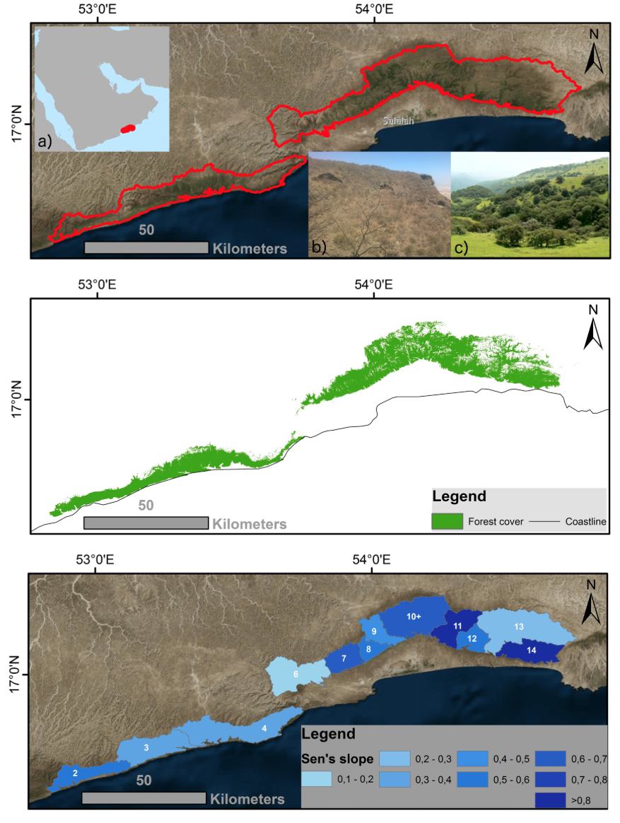
What is a cloud forest?
Cloud forests are forests with a frequent or seasonal low-level cloud cover. Our research focuses on the Dhofar cloud forest which, being situated on the Arabian Peninsula, is a rather unusual seasonal and semi-arid cloud forest—most cloud forests around the globe are lush, evergreen, tropical or subtropical montane cloud forests.
What are the major findings of this research?
(a) Forest cover classification including a spatial aggregation to derive a consistent 30-year forest cover dataset for the Dhofar cloud forest.
(b) Trend analysis shows a stable, and in parts even increasing, cloud forest cover.
(c) Additional water input specific for the Dhofar cloud forest amounts to an additional subcanopy water input of about 15 to 150% of annual rainfall.
What are the implications of your findings?
Our findings show the impact of the cloud forest on available water resources. We show the impact for the past 30 years using Landsat derived forest cover. Our findings could further be used to estimate the effect of de- or afforestation scenarios towards water resources.
What insight did you gain from Landsat that would have been difficult to ascertain otherwise?
The Dhofar Cloud Forest is one of only two closed forests in Arabia on the Arabian Peninsula however, as a forest, it covers a relatively small area that requires at least Landsat’s spatial resolution in order to derive a good forest cover estimate. Current and future satellites have even higher spatial resolutions but only the combination of Landsat’s spatial resolution with its long operation time allows us to generate a substantial 30-year forest cover time series.
See the AGU iPoster here.
Co-authors:
Jan-Karl Haug
Helmholtz Centre for Environmental Research UFZ Leipzig
Romy Arnold
Dresden University of Technology
Anyone can freely download Landsat data from the USGS EarthExplorer or LandsatLook.
Further Reading:
+ Landsat at #AGU18


