The white, monochromatic vistas of Antarctica, a continent practically synonymous with ice, are becoming more verdant—at least around some of its edges. According to an analysis of 35 years of observations from Landsat satellites, the amount of vegetated land on the Antarctic Peninsula has increased more than tenfold since 1986.
As glaciers shrink and temperatures warm, plant life is finding more opportunity to move into this and other cold-climate regions. The expansion of greenery on the Antarctic Peninsula may signal a shift in its ecology, researchers say, raising questions about its future.
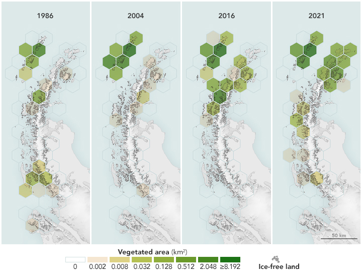
Using observations from Landsat 5 through Landsat 8, scientists determined that the area of vegetated land on the Antarctic Peninsula grew from 0.86 to 11.95 square kilometers (0.33 to 4.61 square miles) between 1986 and 2021. Notably, the expansion of green space accelerated starting in 2016. The research, published in Nature Geoscience in October 2024, was led by environmental scientist Tom Roland of the University of Exeter and remote sensing expert Olly Bartlett of the University of Hertfordshire.
Their results are encapsulated in the maps above. The panels show the amount of green on the peninsula’s ice-free land below 300 meters (1,000 feet) elevation at select years in the study period. The shade of each hexagon corresponds to the amount of land area where levels of plant greenness and density, as determined by the satellite-based Normalized Difference Vegetation Index (NDVI), were high enough to indicate the “almost certain” presence of vegetation. The NDVI values were derived from cloud-free Landsat observations from March of each year, which typically encompasses the end of the growing season. The maps show significant expansion in vegetation cover across the South Shetland Islands (at the top-left of each panel) and down the western side of the peninsula to nearly the southern limit for plant growth.
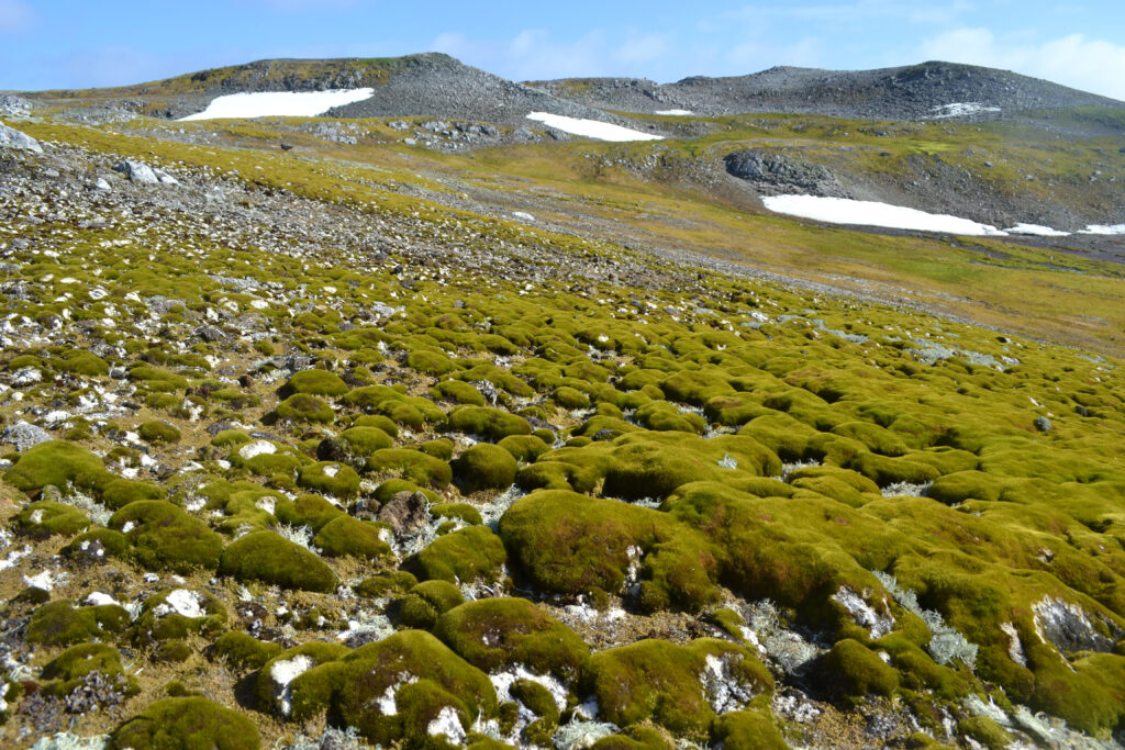
Past field studies on the Antarctic Peninsula have shown that mosses dominate its green areas, forming expansive “carpets,” like on Ardley Island in the photo below, and vertically accumulating “banks.” Both build up layers of new growth each year. In earlier work, Roland and colleagues carbon-dated core samples taken from moss banks along the western side of the peninsula. They discovered that the rates at which moss was accumulating had increased in the past 50 years, indicating an uptick in biological activity amid climatic changes.
These results got scientists wondering if vegetation was not only expanding its territory upward but also outward. So Roland, Bartlett, and their team tapped into the decades-long Landsat record. “Based on the core samples, we expected to see some greening,” Roland said, “but I don’t think we were expecting it on the scale that we reported here.”
The pace of greening was surprising, as well. “When we first ran the numbers, we were in disbelief,” Bartlett said. But the results, based on two different measures of greenness, kept coming out the same. “The rate itself is quite striking, especially in the last few years.”
The Antarctic Peninsula, jutting out into the Southern Ocean from West Antarctica, is one of the fastest warming places on Earth. Most of its glaciers are receding. The uptick in new vegetation in recent years also coincides with a decrease in Antarctic sea-ice extent, an increase in open water, and a strong positive phase in the Southern Annular Mode, which could be producing warmer, wetter conditions, the authors noted.
As plant life finds more favorable conditions for growth on the Antarctic Peninsula, questions about biodiversity in its unique habitats arise. “The narrative in these places has been dominated by glacial retreat,” Roland said. “We’re starting to think about what comes next, after ice recession.” Of particular concern is that where there’s moss, soil formation tends to follow, creating more opportunity for nonnative plants to find a foothold. When that happens, said Bartlett, “you’re looking at potentially an erosion of biodiversity.”
Antarctica hosts hundreds of native species of mosses, liverworts, lichens, and fungi, but only two native species of flowering plants. Human presence on the continent for tourism and research can result in the introduction of nonnative species (although seeds and spores can also arrive on the wind). Several cases of invasions have already been documented in the northern Antarctic Peninsula and nearby islands. “Biosecurity will become increasingly critical as temperature limitations on cold, high-latitude ecosystems decrease,” wrote the researchers.
Now, the scientists are keen to return to the field to understand the changes in finer detail. “We’re at the point that we’ve said the best we can say with the Landsat archives,” Roland said. Many questions remain as to what types of plant communities comprise these new green areas and what shifts in the structure and function of the Antarctic Peninsula’s ecosystems may already be underway. “We need to go to these places where we’re seeing the most distinctive changes and see what’s happening on the ground.”


