
Photo credit: NOAA
By Laura E.P. Rocchio
Lori Schultz with the NASA Short-term Prediction Research and Transition Center (SPoRT), presented a poster today at #AGU16 on the use of satellite remote sensing, including Landsat, to help the National Weather Service with their damage surveys. Here is what Ms. Schultz shared with us:
Presentation Title
Using Satellite Remote Sensing to assist the National Weather Service (NWS) in Storm Damage Surveys
Why is it important to conduct storm surveys after a severe weather event?
The National Weather Service is mandated to perform surveys after a severe weather event. Speaking with NWS Huntsville forecaster, Kris White, he explained that this is answered in NWS directive NWSI 10-1604. The second paragraph in the Introduction sums this up well…
“Information gained from PSDA enables the NWS to increase the knowledge of extreme events, learn how to better use existing equipment, improve NWS warning programs, and provide accurate storm damage information and EF-Scale/Saffir-Simpson Scale ratings to the news media and academia. During long-duration events, such as flooding, data acquisition and overflights may be valuable to both document the event and to enhance ongoing forecast services.”
NWS directive NWSI lays out the framework for dissemination of statements regarding the information obtained during damage surveys. We are mandated to include information about storm length and width. This is, of course, easier to do sometimes with satellite imagery, which can make the overall survey process more accurate especially in rough terrain or areas without a dense road network.
How do multispectral satellite images aid in conducting storm surveys?
Multispectral imagery from satellites (or any remote sensing platform, as available) offers an overhead view to NWS personnel, especially in areas that are rural, forested, or are not accessible by road networks. This information has the potential to give both NWS personnel and the research community a more complete understanding of the storm as well as identify damaged areas that may not have been reported through other channels. This information is then used by others in the community (insurance, emergency management, etc.) to make better informed decisions.
Can you give us an example where Landsat data was helpful?
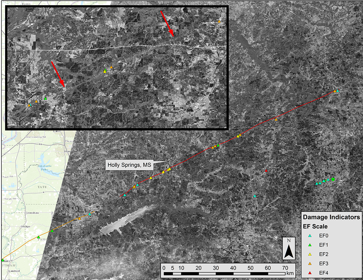
Landsat data is the highest resolution, freely available, satellite imagery that we can offer to the community for this purpose. It is particularly useful for events that produce stronger tornados over a large area. The EF-4 Tornado that affected the Memphis County Warning Area (CWA) on December 23, 2015 is a good example, as the overpass was conveniently timed to provide a first look of the damage track, especially where it passed through a very forested area.
Co-authors:
Andrew Molthan
NASA Marshall Space Flight Center
Kevin McGrath
Jacobs, Inc. / NASA Marshall Space Flight Center
Jordan R Bell
NASA Marshall Space Flight Center
Tony Cole
University of Alabama in Huntsville
Jason Burks
Cooperative Institute for Research in the Atmosphere
Anyone can freely download Landsat data from the USGS EarthExplorer or LandsatLook.
Further Reading:
+ Landsat Imagery Helps Determine Tornado Tracks
+ Landsat Abounds at #AGU16


