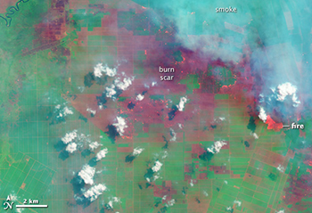
Recently, the Center for International Forestry Research (CIFOR) demonstrated that Landsat 8 data can be used to show fire-affected areas and land-use type. Using spectral information to differentiate oil palm from acacia (a tree used for pulpwood) plantations and visual information to determine land parcel ownership (small/medium land owners with irregularly shaped fields of varying sizes vs. plantations with large regularly shaped rectilinear fields). With a pre-fire image collected on April 22, 2013 and a post-fire image from June 25, 2013, CIFOR discovered that in the region studied industrial plantations accounted for over a fifth of the burned areas and only 4 percent of the burned land occurred in natural forests.
For more details:
+ Nearly a quarter of June fires in Indonesia occurred in industrial plantations, CIFOR
+ Fires and Farms in Indonesia, NASA’s Earth Observatory

A Rendezvous with Landsat
NASA outreach specialists led educators through a workshop on accessing and utilizing Landsat data at the annual Earth Educators’ Rendezvous.


