Dr. Damien Sulla-Menashe is a remote sensing scientist at Indigo Ag. Here is what Damien shared with us about the work he presented Tuesday at #AGU19:
Providing Growers with Real-Time Crop Health Information Using NASA’s Harmonized Landsat Sentinel-2 Product
Why is the Harmonized Landsat Sentinel-2 (HLS) Product crucial to your work?
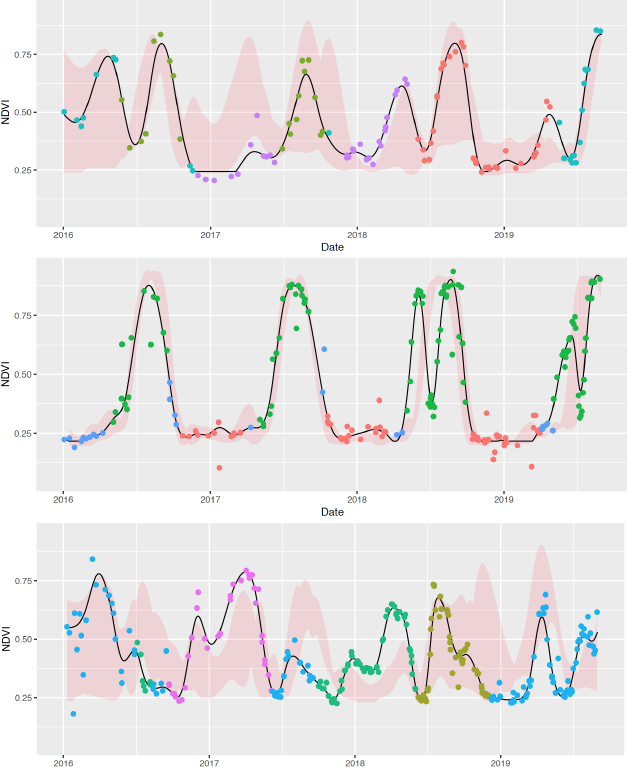
The HLS product is a high quality Earth observation dataset that follows the legacy of MODIS to provide a new standard in Level 3 processing of medium resolution satellite imagery. By bringing both NASA/USGS Landsat 8 and Sentinel-2 sensors together at a 30-m spatial resolution, we see a cloud-free observation over a single location every 3-5 days in many places.
At IndigoAg we have a mission to make growers more money and move the farming industry down a more sustainable path. This year Indigo announced the Terraton Initiative with the long-term objective to draw down one trillion tons of CO2 from the atmosphere into agricultural soils. To do this we will be promoting regenerative agricultural practices along with providing real-time information and agronomic support to farmers during the growing season.
At the end of the supply chain, we have built an auction-house for grain called Indigo Marketplace that is backed by the transportation to bring the harvest directly from the growers to the buyers, who may be interested in particular specialties such as non-GMO, organic, or high-protein.
In order to enable growers to make actionable decisions during the growing season, we will provide them with historical and current imagery and time series data. While we will use Sentinel-2 10-m data for most of our imagery service, HLS data are essential to the time series data summarized at each crop field.
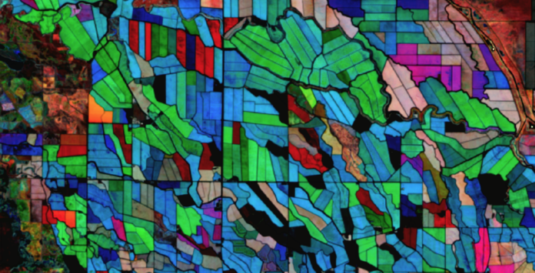
The density of HLS time series enables our GeoInnovation Data Science group to pursue a number of projects including crop type classification, detection of tillage and cover crops, yield modeling, and multi-sensor fusion. The outputs of these will be shown to farmers in our Indigo Fields Web application that will come out next year.
How do growers benefit from this information?
In 2019 we will be enrolling growers in our Indigo Carbon program with the purpose of incentivizing the drawdown of CO2 into agricultural soils by paying farmers by the acre to switch to regenerative agriculture products. To make this feasible and to verify the claim, we will be embarking on a massive data collection campaign to establish a baseline of soil carbon in these fields through measurement and modeling.
The dense time series of the HLS product makes it ideal to detect the use of cover crops, irrigation, and tillage practices, which are essential inputs to the modeling project. HLS also provides an important standard to use for multi-sensor fusion, by adjusting the overlapping Sentinel-2 and MODIS data to this standard facilitates data fusion approaches to greatly improve our time series analyses and imagery services.
Is freely available medium-resolution multispectral data an important resource?
Freely available medium-resolution data processed to a Level 2 or Level 3 standard, are essential for Earth system science and drive advances in agricultural monitoring and measurement.
The continued work to operate the Landsat, Sentinel, and MODIS instruments is critical for the IndigoAg vision and we are grateful to the producers of these high quality data.
Increasingly these data are on the cloud and this facilitates scalable analyses and cheaper post-processing. By downloading these data from a requester-pays bucket on AWS we are able to save many thousands of dollars in accessing over a very small FTP pipe.
Are there future HLS developments that your team would like to see?
We are looking forward to the release of the global data, this is currently preventing us from scaling to match our international needs for Brazil, Argentina, Europe, Australia, and India. The inclusion of a Sentinel-2 10-m data that has bands already converted to the combined Sentinel-2 and Landsat standard would be useful for our imagery service. Improving the cloud masks, especially for the Sentinel-2 component of the product, by using multi-temporal cloud masking algorithms would make the data cleaner and require less post-processing.

Co-authors:
Keith F Ma
Indigo Ag
Bobby H Braswell
Indigo Ag
Mark A Friedl
Indigo Ag
Ophir Horn
Indigo Ag
Any use of trade, firm, or product names is for descriptive purposes only and does not imply endorsement by the U.S. Government.
Further Reading:
+ Landsat at the 2019 AGU Fall Meeting
Anyone can freely download Landsat data from the USGS EarthExplorer or the LandsatLook Viewer.


