
Future Science Products for Landsat Satellite to be Discussed at Landsat Science Team Meeting
Virginia Tech faculty members and graduate students will get to present their remote sensing research to scientists from across the world when the Landsat Science Team meets on the Blacksburg campus Jan. 12-14.
Mosquito Meets MODIS & Landsat: South Dakota Fights West Nile Virus
Source: NASA Video @ YouTube South Dakota is the U.S. hotspot for West Nile disease. Scientists and public health officials there developed a way to use environmental data from
Letter Contract for Landsat 9 Imager-2 Awarded
NASA has awarded a sole source letter contract to Ball Aerospace & Technologies Corporation, Boulder, Colo., to build the Operational Land Imager-2 instrument for the Landsat 9 project.
79 Landsat Images Provided to International Charter, Dec. 2015
The Charter concept is this: a single phone number is made available to authorized parties providing 24/7 contact to a person who can activate the charter. Once activated, a project manager takes charge. The project manager knows what satellite resources are available, how to task them to collect data, and how to quickly analyze the collected data to create impact maps for first responders. These maps, provided to responders for free, often show where the damage is and where crisis victims are, allowing responders to plan and execute relief support.
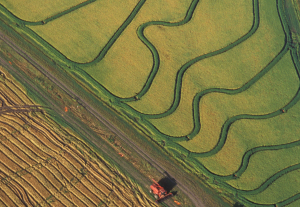
Mapping Rice, Managing Water in Parched California
Liheng Zhong, a Senior Delineator with the California Department of Water Resources is working on a way to map rice fields with Landsat to better manage water use. He presented some of this findings at #AGU15, here’s what he shared with us.
Behind the Rapid Loss of Lakes on the Mongolian Plateau
Shengli Tao, from Peking University, has used the Landsat data archive to map, measure, and investigate the shrinking lakes of the Mongolian Plateau. We spoke to Tao about the work he presented at #AGU15.
Tracking Global Surface Water Dynamics with Landsat
At #AGU15, Amy Hudson, from the University of Maryland College Park, presented a poster about her work to develop a global surface water dynamics map for the years 2000–2014 using data from three Landsat satellites. We spoke with her about this effort.
Measuring Movement at the Bottom of the Earth
Alex Gardner, a Research Scientist at NASA’s Jet Propulsion Laboratory, has used 30 years of Landsat data—some 3 million scenes—to measure the velocity of Antarctica’s ice sheet. He spoke with us about the work he is presenting at #AGU15.
The Mechanics of Meander Migration
Joshua Ahmed from Cardiff University studies how river meanders evolve. Using Landsat data to examine river movement through time, his team has made new observations about river channel change. He presented his findings at #AGU15.
Future Science Products for Landsat Satellite to be Discussed at Landsat Science Team Meeting
Virginia Tech faculty members and graduate students will get to present their remote sensing research to scientists from across the world when the Landsat Science Team meets on the Blacksburg campus Jan. 12-14.
Mosquito Meets MODIS & Landsat: South Dakota Fights West Nile Virus
Source: NASA Video @ YouTube South Dakota is the U.S. hotspot for West Nile disease. Scientists and public health officials there developed a way to use environmental data from
Letter Contract for Landsat 9 Imager-2 Awarded
NASA has awarded a sole source letter contract to Ball Aerospace & Technologies Corporation, Boulder, Colo., to build the Operational Land Imager-2 instrument for the Landsat 9 project.
79 Landsat Images Provided to International Charter, Dec. 2015
The Charter concept is this: a single phone number is made available to authorized parties providing 24/7 contact to a person who can activate the charter. Once activated, a project manager takes charge. The project manager knows what satellite resources are available, how to task them to collect data, and how to quickly analyze the collected data to create impact maps for first responders. These maps, provided to responders for free, often show where the damage is and where crisis victims are, allowing responders to plan and execute relief support.
Mapping Rice, Managing Water in Parched California
Liheng Zhong, a Senior Delineator with the California Department of Water Resources is working on a way to map rice fields with Landsat to better manage water use. He presented some of this findings at #AGU15, here’s what he shared with us.
Behind the Rapid Loss of Lakes on the Mongolian Plateau
Shengli Tao, from Peking University, has used the Landsat data archive to map, measure, and investigate the shrinking lakes of the Mongolian Plateau. We spoke to Tao about the work he presented at #AGU15.
Tracking Global Surface Water Dynamics with Landsat
At #AGU15, Amy Hudson, from the University of Maryland College Park, presented a poster about her work to develop a global surface water dynamics map for the years 2000–2014 using data from three Landsat satellites. We spoke with her about this effort.
Measuring Movement at the Bottom of the Earth
Alex Gardner, a Research Scientist at NASA’s Jet Propulsion Laboratory, has used 30 years of Landsat data—some 3 million scenes—to measure the velocity of Antarctica’s ice sheet. He spoke with us about the work he is presenting at #AGU15.
The Mechanics of Meander Migration
Joshua Ahmed from Cardiff University studies how river meanders evolve. Using Landsat data to examine river movement through time, his team has made new observations about river channel change. He presented his findings at #AGU15.
