Dr. Emily Fairfax is an Assistant Professor in the department of Environmental Science and Resource Management at California State University Channel Islands. Here is what Emily shared with us about the work she is presenting today at #AGU19:
Smokey the Beaver: Can Beaver Dams Help Protect Riparian Vegetation During Wildfire?
What are the major findings of this research?
As the global temperature rises, some areas are experiences increasingly severe droughts and wildfires. Vegetation and soil—especially in the American West—becomes exceptionally dry as heat and lack of precipitation persists through the summer and into the fall months. It’s that dry vegetation that is so readily ignited by lightning, campfires, power lines, etc. Once these wildfires get going, they can be challenging to control and can burn 10’s – 100’s of thousands of acres.
Wetlands and riparian zones are notoriously sensitive ecosystems. While the vegetation in them is typically quite resilient to disturbance, if you are a fish, frog, or salamander your chances of escaping a wildfire are slim. The western US has already lost the vast majority of its wetlands, so a single large fire could be the difference between survival and extinction for some threatened wetland species. But what if they didn’t have to escape the fires? What if there were patches of cool, wet, green vegetation they could hunker down in and wait it out?
Beavers are well known for being busy ecosystem engineers. They build dams in streams all across North America, as well as in parts of Europe and Asia. Their dams create the ponds and wetlands that the beavers live in, as well as provide habitat for an abundance of other aquatic, semi-aquatic, and avian species. The large volume of water stored in the beaver ponds and active pond management by the beavers keeps plants and soil lush and green even during intense droughts. Then, when fires spark in these drought-stricken areas the wet, green beaver-dammed wetlands are too soggy to burn. It’s very similar to the mechanics behind why you can’t easily start a campfire using wet leaves and sticks.
We found that in five recent large wildfires in the western US, the riparian areas with beaver damming experienced on average only a 19% reduction of NDVI (Normalized Vegetation Difference Index, essentially plant greenness) during the fires, while similar riparian areas without beaver damming experienced on average a 51% reduction of NDVI. The difference between the areas with and without beaver damming was statistically significant, which suggests that the beaver-dammed riparian areas are functionally different in how they respond to fire. So if you are one of those sensitive wetland critters, like a fish, frog, or salamander, you don’t have to escape the whole wildfire – you just need to get to the nearest beaver pond and wait it out.
How can landscape managers in wildfire-prone regions use this information?
Fire is a natural part of many ecosystems and shouldn’t be suppressed altogether, but given how little wetland area we have left it is prudent to actively support its preservation. Simply allowing beavers to build dams and occupy watersheds can be a big step in preserving wetland habitat even in exceptionally large fires (the largest in our study was 395,000 acres!), and it requires very little financial or human resources.
The work that beavers do in a landscape helps restore the natural processes that increase ecohydrologic resiliency to a variety of environmental stressors, including drought, fire, and flooding. A single family of beavers can occupy and protect several kilometers of riparian area all for the low cost of some trees and being left alone. Scale that up to a hundred or a thousand beaver families, and suddenly almost every waterway in the region will have patches of fireproof beaver wetland ready to act as a refuge for flora and fauna.
Why did you choose to work with NASA/USGS Landsat data for this study?
Landsat data was perfect for this study for several reasons. First, we needed data that went back almost 20 years. Second, we needed data that was high enough resolution to discern beaver-dammed wetlands from the surrounding landscape. Third, we needed data that covered large areas and was available across the western US. Fourth, we needed a relatively frequent data collection interval – at least once a month. Finally, we needed data that contained enough bands of reflectance to evaluate various vegetation indices in our study areas. Landsat fit all our criteria, and best of all it was free and very easy to download and work with.
Not every project is going to have a large budget, and many of the people who might be interested in managing or working with beavers to create climate resiliency are practitioners. By only using free, readily available data in our study, we both quantified the impact that beavers were having in the landscape during fire, as well as demonstrated how to evaluate the impact beavers in any landscape without needing significant financial resources or specialized equipment.

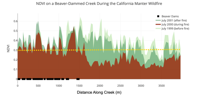
Shown here is the NDVI (Normalized Vegetation Difference Index) in the riparian zone of the creeks within the burn area of the 2000 Manter Fire in California from the summer in the year before, the year during and the year after the fire. Marked with black boxes along the x-axis are the locations of beaver dams.
The NDVI data from the years before and after the fire are shown in shades of green, and the NDVI data from during the fire is shown in red/brown. The dashed yellow line marks an NDVI of 0.3, which is generally considered to be indicative of unhealthy, dead, or senescing vegetation.
Note that the portions of the stream where beaver dams are present had very little variation in NDVI across the three years, while the portions of the stream without beavers had a large reduction in NDVI during fire.
This indicates that beaver-dammed riparian zones can maintain green, living vegetation even during wildfires while riparian zones without beaver tend to burn. This result was observed in five different fires across the western
US. Image credit: Fairfax & Whittle – AGU19
Emily’s stop-motion video: Beavers and Wildfire
Co-authors:
Andrew James Whittle
Colorado School of Mines
Further Reading:
+ Are Beavers Nature’s “Little Firefighters”? Eos
+ Landsat at the 2019 AGU Fall Meeting
Anyone can freely download Landsat data from the USGS EarthExplorer or the LandsatLook Viewer.


