News Archives
![monkey tree](https://landsat.gsfc.nasa.gov/wp-content/uploads/2018/11/monkey_tree-th.pmg_.png)
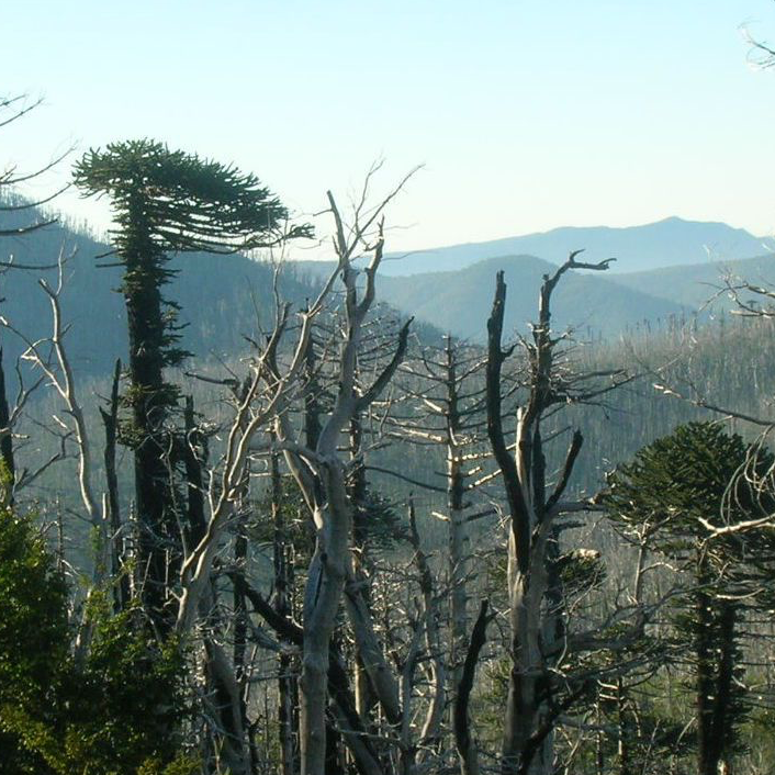
Looking at Burn Severity and Post-Fire Forest Regeneration in Chile’s Andean Cordillera, Home to the Monkey Puzzle Tree
The first study that connects field-measured data with satellite-derived burn severity in this corner of the world.
USGS Burned Area Products Group in Denver Touts Value of Landsat ARD
A new Burned Area algorithm has been developed by USGS to identify burned areas in images across the Landsat archive.
Despite Recovery, Widespread Evidence of Deforestation Remains a Half-Century Later
The patterns of large-scale tropical deforestation endure across landscapes, even after more than a half-century of tropical rainforest expansion and growth.
"Landsat 10-Era" Concepts Wanted
NASA and USGS are seeking information on system concepts and innovative approaches for its second Sustainable Land Imaging Architecture Study.
Q&A with Tim Newman: A USGS Look at Landsat's Potential Future
Source: USGS EROS When it comes to the business of acquiring remotely sensed data, of preserving that data and providing a portal to it, National Land Imaging Program Coordinator Tim
AmericaView Secures 5-Year USGS National Land Imaging Grant
A five-year, $6.25 million dollar grant to support nationwide remote sensing education, outreach, and research has been granted to AmericaView.
Review Panels Ensure USGS, NASA Don’t Pay ‘the Price of Failure’ with Landsat 9
Agencies like NASA and the U.S. Geological Survey (USGS) that commit multiple millions of dollars to put Landsat satellites into space need to know that the spacecraft, the sensors onboard, the ground system operating the satellite, and the launch vehicle are all designed and built the right way.
The Lewis and Clark Trail from Space
Explore the Lewis and Clark National Historic Trail with an interactive storymap.
News Archives
Upcoming ARSET Webinar: Change Detection for Land Cover Mapping
NASA’s Applied Remote Sensing Training (ARSET) group will be hosting a two-day data training webinar.
Summer 2018 Landsat Science Team Presentations Available
Summer 2018 Landsat Science Team presentations have been made available by USGS.
Landsat Used To Predict Tree Species Distributions in Peruvian Lowland Amazonia
Researchers have succeeded in producing distribution maps for a selection of important tropical tree species in Peruvian lowland Amazonia.
Reading the Tides: Monitoring Estuarine Habitats in Northern Australia with Landsat
Australian researchers have used Landsat imagery to map coastal habitats critical to threatened and migratory species in northern Australia.
USGS Video: Landsat in Action—Water Use with Molly Maupin and Gabriel Senay
Find out how Landsat imagery has been used by the National Water Census and in studying water use trends.
Evaluating Effects of Land Use Change on Watershed Health and Carbon Sequestration in Costa Rica's Osa Peninsula
This project used Landsat 5 and Landsat 8 data to create land use maps to analyze change in riparian case study areas.
Where Rivers Meet the Sea—Envisioning Science with Landsat
A Landsat 8 image of the Suwannee River meeting the Gulf of Mexico took first place in this year’s Envisioning Science image competition held by NC State.
Landsat 9 Ground System Moves from Design to Development and Beyond
The final Landsat 9 Ground System Critical Design Review is being hosted by USGS EROS at the end of September.
Landsat Sees 30 Years of Yellowstone Recovery from 1988 Fires
A combination of lightning, drought and human activity caused fires to scorch more than one-third of Yellowstone National Park in the summer of 1988.