
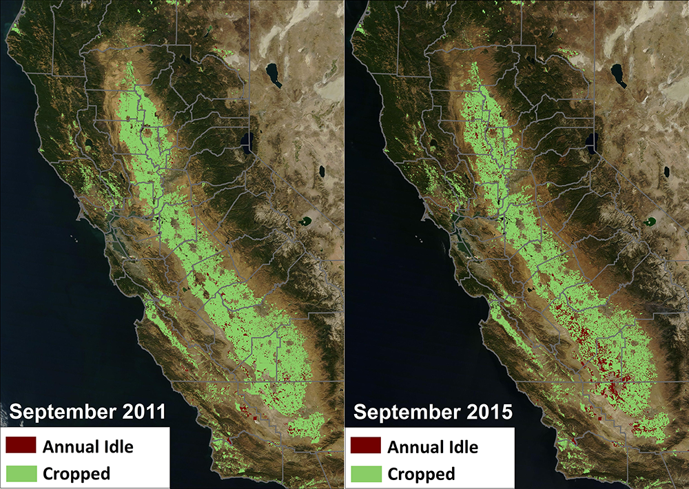
Federal Agencies Release Data Showing California Central Valley Idle Farmland Doubling During Drought
NASA, in collaboration with the United States Department of Agriculture (USDA), United States Geological Survey (USGS), and the California Department of Water Resources, released data today showing the effect the current drought has had on agricultural production and the idling of California farmlands.
United States and European Union Sign Cooperation Arrangement on Copernicus Earth Observation Data
The European Commission and the United States signed the “Copernicus Cooperation Arrangement” which will facilitate data sharing from the Copernicus constellation of Sentinel Earth Observation satellites among a broad spectrum of users on both sides of the Atlantic.
The Chesapeake Bay in 661 Million Pixels
Imagine you’re flying 438 miles above the Earth taking pictures and collecting information of everything below. What do you see? Now imagine you’ve been doing this non-stop for over 40 years. Do you notice any change?
Tracking Agricultural Water Use on a Smartphone
This fall scientists at the University of Nebraska, with partners at Google Inc., the University of Idaho and the Desert Research Institute, introduced the latest evolution of METRIC technology—an application called EEFLUX, which will allow anyone in the world to produce field-scale maps of water consumption.
Barrier Island Shorelines Extracted From Landsat Imagery
Landsat enables coastal geomorphologists to observe changes to barrier islands on annual and decadal time scales—providing information about island size, shape and position, as well as erosion, land loss and island breakup.
NASA LCLUC Spring 2015 Science Team Meeting Summary
The NASA Land-Cover/Land-Use Change (LCLUC) Program held its annual spring Science Team Meeting (STM) on April 22-23, 2015, in College Park, MD.
A forest by any other name? Semantics, carbon implications, and solutions
Using the world’s first global, Landsat-based 30-meter resolution map of tree cover, researchers found that ambiguity of the term “forest” has the potential to create 13 percent discrepancies in forest area maps. While ecologists have long understood the complexity comprised by the concept of “forest”, and while geographers have called for the term to be more uniformly defined across monitoring entities, no one had quantified the scope of the problem.
Over 150 Landsat Images Provided to the International Charter in September 2015
This month, 166 Landsat scenes were ingested by the USGS Hazard Data Distribution System to provide data for Charter activations.
Landsat Images Advance Watershed Restoration in Western Tanzania
For those who live along its shores, Lake Tanganyika in east Africa is the backbone of local transportation and serves as an essential source of household water and protein. Every night, fishers lure nocturnal, sardine-like fish called dagaa with compression lamps that are strung between their boats. From the shore, the lake sparkles with the lights of miniature moons as people gather the treasured catch.
