NASA LCLUC Spring 2015 Science Team Meeting Summary
The NASA Land-Cover/Land-Use Change (LCLUC) Program held its annual spring Science Team Meeting (STM) on April 22-23, 2015, in College Park, MD.

The NASA Land-Cover/Land-Use Change (LCLUC) Program held its annual spring Science Team Meeting (STM) on April 22-23, 2015, in College Park, MD.
Using the world’s first global, Landsat-based 30-meter resolution map of tree cover, researchers found that ambiguity of the term “forest” has the potential to create 13 percent discrepancies in forest area maps. While ecologists have long understood the complexity comprised by the concept of “forest”, and while geographers have called for the term to be more uniformly defined across monitoring entities, no one had quantified the scope of the problem.
For those who live along its shores, Lake Tanganyika in east Africa is the backbone of local transportation and serves as an essential source of household water and protein. Every night, fishers lure nocturnal, sardine-like fish called dagaa with compression lamps that are strung between their boats. From the shore, the lake sparkles with the lights of miniature moons as people gather the treasured catch.
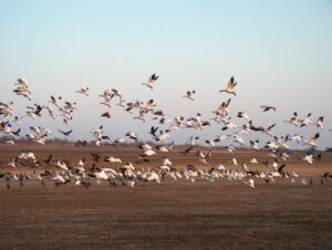
The BirdReturns program, created by The Nature Conservancy of California, is an effort to provide “pop-up habitats” for some of the millions of shorebirds, such as sandpipers and plovers, that migrate each year from their summer breeding grounds in Alaska and Canada to their winter habitats in California, Mexico, Central and South America.
The world lost more than 18 million hectares (45 million acres) of tree cover in 2014, an area twice the size of Portugal, according to new data from the University of Maryland (UMD) and Google released by Global Forest Watch. The data find that tropical forests are in the most trouble, losing 9.9 million hectares (24.5 million acres) of tree cover in 2014 – over half of the global total. A three-year-average shows tree cover loss is the highest it’s been since 2001.
The 2.38 million Landsat images freely downloaded in 2011, benefited the U.S. economy by $1.8 billion found a new study published this month by a team of economists from Colorado State University and the USGS Fort Collins Science Center.
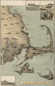
The sandy peninsula of Cape Cod, Massachusetts juts into the Atlantic Ocean with its characteristic crook and twirl in both images: “Balloon View–Nantucket to Boston” made in 1885, and a Landsat 8 satellite image made 129 years later in 2014. Aspirations to rise above the Earth and to record the Earth’s surface from there are a long-standing theme of human culture.
Cities are well known hot spots – literally. The urban heat island effect has long been observed to raise the temperature of big cities by 1 to 3°C (1.8 to 5.4°F), a rise that is due to the presence of asphalt, concrete, buildings, and other so-called impervious surfaces disrupting the natural cooling effect provided by vegetation. According to a new NASA study that makes the first assessment of urbanization impacts for the entire continental United States, the presence of vegetation is an essential factor in limiting urban heating.
Forest resource managers, natural resource policy makers, and global change scientists need comprehensive, consistent, and up-to-date information on trends in forest cover and condition. This information is essential for understanding carbon budgets, predicting fire behavior, quantifying biodiversity, and hydrologic modeling.
The Social and Economic Analysis team at the Fort Collins Science Center recently added five new agriculture focused case studies to their “Landsat Imagery: A Unique Resource” website.
Algae are complicated. The little plants can be both good and bad.

On the most recent nautical chart of the Beaufort Sea where the long narrow Tapkaluk Islands of Alaska’s North Slope separate the sea from the shallow Elson Lagoon (Nautical Chart 16081) a massive shoal is immediately noticeable just west of the entrance to the lagoon. On the chart it looks like a massive blue thumb jutting out into the sea. The National Oceanographic and Atmospheric Administration (NOAA) identified this prodigious, 6-nautical mile-long, 2-nm-wide shoal using Landsat satellite data.
On Tuesday, Mapbox announced that it is at work incorporating atmospherically corrected Landsat 8 data into its constantly refreshed Landsat-live map. After ironing out a few remaining kinks, data processed through this automatic atmospheric correction will be incorporated into the publicly available Landsat-live layer.
Hydrologists from the University of North Carolina have come up with an innovative way to estimate the size of rivers via satellite images. Combing through data acquired by Landsat satellites, George Allen and Tamlin Pavelsky have compiled a new database of river widths for North America.
Researchers and citizens have known for some time that Turkey’s glaciers are shrinking. Now scientists have calculated the losses and found that more than half of the ice cover in this mountainous country has vanished since the 1970s.
The European Space Agency’s Sentinel-2A successfully launched into orbit last night from Europe’s Spaceport in Kourou, French Guiana aboard a Vega rocket (10:52 p.m. local time; 01:52 GMT).
![The sensors aboard Landsat 8 were designed to have higher sensitivity to brightness and color; they use 4,096 values to digitize their signals (12-bit data) whereas the last-generation sensor on Landsat 7 was slightly less sensitive and used only 256 data values (8-bits) to describe the range of brightness it recorded. Visually, this translates into a smoother, less noisy looking images as can been seen here when comparing these natural color Landsat 7 [left] and Landsat 8 [right] images of the extensive coral reefs on the northern shore of Vanua Levu, Fiji’s second largest island, acquired on September 19, 2002 and May 10, 2015, respectively.](https://landsat.gsfc.nasa.gov/wp-content/uploads/2015/06/Levu_Fiji_L8_sm-1-300x127.jpg)
With Earth-observing satellite data, scientists can now monitor the health of coral reefs, even in the most remote regions scattered around the globe where it is otherwise difficult to see changes.
In his lightning talk Lagomasino proposed a challenge to help study deforestation by linking satellite imagery and ground-images gathered via crowdsourcing
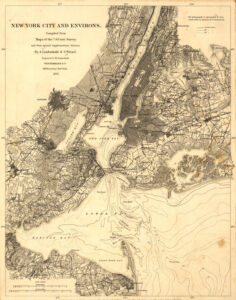
New York City in 1860 was thriving for some of the same reasons the city thrives today. The city’s location was then, and is now, central for the movement of people and freight to and from Europe and elsewhere. Waterways were the primary transportation pathways in 1860. New York’s deep and well-connected port, nearer to the ocean than the ports of other cities on the East coast of the United States, was a huge boon to shipping. The Hudson River connected New York City’s port to a wide gateway westward through the Erie Canal to Lake Erie and beyond. Europe sent and received goods and people across the Atlantic Ocean to New York. Cities on the Great Lakes could enjoy the benefits of shipping to and from Europe, completely by water!
As part of a NASA-associated program, Michael Geiswhite and 28 of his 11th grade students from North Schuylkill Junior-Senior High School studied a coal mine fire that ignited in 1962 in Centralia, PA and forced the permanent exodus from their homes of more than 1,000 people, including some of the students’ relatives.
Dr. Martin O’Leary is a glaciologist with Wales’ Swansea University. He spends most of his time modeling glacier movements and from time-to-time he uses Landsat data to check things out, to get a lay of the land—or glacier. As a pet project he conceived of @LandsatBot, an automated twitter account that tweets interesting looking Landsat 8 images each hour. We recently spoke with Dr. O’Leary about @LandsatBot.
The magnitude 7.8 Gorkha earthquake that struck Nepal on April 25, 2015, caused extensive damage in Kathmandu Valley and severely affected Nepal’s rural areas. Space agencies around the world are providing extensive resources in a huge international effort. They are tasking their satellites to observe the areas hit by the earthquake. This effort began immediately after the disaster.

Last Thursday, Amazon Web Services (AWS) announced that it is now hosting Landsat 8 imagery on its publicly accessible Simple Storage Service (S3).
Landsat is a key data input for many products developed and used in water resources, agricultural monitoring, land use and land cover monitoring, forest management, and development planning.
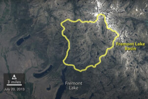
A NASA study of a basin in northwestern Wyoming revealed that the snowmelt season in the area is now ending on average about sixteen days earlier than it did from the 1970s through the 1990s.
The federal government has invested billions of dollars to ensure our country’s leadership in space-based observations of our planet. We need a workforce that is fully prepared to understand and use this data for solving problems of local, national and global concern. Community colleges provide fertile ground for remote sensing workforce development at an effective technician level. They serve almost half the undergraduate students in the United States, and they are well positioned to increase workforce diversity. Nearly half of all Hispanic/Latino and Pacific Islander/Asian students, 36% of African American students, and 42% of Native American/ Native Alaskan students attend a two-year public institution (U.S. Department of Education 2009).
Scientists for the first time have simultaneously compared widespread impacts from two of the most common forest insects in the West—mountain pine beetle and western spruce budworm – an advance that could lead to more effective management policies.

The rate at which tropical forests were cut, burned or otherwise lost from the 1990s through the 2000s accelerated by 62 percent, according to a new study which dramatically reverses a previous estimate of a 25 percent slowdown over the same period. That previous estimate, from the U.N.’s Food and Agriculture Organization’s (FAO) Forest Resource Assessment, was based on a collection of reports from dozens of countries. The new estimate, in contrast, is based on vast amounts of Landsat image data which directly record the changes to forests over 20 years.
Two years ago today, Landsat 8 blasted off from Vandenberg Air Force Base!
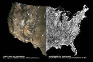
USGS released provisional Landsat surface reflectance products in December. Surface reflectance products correct for atmospheric distortions thereby providing “less hazy” images.
When viewed from space, clouds largely obscure the Earth. It isn’t a matter of time of day, angle or distance. It’s just the way it is – unless, of course, you are gazing at the planet using Google Earth. The story of how Google Earth offers images of the planet — without letting clouds get in the way — began in the foothills of the Santa Cruz Mountains in California.
Turkana County in northwest Kenya has been reeling from several years of crippling drought. As a consequence, the nomadic peoples in the region have suffered. Livestock such as goats and cattle, the sole source of income for these pastoralists, have perished by the droves from starvation, and the resulting economic hardship has left many children malnourished. Many have also died from violent clashes over increasingly scarce resources.
