The Mechanics of Glacier Motion
Using Landsat 8 to document glacier velocity patterns on a mountain-range-wide scale.

Using Landsat 8 to document glacier velocity patterns on a mountain-range-wide scale.
Louisiana’s coastal marshes are responding to climate change.
The authors use Landsat imagery collected between 1996–2016 to analyze trends and variability in snow/ice albedo over the Himalayas.
The potential impacts of climate change on the Hamlet of Paulatuk in the Canadian Arctic are erosive.
Mangrove expansion has been observed in some subtropical locations around the world.
Mr. Chuter presented a poster on new mass balance estimates and velocity changes for parts of West Antarctica.
Glaciologist and prolific AGU blogger, Mauri Pelto, regularly publishes posts about changing glaciers around the globe on his “From a Glacier’s Perspective” blog. In many cases, Landsat data informs his posts.
Scientists at the University of Georgia’s Marine Institute at Sapelo Island have found that the amount of vegetation along the Georgia coast has declined significantly in the last 30 years, spurring concerns about the overall health of marshland ecosystems in the area.
Even with this winter’s strong El Niño, the Sierra Nevada snowpack will likely take until 2019 to return to pre-drought levels, according to new research.
Forests are commodities. The biggest driver of deforestation worldwide is the economic value of trees and the land they stand on. With the high demand for agricultural land and wood products, deforestation has become an intractable problem.
A NASA-led team of scientists has developed the first-ever method for detecting the presence of different types of underground forest fungi from space, information that may help researchers predict how climate change will alter forest habitats.
Alex Gardner, a Research Scientist at NASA’s Jet Propulsion Laboratory, has used 30 years of Landsat data—some 3 million scenes—to measure the velocity of Antarctica’s ice sheet. He spoke with us about the work he is presenting at #AGU15.
Carson Baughman, a geographer at the USGS Alaska Science Center, presented results of his study on seasonal glacial sediment plumes in Alaska’s Lake Clark at #AGU15. We talked to Carson about his work.
Alex Burton-Johnson, Martin Black, and Peter Fretwell from the British Antarctic Survey have used Landsat 8 data to create a new rock outcrop map for Antarctica, which will become part of the Antarctic Digital Database. The team presented their research at #AGU15.
David Selkowitz, a Research Geographer with the USGS Alaska Science Center, and his team have developed a snow cover product, that allows users to look at historical snow cover through time. Selkowitz presented a poster on the Landsat-based data product at #AGU15. Here’s what we learned from him this week.
William Kochtitzky, a student from Dickinson College, presented a poster on glacial changes on Peru’s Nevado Coropuna volcano at #AGU15.
Chengquan Huang presented a poster explaining where to find U.S. forests that have been undisturbed for last 25 years at #AGU15. His research relied on Landsat to both find these forests and understand forest disturbance trends in the U.S.
Martin Goldhaber gave a talk about how climate change will impact the hydrochemistry of wetlands in an immensely important ecosystem known as the Prairie Pothole Region at #AGU15. Landsat data helped Goldhaber track how the size of the waterbodies in his study area changed between 1973 and 2011. Here’s what he shared with us about his research.
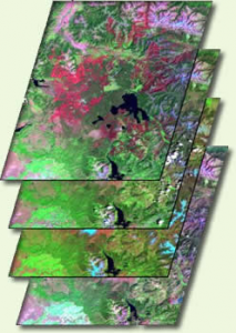
Capitalizing on the long Landsat data record and the human brain’s capacity to recognize movement, Frank Paul from the University of Zurich has created glacier animations that enable viewers to witness the complex flow of glaciers.
Every part of the mosaic of Earth’s surface — ocean and land, Arctic and tropics, forest and grassland — absorbs and releases carbon in a different way. Wild-card events such as massive wildfires and drought complicate the global picture even more. To better predict future climate, we need to understand how Earth’s ecosystems will change as the climate warms and how extreme events will shape and interact with the future environment.
Ice sheets are in perpetual motion, making their way downslope like a river. If the amount of snow that an ice sheet accumulates does not keep pace with its loss to the sea, sea level will rise. As temperatures have climbed, positive feedback loops have led to an accelerated loss of ice sheet sections that touch the sea, but in an unexpected twist to the global warming saga, scientists have just discovered a negative feedback loop that is slowing down the Greenland Ice Sheet sections that end on land—a sliver of good news for sea-level rise.
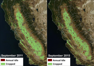
NASA, in collaboration with the United States Department of Agriculture (USDA), United States Geological Survey (USGS), and the California Department of Water Resources, released data today showing the effect the current drought has had on agricultural production and the idling of California farmlands.
Using the world’s first global, Landsat-based 30-meter resolution map of tree cover, researchers found that ambiguity of the term “forest” has the potential to create 13 percent discrepancies in forest area maps. While ecologists have long understood the complexity comprised by the concept of “forest”, and while geographers have called for the term to be more uniformly defined across monitoring entities, no one had quantified the scope of the problem.
The world lost more than 18 million hectares (45 million acres) of tree cover in 2014, an area twice the size of Portugal, according to new data from the University of Maryland (UMD) and Google released by Global Forest Watch. The data find that tropical forests are in the most trouble, losing 9.9 million hectares (24.5 million acres) of tree cover in 2014 – over half of the global total. A three-year-average shows tree cover loss is the highest it’s been since 2001.
Researchers and citizens have known for some time that Turkey’s glaciers are shrinking. Now scientists have calculated the losses and found that more than half of the ice cover in this mountainous country has vanished since the 1970s.
As part of a NASA-associated program, Michael Geiswhite and 28 of his 11th grade students from North Schuylkill Junior-Senior High School studied a coal mine fire that ignited in 1962 in Centralia, PA and forced the permanent exodus from their homes of more than 1,000 people, including some of the students’ relatives.
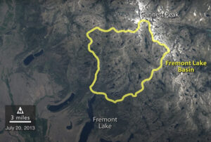
A NASA study of a basin in northwestern Wyoming revealed that the snowmelt season in the area is now ending on average about sixteen days earlier than it did from the 1970s through the 1990s.

The rate at which tropical forests were cut, burned or otherwise lost from the 1990s through the 2000s accelerated by 62 percent, according to a new study which dramatically reverses a previous estimate of a 25 percent slowdown over the same period. That previous estimate, from the U.N.’s Food and Agriculture Organization’s (FAO) Forest Resource Assessment, was based on a collection of reports from dozens of countries. The new estimate, in contrast, is based on vast amounts of Landsat image data which directly record the changes to forests over 20 years.
Ecosystems provide vast services and benefits to humankind: food and water that is needed for survival; nutrients and other natural products that fuel farms and industries; natural controls on many pests and pathogens; storage of carbon safely out of the atmosphere; shared spaces for tourism and recreation; and sanctuaries that preserve biodiversity, natural beauty, and cultural history.
Along the sea’s edge in Bangladesh, India, Pakistan, and Sri Lanka, the dense coastal population lives largely in symbiosis with the region’s mangrove forests.
Mangroves—a vast network of intertidal trees and shrubs with their characteristic tangle of above ground roots—give safety, sustenance, and spectacle to coastal denizens in a multitude of ways. Namely, by stabilizing shorelines, safeguarding water quality, influencing stable microclimates, controlling flooding, and providing transportation, forest products, hunting and fishing grounds, and recreation and protecting people and property from storms.
A group of researchers from the University of Maryland, the Indonesian Ministry of Forestry, and the World Resource Institute joined forces to remedy the lack of consensus about the amount of old-growth forest clearing occurring in Indonesia.
A compendium of civilian satellites with the potential to image global land surfaces has been compiled by Alan Belward and Jon Skøien from the Land Resource Management Unit of the European Commission’s Institute for Environment and Sustainability. Results of this work were published online on April 28, 2014 in the Journal of Photogrammetry and Remote Sensing.
An international team led by glaciologists from the University of Colorado Boulder and Trent University in Ontario, Canada has completed the first mapping of virtually all of the world’s glaciers—including their locations and sizes—allowing for calculations of their volumes and ongoing contributions to global sea rise as the world warms.