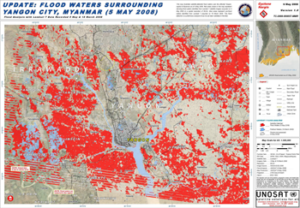
UNOSAT Maps Flood Extent Near Lake Urmia with Landsat 8
A Landsat 8-based map showing regions south of Iran’s Lake Urmia that have been effected by recent flooding has been created for UN decision makers.
A Landsat 8-based map showing regions south of Iran’s Lake Urmia that have been effected by recent flooding has been created for UN decision makers.
Using Landsat 8 to create three-dimensional maps of volcanic ash plumes.
In May 2015, a severe glacier surge struck the eastern Pamir.
Imagery, like Landsat’s, offers an overhead view to NWS personnel.
A new collaborative platform has been developed to help Vietnam plan for and respond to flooding.
Developing the largest database of spatial extents for historic floods.
Analyzing a three-decade record of vegetation cover change from the Landsat to compare previous controls on Sierra Nevada forest growth rates and effects of recent fluctuations in water availability since the mid-1980s.
NASA and the U.S. Geological Survey’s Landsat satellite images over the past three decades showed that the severe drought periods recorded since the 1980s have not slowed rapid tree and shrub growth, especially on steep slopes burned recently by wildfires.
On December 23, 2015, an unusual early winter season tornado outbreak struck much of the Tennessee Valley.
Naga Manohar Velpuri, works with the USGS Famine Early Warning Systems Network (FEWS NET). The project has recently initiated a large-scale project to monitor surface water bodies in the pastoral regions of Africa using multi-source satellite data and hydrologic modeling techniques. Currently, a total of 293 water points are being monitored in 10 countries. Velpuri shared some of the projects findings he presented at #AGU15.
Justin Roberts-Pierel from the Joint Center for Earth Systems Technology, uses Landsat 8 to detect landslides in the Himalayas. He provided information about his studies at #AGU15. We talked with him about his work.
Alex Riter, a graduate student at the University of Maryland College Park, presented her finding on how Hurricane Sandy affected New Jersey coastal marches at #AGU15. We talked to Riter about her research.
At #AGU15 Yurika Kato, a Geosciences graduate student at the University of Missouri-Kansas City, presented his research about how the 2010 Haitian earthquake and resulting human migration affected landslide occurrences in the Port-au-Prince province. We spoke with Kato about his research.
William Kochtitzky, a student from Dickinson College, presented a poster on glacial changes on Peru’s Nevado Coropuna volcano at #AGU15.
For those who live along its shores, Lake Tanganyika in east Africa is the backbone of local transportation and serves as an essential source of household water and protein. Every night, fishers lure nocturnal, sardine-like fish called dagaa with compression lamps that are strung between their boats. From the shore, the lake sparkles with the lights of miniature moons as people gather the treasured catch.
The magnitude 7.8 Gorkha earthquake that struck Nepal on April 25, 2015, caused extensive damage in Kathmandu Valley and severely affected Nepal’s rural areas. Space agencies around the world are providing extensive resources in a huge international effort. They are tasking their satellites to observe the areas hit by the earthquake. This effort began immediately after the disaster.
Turkana County in northwest Kenya has been reeling from several years of crippling drought. As a consequence, the nomadic peoples in the region have suffered. Livestock such as goats and cattle, the sole source of income for these pastoralists, have perished by the droves from starvation, and the resulting economic hardship has left many children malnourished. Many have also died from violent clashes over increasingly scarce resources.
Year after year, somewhere on Earth, natural or manmade disasters cause loss of life and widespread destruction, frequently spawning refugee situations. Though the risk of a disaster is low in any one particular place, earthquakes, volcanoes, floods, fires, landslides, oil spills, and hurricanes—when considered together on a global scale—regularly menace people, property, and natural resources.
Contributor: Melissa Quijada, NASA Goddard Space Flight Center NASA satellite images regularly map active fires around the world. Once a fire is out, satellite data and
Contributors: Laura Rocchio and Julia Barsi After the violent March 11 Tohoku earthquake and devastating Japanese tsunami, the U.S. Geological Survey (USGS) coordinated a volunteer
If your summer travels have taken you across the Rocky Mountains, you’ve probably seen large swaths of reddish trees dotting otherwise green forests. While it

Contact: Gretchen Cook-Anderson, NASA/GSFC When two catastrophic natural disasters struck within days of each other in May 2008, disaster relief, humanitarian aid, and health officials, as
Contributor: European Space Agency (ESA) Cleanup and rebuilding teams responding to the devastation across Greece caused by this summer’s deadly fires are getting help from